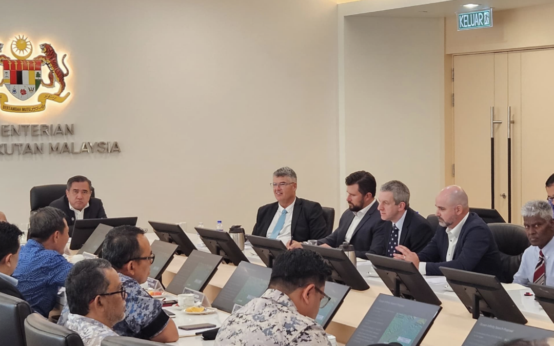
Ocean Infinity presented a new MH370 underwater search proposal to Anthony Loke, the Malaysian Minister of Transport in Kuala Lumpur on 2nd May 2024. Anthony Loke said that based on discussions held on Thursday, the company had submitted a proposal paper along with evidence and information for examination by the relevant parties under his ministry.
Josh Broussard, the Chief Technology Officer, of Ocean Infinity led the team making the presentation, together with their Commercial Manager.
Pete Foley, the former ATSB search director, also attended the meeting in Malaysia. Pete has been campaigning for a new search for several years and is advising Ocean Infinity on the new search.
Prof. Simon Maskell, from Liverpool University, is a scientific advisor to Ocean Infinity and was also in attendance at the meeting. Simon leads a team investigating the possibility of using WSPR to detect and track aircraft. Simon plans to add the WSPR data to the particle filter developed by the Australian Defence Science and Technology Group (DSTG) described in their book titled “Bayesian Methods in the Search for MH370” in order to refine the new MH370 search area.
The new search for MH370 is expected to start in November 2024. Anthony Loke said the whole process of examining the new proposal, including cabinet approval would take about three months. Two representatives of the Association for Families of the Passengers and Crew on board MH370 also attended the meeting. The Association welcomed the new proposal and thanked everyone involved.
Thank you so much for your tireless work on this Richard.
Tireless. Well said.
I think that OI and Malaysia have reached “a brick wall” over some “issue(s)”. Presumably, there is an impasse which neither side will back down on. If that is the case, then no contract for a “new” search will be signed.
What those issue(s) are we don’t know, because no one is leaking (yet).
As for current operations.
It has long been argued by many (and apparently OI agrees) that it is highly desirable, indeed necessary, to be certain that nothing has been missed in the areas original searched by the ATSB and the first OI campaign in 2018.
I think that what we are seeing now, is a campaign to tidy up the “old” search areas, effectively, doing Megan’s (Ref: The Geosciences Australia Presentation video long ago) “postman’s dilemma”. It all depends on how much of that “postman’s dilemma” OI intend to do (or can do in the time available).
If OI has decided that they will only do a carefully selected but limited priority subset of the postman’s dilemma, that can be done before Armada 78 06 has to depart for Cape Town, then we probably have about two weeks before that becomes clear, if she does in fact depart for Cape Town then.
If she does not depart then, but continues searching, it should be obvious by then (if AIS stays live) that they are doing the postman’s dilemma, in which case, they could add another week or so before having to return to Freemantle (since by that time Cape Town would be “logistically” out of range).
In that case, it would probably take a least another “full swing” to complete all of the “postman’s dilemma”, perhaps more, (which would require yet a third visit to Freemantle), and perhaps a bit more searching before she eventually departs for Cape Town (assuming THAT does not change either).
So, in summary, if OI remains silent, and Loke keeps coming out with sporadic “we are finalizing details…..” statements, all we can do is sit back and watch this rather childish pantomime play itself out.
Ventus- The scuttlebutt(rumor) to me from 2018 was that OI had proposed re-searching the Pheonix/Fugro areas 32-35s, and everyone wanted to do that except ATSB felt strongly it was not necessary. So the decision in 2018 was to use the search time to go north to 25s. So to extent, OI always wanted to do something like this.
Politics got in the way (as per usual).
At the time, the ATSB were under political pressure in Senate Estimates Committee Hearings (and elsewhere) to defend their selection of search contractor(s), the search strategy itself, and the costs.
Even if there had been any (internal to the ATSB) doubts about the quality of some data, in some area(s), and a preference to “re do” some area(s) they could not publicly admit that because they would have been politically attacked.
So, if OI wanted to “re do” 32-35s, they did not need ATSB approval to do so, but it would have made life uncomfortable for the ATSB if they did.
Perhaps OI were trying to stay in ATSB’s “good books”.
@ventus45,
I am encouraged by the fact that this time Ocean Infinity will not accept any constraints of a political nature.
It appears that the Ocean Infinity survey and search strategy is to leave no stone unturned.
@All,
Ocean Infinity are currently doing bathymetric survey work in preparation for a further underwater search for MH370 and have not actually started the search for MH370.
@ventus45 points out in his comment above that the Director of The Australian Digital Atlas, Megan McCabe, has pointed out there are gaps in the Geoscience Australia bathymetric data gathered in 2014 as a precursor to the underwater search by the ATSB, Fugro, Go Phoenix in 2014 to 2017 and later by Ocean Infinity in 2018.
Ocean Infinity have confirmed, that they have not yet started the actual MH370 search.
For god’s sake. How frustrating.To have thought they had been searching the past 2 weeks and might even be finished analysing the first bits of data from the so-called AUVs it deployed and now learn that that’s not the case is disheartening. So we’re nearly mid-March and no searching has been done. That leaves the search window very small indeed if it already wasn’t.
@Richard, I know you don’t have a crystal ball in terms of the weather, but at what point do you think OI would have to suspend the ‘search’ for this season until the weather improves in few months. End of April maybe?
@Louis,
If Ocean Infinity detect a possible aircraft debris field during their survey work, then they would return to that location to confirm the observation. The next step in the procedure would be to map out the debris field and gather photographic and video evidence of the aircraft wreckage. It is possible from identification markings like 9M-MRO or the Malaysian Airlines logo and colour scheme to then be sure that MH370 has been found.
In this event, then all further survey work would stop and Armada 7806 would concentrate on this single location.
You make a very good point, that the weather window will start to close towards the end of April or beginning of May in the Southern MH370 search area. In 2018, Ocean Infinity continued searching until the start of June in the Northern MH370 search area.
Hi Richard
Sorry if this question had been asked previously, but were there any shipping/fishing vessels within the WSPR area at the time of the crash? If so, do you know if the crew on these vessels were contacted?
@Sam,
We checked for any ships in the MH370 crash location at the time back in March 2014 and could not find any.
@Richard and co-authors: Kudos for your years of research by fusing data from WSPR with other sources, as well as for your almost daily updates & reporting lately.
@ventus45 While searching for “Postman’s Dilemma”, I came across “delivery man’s dilemma” in a citation of Ms Megan McCabe from Geoscience Australia “The goal was to prioritise anomalies to build a ‘road network’ between them that we could efficiently investigate.” in [1].
Which reminded me of the “Traveling Salesman Problem” from Computer Science about computational complexity where “Given a list of cities and the distances between each pair of cities, what is the shortest possible route that visits each city exactly once and returns to the origin city?” [2].
Do you happen to have any references to Megan’s “Presentation video long ago” you mention above? Thank you.
[1] https://www.spatialsource.com.au/scanning-the-depths-the-data-behind-the-search-for-flight-mh370/
[2] https://en.wikipedia.org/wiki/Travelling_salesman_problem
@HB9CWP,
Welcome to the blog and many thanks for the kind words! TU 73
i believe the video you were looking for is https://www.youtube.com/watch?v=dOcac4S_osQ . It was on watching this video that I had the feeling all was not well with the ATSB.
Yes, that is it.
@John Finlay,
Many thanks for posting this video of Megan McCabe explaining the geospatial work at the ATSB in relation to the search for MH370.
1. The ATSB had an initial search area of 1 Million km2, but a budget for only 60,000 km2 (6% of the budget required for the initial search area).
2. The ATSB had no previous experience in geospatial work and no data sufficient for a wide scale underwater search.
3. Political pressure was put on the ATSB to move from their survey work, more directly to an underwater search.
4. The scientific approach used by ATSB was constrained by budget and political pressure.
Thank you Richard for putting these constraints into awareness as they do have an effect on the quality of the information. This is a similar video from a colleague of Megan’s https://www.youtube.com/watch?v=QaXOK-n6l7o .
This video with a misleading thumbnail is a good Sunday evening watch https://www.youtube.com/watch?v=WoJ8Ulxslik .
@John Finlay,
Fascinating inside stories from two completely different perspectives.
@All,
An update today on the MH370 search from Airline News with Geoffrey Thomas:
https://www.youtube.com/watch?v=6vrXTIIwIp0
In today’s report we discuss the survey work being done by Ocean Infinity in the MH370 search area, before starting the search work for MH370. This has been confirmed by Ocean Infinity in an email sent to us. As soon as the search actually starts Ocean Infinity will put out a statement.
We also give an update on the track of 5 other aircraft in the vicinity of the MH370 flight path on the 7th and again 24 hours later on the 8th March 2014. Captain Martyn Smith observed an unidentified aircraft over the Indian Ocean on the night of 8th March 2014 crossing the flight path of his aircraft Emirates flight EK407.
‘the survey work being done by Ocean Infinity in the MH370 search area, before starting the search work’
Hi Richard, can you explain the point of doing a bathymetric survey to prepare for a search? Surely the search itself is all you need? Or do you need a bathy survey in order to understand the seafloor topo of which to guide the AUVs? also, I assume bathy surveys aren’t high res enough to pick up plane sized debris? thanks.
@Theo,
Welcome to the blog!
ATSB and Geoscience Australia made an extensive bathymetric survey prior to the initial underwater search in 2014.
It is important to know the sea floor topography, where there are sea mounts, volcanos, canyons, cliffs, ridges, etc.
Negotiating terrain features on the seafloor, for example a seamount where there is a steep gradient, requires a deep tow vehicle to be raised to clear the obstacle and then lowered after the obstacle is passed. This will often lead to sonar data degradation due to increased motion of the deep tow vehicle or a gap in the data termed a “terrain avoidance holiday”.
Autonomous underwater vehicles, once programmed and launched, can be completely independent of the support vessel and are highly manoeuvrable. They can search the seafloor effectively in any pattern, not just long continuous lines, and can closely follow dynamic seafloor terrain which often leads to better overall sonar coverage. They can also achieve higher resolution sonar data given they can safely fly closer to the seafloor than a typical deep tow vehicle.
The major disadvantage of AUV’s was previously the limited battery life of typically 26 hours in 2014, which has now significantly improved to 96 hours.
.
Has it been established whether any of the passengers on EK407 saw a nearby aircraft out the window on the night of 7th / 8th March 2014, or any other night in the preceding month?
While it looks amazingly coincidental that the flights tracked on 7th and 8th March 2014 were in such close proximity to the MH370 / EK407 intersection, it may be that some or all of them were involved in non-search related activities.
The fact that the Malaysian authorities, in the final safety investigation report, were unable to rule out “unlawful interference by third parties” might in part, explain their reticence to be saddled with 100% ‘trial by media’ liability for the disaster, and all that that would imply for their international reputation, not to mention their sovereign wealth fund.
While the search for MH370, at over $200 million, is often referred to as the most expensive in aviation history it is important to keep some sense of perspective.
One of the passengers on the plane was Ju Kun, a stunt choreographer who was working on the Netflix production of “Marco Polo”.
That series was cancelled after two series because it made a loss of $200 million.
“the decision to cancel was jointly taken by Netflix and The Weinstein Company” according to The Hollywood Reporter.
https://www.hollywoodreporter.com/tv/tv-news/marco-polo-canceled-at-netflix-two-seasons-955561/
@TommyL,
I agree that a search for MH370 is very expensive, but as you say, it is important to keep a sense of perspective. The list price for a new Boeing 777 is $330 Million. You cite a good example, that Netflix can make a loss of $200 Million an a series.
I have had no feedback from any other pilots on EK407 on 7th or 8th March 2014 or from Emirates. I have not asked for a list of passengers, as I am sure Emirates would not give out such information.
@All,
Following the AF447 crash in the Atlantic Ocean in 2009, Inmarsat as operator of a satellite network collaborated with Lockheed Martin as manufacturers of the satellite, to use the satellite data to help track aircraft.
In 2011 Inmarsat upgraded their ground stations to archive the Burst Timing Offset (BTO) and Burst Frequency Offset (BFO) data. The BTO data tells you how far the aircraft is from the satellite and the BFO data tells you the relative velocity between the satellite and the aircraft.
Inmarsat were well prepared should another event like AF447 happen and when MH370 disappeared, they immediately shared their data with officials like the NTSB (US) and AAIB (UK) and industry partners like Boeing (US), Rolls Royce (UK), Lockheed Martin (US) and Thales (France).
Do you think there was something on board MH370 that should not have been on board and this is the reason the Malaysian government is so reluctant to find the aircraft
@Robert White,
Welcome to the blog!
The reluctance in Malaysia is with members of the Air Force and the former government. Most others in Malaysia are in favour of a new search or are simply indifferent.
The Malaysian civilian Air Accident Investigation Bureau is staffed almost entirely by military Royal Malaysian Air Force officers.
I would be speculating to state that I think they are hiding something, I simply do not know the reason for the reluctance.
For I think they need to so a deeper into their past and their connections to see who they really are or even who they are related to.
I really love your idea it is quite possible. Or just maybe they’ve already found the aircraft and they just decided not to tell us for they do not want to share to the public what they found on that plane
@All,
My co-author on our various papers on WSPR, Prof. Simon Maskell is a scientific advisor to Ocean Infinity and was present at the meeting in Malaysia in May 2024, where Ocean Infinity presented their proposal for a new search for MH370.
@All,
An update today on the MH370 search from Airline News with Geoffrey Thomas:
https://www.youtube.com/watch?v=SshXUeuDXF4
Today we give an update on the survey work currently being done by Armada 7806.
We have been asked who are the experts, what are the different theories, how do the experts collaborate, what are the qualifications required and answer several similar viewer’s questions.
@Richard,
Thank you, again, for a truly informative episode and for keeping us all updated regularly. Here’s hoping that Malaysia kick themselves into gear and sign the contract ASAP, so the search can actually begin!
Hi Richard. Great work on WSPR!
If the contract between Ocean Infinity and the Malaysian government remains unsigned, will there still be a survey or search of the WSPR area and if so when?
@Roger,
Welcome to the blog!
Ocean Infinity have always said that they will only search for MH370 with a signed agreement.
If that doesn’t happen, for whatever reason, then others will step in. It will probably be too late to commence a new search in this search season, so I think the search will be postponed to November 2025 and the start of the new search season.
My philanthropist friend is following events closely with Malaysia and Ocean Infinity. He has also done his own research into WSPR and we have given him and his team a video presentation of the WSPR technology.
Hi Richard,
I have some questions that I am not sure were ever asked. When MH370 made it’s turn to the south how come Indonesia never detected the plane on civilian or military radar? It seems based on the track suggested based on WSPR it was not far off the western shore of Indonesia for a short while. I am also curious if Thailand civilian or military radar was able to detect the plane at any point. It seems we were only given Malaysian radar. If MH370 is not found in the search area, based on the theories proposed by WSPR or otherwise, how can we even know where else to search? Also, I am curious if it is possible to get my hands on the software and data used for WSPR as I would love to understand how it works.
@Jon,
The Indonesian authorities released a report stating that their radar on an island just off the coast at Sabang was shut down for maintenance on the night of 7th March 2014.
The Indian Air Force has a radar on the Andaman Islands, but this is shut down at night in peace time.
Thailand and Malaysia have never released their military radar data, but we do have all the Malaysian civilian radar data and ADS-B data.
@Jon,
Prof. Simon Maskell and his team at Liverpool University have a WSPR tracking system that can start scanning anywhere at anytime. They use a high power computer network and operate with big data, which can track 75,000 aircraft which are in the air during a 24 hour period. The system knows all the historical WSPR data and all the historical ADS-B data.
My system for tracking aircraft starts from a last known point and moves forward every two minutes from that particular position and time. My lap top takes two minutes to process two minutes of WSPR data and much longer to process two minutes of ADS-B data for 20,000 aircraft, that are in the air at any one time.
Please send me an email when you have watched the live software process walk through video and set up your Matlab environment. You might also be interested in these two videos from Daily Airline News with Geoffrey Thomas, where we also did a live demonstration of WSPR and explained how radio waves interact with aircraft.
https://www.youtube.com/watch?v=NuDF_hP2Rlc&t=295s
https://www.youtube.com/watch?v=nBZvUN2gBCc&t=4s
In addition to what Richard has said, Indonesia reportedly was operating several secondary radars to monitor commercial traffic, which of course would not capture MH370 if the Xponder was off. Presumably the joint investigation team might have been advised about confidential Thailand and Singapore radar findings if they saw anything, and almost as important, where they did not see anything. We are public and there is much information/data that we are not allowed to know. However, I do feel there was an effort to be open as possible to allow flight path estimates.
One only has to look at the simulator data to see a data source, where we need the data, but it is still withheld. When leaked it was incomplete or redacted for unknown reasons (sensitive apparently). The point I am trying to make, we the public have the data only to the extent Malaysia/others are comfortable releasing it, and there could be gaps. Hopefully we have what we need.
@TBill,
You and I have both had some success with the release of data under confidentiality agreements with the ATSB and AMSA. Brian Anderson had success under a freedom of information with the RNZAF. Prof. Simon Maskell has the DSTG Bayesian Methods model. The FBI have also been requested to release the data recovered from Captain Zaharie Shah’s home flight simulator and Victor Iannello and Yves Guillaume did a great analysis on the data which is in the public domain.
Would 7806/O.I be headed Northwards soon, towards the main hotspots and broken ridge?
@Low_Taper_Fade,
Welcome back to the blog, this time not with your actual name, but with a new pseudonym! I have an appointment with my barber on Monday.
I am thinking of using the pseudonym “Short Fuse”. 🤣
I do not expect Ocean Infinity to start searching for MH370 until an agreement is signed with Malaysia. Once they have completed their survey work, then if an agreement is still outstanding, they will move on to other projects.
Hi Richard,
I find it fascinating to see people take established technologies and use them for entirely new applications. Sometimes there can be significant issues that need to be addressed when doing this however.
I notice that Professor Joe Taylor is quite skeptical about using historical WSPR data to track aircraft. Are you able to shed any light on why he has this view? I would also be interested to know whether you have discussed this issue with him yourself, and if his views have caused you to amend the way you use this technology to track MH370.
Apologies if you have already covered this.
@Tony,
Welcome to the blog and for the thoughtful words!
Prof. Joe Taylor is an eminent physicist, Nobel prize winner and the man who invented the WSPR protocol. He is also a keen amateur radio enthusiast. Prof. Joe Taylor is on the record as stating you cannot use WSPR to detect and track aircraft.
Christian Entsfellner, the Chairman of the German Amateur Radio Society knows Prof. Joe Taylor and has met him personally. Christian tried to set up a conference call with Prof. Joe Taylor and Prof. Simon Maskell, Dr. Hannes Coetzee and myself, where he would moderate a discussion on our work on WSPR. Joe Taylor, who is now 83 years old and has long since retired, declined the invitation.
I have been invited to speak on WSPR at the Annual Conference of the German Amateur Radio Society on the occasion of their 75th Anniversary this year. This debate will continue.
All truth passes through three stages. First, it is ridiculed. Second, it is violently
opposed. Third, it is accepted as being self-evident. – Arthur Schopenhauer
Hi Richard,
What do you make of Vincent Lyne’s theories behind the Lyne Hotspot?
@tph,
Welcome to the blog!
I have a hard time following the unconscious processes, baseless thoughts and mystical dreams of Vincent Lyne, which the author admits he cannot even explain himself.
I am familiar with the papers Vincent Lyne has written, some together with his wife Melissa Lyne. Vincent Lyne is a retired research scientist in the areas of livelihoods, climate change, marine spatial planning and ecosystem characterisation. Melissa Lyne is a freelance communications specialist in science, medical and environmental media. Neither of them are aerospace engineers, satellite communications experts, hydroacoustic experts, nor oceanographers.
Vincent Lyne’s hypothesis is: “The final hydroacoustic message from MH370 provides a vital 8th arc from the Perth Canyon that signals a narrow landing range along the Broken Ridge near where the 33°S latitude is intersected by the longitude of Penang at an ultra-deep hole approximately 6000 m deep.”
There are only 7 Arcs, defined by Inmarsat satellite data. There is no mysterious 8th Arc.
In his various papers, Vincent Lyne states: ”I am unable to explain how the thoughts of Penang, leading to a reanalysis of the sound, entered my head; I can hear it now but can’t explain how.” and ”Those thoughts incubated in my mind, and on the day of Capitol Hill riots (6th January 2021) I woke with a mental image of a longitude line drawn from Penang to the region I marked out in March 2019—which led to this report.”
In my view, Vincent Lyne does not give any scientific explanation as to why the longitude of Penang should determine the crash location of MH370. Furthermore, Vincent Lyne’s crash location disagrees with a number of major scientific analyses: 1. Hydroacoustic analysis of Dr. Alec Duncan of Curtin University, Australia. 2. Inmarsat satellite data analysis by Chris Ashton et al. published in The Journal of Navigation. 3. MH370 Burst Frequency Offset Analysis and Implications on Descent Rate at End-of-Flight by Dr. Ian Holland of the Defence Science and Technology Group (DSTG) in Australia.
Vincent Lyne’s nonsense appears to be a marketing ploy in promoting another set of nonsense, namely Larry Vance’s book on MH370. Vincent Lyne’s obsession with the PL (Penang Longitude) and the PL Hole also results from profoundly disturbing imagery, that he provides of a heart with wings, tears and multiple mentions of a reborn foetus being carried away from the MH370 crash location.
Here are some quotes from a more recent paper by Vincent Lyne:
“Let your imagination free, and you will see wings on the north western part of the Hasetiho, mirroring the relative same location of the flaperon on the island, and a foetus in the southern half formed from the sediment-laden river of tears. A reborn foetus being carried away in a heart with wings. Yes, it’s not a scientific interpretation (how could it possibly be!), but have a heart and let those who have lost ones take some comfort from this interpretation.”
“Permit yourself some wild imagination and you will see the wings north-west of the heart, and the embryo cradled in the south. Top insert shows the bathymetry of the island, which suggests that the “embryo” may be from sediment-laden outflow—the river of tears that painted the foetus. The wings and flaperon are both in the north-west portion of their homes. Figure and interpretations dedicated to the innocent lost ones of MH370 and to my daughter Baba (the “reborn” artist who wanted to fly “free”.”
“Days before the flaperon is discovered, rain washes over the island, carrying its volcanic soils to the southern recirculation, to paint a picture resembling a foetus. The opposite circulation in the north creates a set of wings, carrying away the foetus cradled in the south.”
Vincent Lyne proves his theories by quoting papers authored by V. or M. Lyne, as the key authorities on MH370, in total 15 times. It is abnormal for a scientific work to rely on other work by the same author(s) to prove a point.
There are the other papers by Vincent Lyne, each paper with more abstruse theories than the one before.
Vincent Lyne summarises that this has been a “lonely journey” of analysis to understand the “cryptic pathways” of MH370 and he has “accomplished the job assigned to him” and he has “carried out the task, as far as he needs to go.”
Vincent Lyne, I would say, starts with a hypothesis that MH370 crashed far from Arc7 along Broken Ridge in a selected deep spot. Vincent correctly surmises the popular MH370 assumptions of straight, maneuver-less flight, passive pilot, with fuel exhaustion at Arc7 do not allow for such a deliberate hiding act.
It turns out, Lyne’s scenario is similar to what I think happened, based on many flight sim studies. However, we only have BTO/BFO flight data up to Arc7, If MH370 kept flying after Arc7, with fuel, the question would be what direction did it fly?
After Arc7, it’s an educated guess based on debris drift, acoustic evidence (if any), human behavior assumptions, cloud contrails, etc, Vincent spends a lot of time talking about this “secondary” evidence and why he thinks it points to Broken Ridge as the target after Arc7.
Briefly, more fuel is possible after Arc7 because a flight path that curves over 31-32s to Arc7 is a shorter distance, and also the descent from high altitude can occur before Arc6 (if we are allowed accept active pilot scenario).
@All,
An update today on the MH370 search from Airline News with Geoffrey Thomas:
https://www.youtube.com/watch?v=rgF04eJPT0M
Armada 7806 is still working in the second survey area. Ocean Infinity are currently doing bathymetric survey work in preparation for a further underwater search for MH370. The 2nd survey area is much more compact than the 1st and the AUV missions appear much shorter.
We discuss the work of Pete Foley, the former ATSB MH370 Project Director and current advisor to Ocean Infinity on the MH370 search and Andy Sherrell the Director of Maritime Operations at Ocean Infinity and our collaboration over the years.
We also discuss Prof. Joe Taylor and the attempted collaboration under the mediation of Christian Entsfellner, the Chairman of the German Amateur Radio Society. Prof. Joe Taylor is an eminent physicist, Nobel prize winner and the man who invented the WSPR protocol. He has now retired, but he is also a keen amateur radio enthusiast. Prof. Joe Taylor is on the record as stating you cannot use WSPR to detect aircraft.
I have been invited to speak on WSPR at the Annual Conference of the German Amateur Radio Society on the occasion of their 75th Anniversary this year. This debate will continue.
All truth passes through three stages. First, it is ridiculed. Second, it is violently opposed. Third, it is accepted as being self-evident. – Arthur Schopenhauer
@ Richard,
A lot of viewers are relieved to hear on the latest Airline News with Geoffrey Thomas –
Despite the bathymetric survey, OI can still identify/discover MH370 wreckages..
@Jafni,
It would be much better, if Malaysia actually signed the contract with Ocean Infinity, then they could start the search for MH370 as soon as they complete their survey work.
@All,
Armada 7806 is still working in the second survey area. As confirmed by Ocean Infinity they are currently doing bathymetric survey work in preparation for a further underwater search for MH370. Here is a link showing the current position of Armada 7806 as of 15MAR2025 11:31 UTC:
https://www.dropbox.com/scl/fi/zynd5jzzai5non4yolf45/Armada-7806-Vessel-Finder-15MAR2025-1131-UTC.png?rlkey=gx9wchsypqed9b41fh586snqq&dl=0
Here is a link showing the position of Armada 7806 as of 15MAR2025 05:21 UTC, when the ship was at a standstill for over an hour for AUV operations:
https://www.dropbox.com/scl/fi/ax3h6diy1d9mcwt6ok52c/Armada-7806-Vessel-Finder-15MAR2025-0521-UTC-Zoom.png?rlkey=e7lx6b1s6oe5wr9z4yi6uq1gq&dl=0
Here is a link showing the position of Armada 7806 as of 15MAR2025 05:21 UTC, in relation to the track of Go Phoenix on 21JAN2015, Fugro Supporter on 27JAN2015, Fugro Discovery on 24FEB2015 and Seabed Constructor on 28JAN2018. It is quite apparent that Ocean Infinity are filling in gaps in previous searches:
https://www.dropbox.com/scl/fi/d01roktjgss3054vznime/Armada-7806-Vessel-Finder-15MAR2025-0521-UTC-vs-Previous-Searches.png?rlkey=1ppesy2scctzhply5080i8oc9&dl=0
Richard – Is it possible in your opinion to further enhance the WSPR predictions that you have come with in this case ? Sometimes others can look and do look at data differently and come up with different answers.
@Barry,
That is exactly why I am sharing my work, source code and data with as many as people as possible. This has already been proven to be very helpful with the team at Liverpool University. Prof. Simon Maskell and his team of researchers, data scientists, PhD students and post doctoral researchers. Simon is part of a wider network of academics in a large number of universities and research institutes, who are also now involved.
Hi,
I’m new in this thread but not new at following the search for the wreckage. I am wondering why the area from Jean Luc Marchand and Captain Blelly has not been searched for yet. Like, in the phase1 of 2025, OI searched in a zone that was already looked after the previous years. But so far nobody went to the Blelly area. Why ?
@Luca,
Welcome to the blog!
The short answer to your question is that Ocean Infinity has not yet started the search. They are currently doing survey work filling in gaps in the bathymetric data previously collected, in preparation for the search work.
For their AUV mission planning, it is important to have a complete picture of the sea floor terrain.
Take a look at the video, that another commenter John Finlay shared at this link:
https://www.mh370search.com/2024/05/05/new-search/comment-page-8/#comment-3879
I expect, as soon as Malaysia sign a search agreement with Ocean Infinity and as soon as their survey work is complete, that they will revisit the IG hot spot, cover the Captain Patrick Blelly / Jean-Luc Marchand hot spot, the WSPR hot spot and possibly other areas in a thorough, rigorous and methodical search strategy.
Thank you for your answer! However it seems that sometimes the OI ship stops. Is it to launch AUVs? I understand the point of having important pictures of the sea floor however shouldn’t they at the same time do the search with the AUVs? Obviously I’m not a search expert, but I’m wondering. I can’t imagine they only do sea floor images and could miss precious days of search by not « searching » at the same time? Does that make any sense?
Secondly, does that mean that in a few days they will go to the expected destination in Cape Town (which is far away!) and then come back in the search zone ? That seams a lot of travel. Cape Town is like 7 days travel at least, no?
@Luca,
Armada 7806 has stopped many times in the past 5 days on this swing. Sometimes it is a short stop, where the ship is listening out for an AUV. When the stop is for a longer period typically between 30 minutes and 90 minutes, then this usually means an AUV launch or recovery operation.
ChatGPT summarises the difference between survey and search work as follows:
Ocean Infinity uses its Hugin 6000 AUV in missions that, while similar in technology and equipment, differ primarily in purpose and operational approach:
Objective and Mission Planning:
In underwater survey work, the goal is to systematically capture detailed data about an area. This means creating high‐resolution maps, 3D models, and collecting bathymetric and environmental data for applications such as geological assessments, infrastructure planning, or ecological studies. In contrast, underwater search work is more targeted—it focuses on finding specific objects (like wreckage or debris) based on known or estimated positions. Search missions use mission planning optimized to cover areas of interest (often guided by last-known positions or drift models) rather than providing exhaustive mapping.
Data Collection and Processing:
Although both operations may employ the same suite of high-resolution sensors (multibeam sonar, imaging systems, etc.), survey work is designed to yield continuous, overlapping data that builds a detailed picture of the seafloor. Search work, on the other hand, prioritizes detecting anomalies or targets within the data; post-processing is geared toward verifying the presence and identity of a specific object rather than producing an overall map.
Operational Approach:
Survey missions are generally methodical and systematic—often using grid patterns to ensure full coverage—while search missions might adjust their patterns dynamically to focus on areas that are statistically more likely to contain the target. This difference in approach means that survey work is often used to establish baseline environmental or geological information, whereas search work is executed under the pressure of finding a particular item or wreck quickly and efficiently.
Summary
In summary, while both survey and search missions utilize the advanced capabilities of the Hugin 6000 AUV, survey work is about broad, detailed mapping of an area, and search work is about pinpointing a specific target within that area. This distinction guides everything from how the mission is planned to the way data is collected and analyzed.
Obviously, if Ocean Infinity identify a debris field or larger items of wreckage, during the survey work, they will stop the survey work and move directly to investigating the point of interest in order to determine whether this is aircraft debris and whether it can be identified as being from MH370.
I expect Armada 7806 will use Fremantle, if they stay in the MH370 search area for longer. Armada 7806 is still showing Cape Town as the next destination with an ETA on 24th March 2025 in 8 days time. That is no longer possible as it would take around 15 days at 10 knots to reach Cape Town from the current position. Armada 7806 has a maximum endurance of 35 days and has already been at sea for 10 days.
WoW, that’s super interesting thank you very much. From all the definitions you mentionned in your last comment, it seems to me that we cannot say for sure if OI is doing survey work or actual search. I mean they could easily do a survey for 48h and then move to a search within the same area if the survey potentially indicates wreckage parts?!
@Luca,
You state: “we cannot say for sure if OI is doing survey work or actual search.”
Wrong!
As I previously responded to you: “Ocean Infinity has not yet started the search.”
As mentioned yesterday: “As confirmed by Ocean Infinity they are currently doing bathymetric survey work in preparation for a further underwater search for MH370.”
Please look at this comment on 12th March 2025:
https://www.mh370search.com/2024/05/05/new-search/comment-page-8/#comment-3833
“We discuss the survey work being done by Ocean Infinity in the MH370 search area, before starting the search work for MH370. This has been confirmed by Ocean Infinity in an email sent to us. As soon as the search actually starts Ocean Infinity will put out a statement.”
Notwithstanding that Ocean Infinity have said that they’re surveying rather than searching, the movements of Armada 78 06 since 11 March seem to be very tightly focused and look more like a search than a survey to me.
There is considerable overlap between the two activities, so I suspect OI are taking advantage of this and calling it a survey in order to stay true to their earlier statement that they wouldn’t search without a contract.
@Duncan,
1. OI have stated they are not searching at the moment.
2. OI have consistently stated they will not search without an agreement with Malaysia.
3. OI have stated, they will make an announcement, when the search starts.
4. Megan McCabe in her presentation video explains the number and extent of the data gaps in the original bathymetric survey.
5. I have shown that OI are currently surveying areas, where there were data gaps identified or no bathymetric data from any previous search by Go Phoenix, Fugro Equator, Fugro Discovery, Fugro Supporter or Seabed Constructor.
6. The IG hot spot is based on their analysis, that there is difficult sea floor terrain, absence of complete bathymetric data and a real possibility that MH370 was missed.
@Duncan
If we assume that:
(1) no contract has yet been signed (no one is talking) AND
(2) OI has had time enough to fully review the data that A7806 collected at the IG hot spot two weeks ago, AND
(3) OI did not find anything there……….
AND, bearing in mind all the points Richard listed (nothing new – just restated for the record)…..
Could it be that:
(a) 7806 is NOT doing bathy work…….
(b) 7806 is NOT doing a MH370 search…….
but rather:
OI may be just letting Malaysia demonstrate their true colours to the world, by:
(c) letting everyone THINK that A7806 is doing 370 related work, but may in fact be…..
(d) searching for something else entirely – like a ww2 wreck – for example ?
Thank you very much Richard for the detailed answers. I feel more informed now on my quest to follow the future discovery of the wreckage.
Do you have any estimates as to when OI could start the search ? Meaning is the survey going to last several months or rather days ?
@Luca,
Listen to the experts like Megan McCabe, there are a large number of data gaps and the ATSB were working under political pressure and budget constraints.
The outstanding survey work could take weeks.
@All,
An update today on the MH370 search from Airline News with Geoffrey Thomas:
https://www.youtube.com/watch?v=pX2Xd9xx6Vc
In today’s report we compare the position of Armada 7806 as of 15MAR2025 05:21 UTC, in relation to the track of Go Phoenix on 21JAN2015, Fugro Supporter on 27JAN2015, Fugro Discovery on 24FEB2015 and Seabed Constructor on 28JAN2018. It is quite apparent that Ocean Infinity are filling in gaps in previous searches.
https://www.dropbox.com/scl/fi/ax3h6diy1d9mcwt6ok52c/Armada-7806-Vessel-Finder-15MAR2025-0521-UTC-Zoom.png?rlkey=e7lx6b1s6oe5wr9z4yi6uq1gq&dl=0
https://www.dropbox.com/scl/fi/d01roktjgss3054vznime/Armada-7806-Vessel-Finder-15MAR2025-0521-UTC-vs-Previous-Searches.png?rlkey=1ppesy2scctzhply5080i8oc9&dl=0
@All,
An update today on the MH370 search from Airline News with Geoffrey Thomas:
https://www.youtube.com/watch?v=dIGpWhEOWbg
In today’s report we look at aircraft missing without trace.
Since 1948 there have been a total of 89 aircraft, that are missing and where the wreckage has never been found.
There have been 8 aircraft since MH370, that have gone missing.
We take a quick look at a few of the other cases.
@Richard,
Would A7806 have enough fuel to go for WSPR hotspot after surveying nearby Blelly area?
Or would it return to Australia first?
I sincerely believe they are already conducting a search operation, since Armada 7806 is clearly conducting constant sweeps in a very small area. Although OI claims they are “barimetric surveys,” I believe they are searching for the plane. If I understand correctly, that area already has its “barimetric survey,” so I positively estimate they are searching for MH 370 in those search areas. I believe Armada 7806 doesn’t have enough fuel to go north to the WSPR zone, so as you and Richard say, it should go to Australia for supplies and refueling.
https://www.mh370-caption.net/index.php/armada-tracking/
I “clearly” see a search pattern on this map. Look how close it is to the places already “covered.”
Omar
@Omar López,
Your assumption “I sincerely believe they are already conducting a search operation” is wrong!
The CEO of Ocean Infinity, Oliver Plunkett, has stated otherwise in an email to me.
There are both areas with data gaps, i.e. missing data and areas not previously covered in bathymetric surveys!
@Jafni,
Armada 7806 is doing a thorough job of surveying the areas it wishes to search later. They spent 5 days in the 1st survey area around the IG hot spot. They have spent 6 days so far in the 2nd survey area.
Armada 7806 has enough fuel for 35 days plus reserve. They have been at sea for 11 days and need 5 days to return to Fremantle, Australia. That leaves a maximum of 19 more days in the MH370 search area.
Armada 7806 at 10 knots (maximum economical speed) can cover 4,560 nmi in 19 days.
The Blelly/Marchand hot spot is 36 nmi from the current position of Armada 7806.
The IG hot spot is 84 nmi further North East.
The UWA hot spot #1 is 163 nmi further North East.
The UWA hot spot #2 is 209 nmi further North East.
The WSPR hot spot is 78 nmi further North East.
A total of 570 nmi is not constrained by fuel, but is constrained by the time available on site in each swing.
Hi Richard,
Like many people, I appreciate your dedication to keeping the interested public apprised with the latest information regarding the search for MH370.
It seems that there is now a real possibility that the Malaysian government will simply never sign an agreement with OI. What do you believe that OI will do if that is the case? I know that you have previously said that OI will not begin an official search until the agreement is signed, but do you believe that they will actually abandon the search if there is no signature?
I seem to remember you mentioning that there would be other parties willing to fund or participate in a search if the OI search fails for whatever reason. Do you believe that other searchers would have access to the same kind of technology that OI has or is it a possibility that somebody else could fund the existing OI search?
@Tony,
If Malaysia announce that they will not be signing an agreement with Ocean Infinity or try to run the clock down until the weather in the MH370 search area deteriorates to the point, that searching is no longer safe, then my guess is that Ocean Infinity will come back next search season, which starts in November 2025, to continue the search until they find MH370.
Oliver Plunkett has stated publicly, that it is one of his life ambitions to find MH370.
Deep Sea Vision has a custom built Hugin 6000 AUV, which they used to search for Amelia Earhart’s plane.
aqua satellite have developed a new type of AUV, which has already been demonstrated to the US Navy.
If Oliver Plunket is serious about actually finding MH370, I would personally advise that MH370 is probably a case of deliberate hiding of the aircraft and the “establishment” is not too interested in finding that case, nor too interested in telling OI where to realistically look. The best OI can probably do is rule out the popular assumptions where folks are willing to search. That much would provide an element of closure for NoK and Malaysia.
@TBill,
I think Oliver Plunkett is serious about doing a $70M deal.
@All,
Armada 8601 will be arriving soon in Singapore following sea trials in the South China Sea:
https://www.dropbox.com/scl/fi/6on9rub75wk56xwswjj2v/Armada-8601-Vessel-Finder-17MAR2025-1551-UTC.png?rlkey=vslk0pqqarhnimv5s3ed7n38y&dl=0
Some of you might not like what I have to say here – especially lower down in this comment.
I think everyone looking at this website wishes MH370 to be found asap one way or the other.
Some of you have questioned whether OI are searching now and others have said that this is not the case, instead you have said that OI are carrying out important survey work. I submit that OI might already know where the wreck is resting or if not have a good idea but will not say so, until a signed agreement is in place for the obvious reason “of wishing to get paid” – for their work.
If this season passes, then maybe next year another benefactor would come into the frame to pick up the tab ? I am now thinking that the aircraft will only materialise – when the $70m contract is signed.
Until then it is my belief OI will carry on doing surveys or look for options for next year.
We are therefore in a window of opportunity for the malaysians to say “yes” we will back you this time out or for them to say “no” we will not play ball – thankyou very much.
This is my view. Its a game of cat and mouse of sorts or at least this is how it looks – this is not nice especially for those who have put a lot of work into this,but without someone picking up the tab to pay for this work, what else can be done – how else can OI play it ?
All of us can see that the Malaysians either have something to hide or if not have something that is truly holding them back.
As of today, considering the position we have – until the malaysians get off the fence one way or another (which is not happening as all of us can see) – I think we should all go and watch the television / go & have a meal or go and watch the tennis.
This is because this is precisely what the Malaysians are doing – nothing at all – we should all face up to that possibility – barry
@barry,
I can sympathise with your harsh words. In the absence of any official statement from Malaysia or Ocean Infinity, we are left with no alternative, but to face the cold hard truth you outlined.
I feel for the next of kin, who are looking to the Malaysian authorities for help and closure. They have greeted the Ocean Infinity proposal and the agreement in principle by Malaysia.
I think of the flying public, who want confidence in the aviation industry and the world’s airlines.
Now, the time has come for Malaysia to step up to the plate.
The Malaysioans are probably not , as you say, ‘doing nothing’.
The Malaysians, like every other nation, are probably watching developments closely, both domestically and internationally.
The fact that no agreement between the Malaysian government and OI has been announced suggests that, on balance, the perceived ‘risks’ of successful location and recovery of the wreckage, in the current fractious geopolitical climate, outweigh the benefits.
If a successful search and recovery of MH370 becomes weaponised, and, as a result, increases domestic, regional and global hostilitities, it is likely to be of limited genuine long-term help to the relatives and friends of the predominantly Chinese and Malaysian people who died, or to the global aviation community.
Hello, Richard! Thanks for your updates!
My question is: if there were drifting fragments of medium or large size on the ocean surface and they sank to the bottom after some time, is it possible to find such a fragment on the bottom during the search, even if the main part of the fuselage of the aircraft is in another place? By analogy with AF447, could modern technology have discovered its tail unit or on-board kitchen at the bottom of the Atlantic if they had sunk after days of drifting?
And the second question is: what is the depth of the silt layer in this area of the Indian Ocean? Can a destroyed plane completely “go” into the mud, or does it just cover the plane from above, but it will be perfectly visible? Or does it strongly depend on its location?
Thank you.
Hi Edward, The recovered pieces of MH 370 floating debris indicate that there is no main part of the fuselage left. Small shattered heavy pieces would sink straight down, and remain peacefully the seafloor. It is unlikely they would be covered by silt and mud, but even if they are can still be detected. With Ocean Infinity’s great technology they can even be found down a trench.
In 1962 a research vessel, Argo, part of the Lusiad Expedition, took a core sample of the seabed near 33S 96E at a depth of 4328m that was 4.25m long and consisted of foraminiferal mud. I believe the essentially intact fuselage of 9M-MRO has sunk into this mud which could well be deeper than the 4.25m length of sample collected. The 777 has a fuselage “diameter” around 6m. Interestingly at this point on the ocean surface, a day previous, a rendezvous had taken place with another Lusiad research vessel, Horizon, and the destroyer HMS Cavalier, for the transfer of crewmen, one of whom needed a hospital some 1140 miles away in Fremantle..
@John Finlay
The fuselage of 9M-MRO, the aircraft of MH 370, is not “essentially intact.”
I have found and held in my hands more than a dozen shattered pieces of debris from the 9M-MRO fuselage and main cabin, and I was not 4000 meters underwater nor buried in mud.
I have also found and held in my hands about ten pieces of shattered debris from different parts all over 9M-MRO.
I am unaware of how many pieces of 9M-MRO you have found, but suspect the number is about zero.
It astonishes me that so many armchair experts continue to stick their heads in the sand or mud, deny the debris evidence that I and other private citizens have found, and continue to insist that the fuselage is “mostly intact,” or that the plane is in Kazakhstan or shot down in the South China Sea.
You are of course free to continue to believe whatever you wish. I on the other hand believe in science and evidence and respect actual results.
Since graduating with a chemical engineering degree in 1988 I have seen the results of more than one hundred high speed crashes (impacts) between solids and liquids. A look at a photo of the recovered flaperon is enough to confirm it was not involved in a high speed impact with water. This is the science and it is very elementary physics about an impact between a compressible solid/gas body and an INCOMPRESSIBLE liquid. The result is the same every time. The solid with a modulus of elasticity will shatter. Liquids do not have a modulus of elasticity. You can’t compress a liquid and the faster you try to do so (high impact) the faster it fights back.
The definitive analysis of ALL of the evidence, at the time, from the disappearance of MH370 was presented in a book written by Larry Vance – MH370 : Mystery Solved. The book presents the findings of HVS Aviation – a team of 3 air crash investigators with a wealth of experience and expertise. A controlled landing (ditching) on the surface of the ocean with both wings level is the only way to explain ALL of the evidence. The ATSB in their analysis have ignored some evidence to get to the impossible conclusion (ye cannae change the laws of physics) of a high speed impact. This astonishes me.
I have a lot of respect for the determined work that you do in the search for MH370 specifically for the debris you have tracked down. Debris that was created on the surface of the ocean and all of which can be explained by a ditching of 9M-MRO.
Fascinating John. Where did you get that information from ? (link ?) I think HMS Cavalier had been based on the island of Gan.
This is the link to the report. https://escholarship.org/uc/item/2q24q7ss . The time period that is relevant is November 1962. The main body of the report is an easy narrative. The core samples of the seabed are in Appendix F and the one I referenced is for 22 November.
I bought a book on HMS Cavalier and had correspondence with the author. The ship was the fastest destroyer in the fleet attested to by a race of which the video is on YouTube. She made the 1140 mile trip to Fremantle in under 48 hours albeit with a re-fueling on the way!. I have obtained a photograph taken in the southern Indian Ocean by a crewman on board Cavalier of Horizon ready to transfer the seamen. HMS Cavalier, as she is still called, is permanently in dry dock in Chatham, UK.
Cavalier and Horizon are both Starships of the fleet, and Argo is a shuttle on board USS Enterprise.
For the level of detail, perhaps take a look at the images of the shipwrecks found as part of the 2015 search. They don’t appear to have disappeared into the mud in the areas they were found.
@All,
An update today on the MH370 search from Airline News with Geoffrey Thomas:
https://www.youtube.com/watch?v=J2xLynlps14
In today’s report we discuss the observation by Capt. Martyn Smith of an unidentified aircraft in the middle of the Indian Ocean on 8th March 2014, the day after the disappearance of MH370.
Dear Richard,
Thank you so much for your outstanding work and for keeping the public updated!
I have a question on the flights XX, YY and ZZ you were able to track in the MH370 search area on March 8, 2014.
If I understand it correctly, these flights were in proximity to EK407 at 18:45 UTC on that date, which should be in the middle of the night at the search area.
Does it make any sense to search for a missing airplane on the ocean in total darkness the middle of the night?
Richard I am told there are no ROV’s on the ship, and I got in some trouble for repeating that on X, even though I qualified as needing verification.
@All,
An update today on the MH370 search from Airline News with Geoffrey Thomas:
https://www.youtube.com/watch?v=yDdODcUn3RA
We discuss some of the legal aspects of the MH370 incident raised by various viewers, regarding searching in international waters, responsibilities for the search, ownership of the wreckage, salvaging the wreckage, compensation for the search and salvage efforts, as well as participants and their roles in the investigation.
Hallelujah!
https://www.straitstimes.com/asia/malaysia-agrees-terms-for-restarting-mh370-wreckage-search
@All,
Malaysia has formally announced that they are willing to sign the agreement with Ocean Infinity for a new search for MH370:
https://www.dropbox.com/scl/fi/m6ieucbwwlw9xf05y6cul/Malaysia-Approval-19MAR2025.png?rlkey=zejz4e5n6h2bpumlhzwxg8vow&dl=0
@Richard
I wish it was formerly, as in long ago, but I think you mean formally!
And I see the press release yet again mentions 15,000 km². I really hope that Ocean Infinity haven’t agreed to any restrictions on where they can search.
@Duncan,
Many thanks for the correction, I was so excited, I was tripping over my English to make the announcement!
This is great news, however I’m not holding my breath until it’s completely signed and confirmed. Hopefully we will get a public statement from Ocean Infinity soon.
@All,
Fantastic news on the MH370 search from Airline News with Geoffrey Thomas:
https://www.youtube.com/watch?v=as2s893IYfM
Armada 7806 will now be able to start the search for real.
Armada 8601 is also on standby, in Singapore, if required to help the search effort.
I am not quite sure to understand.
On the 13th of December, 2024 the government already “agreed in principle” as you can see on this video: https://www.youtube.com/watch?v=oOP2Mhh6g44&t=5s
There was some conditions of the contract to be discussed, but they already agreed on a “no find no fee basis”.
So, I guess now it’s just another confirmation, but it was already agreed in December. And, apparently the 70 millions were not the point to discuss because it didn’t change…
Am I wrong ?
@Luca,
Terms and conditions can mean a lot of different things and involve different contractual clauses. Everything from who controls the statements to the media to what items of wreckage should be recovered and who controls the subsequent investigation of those items.
We simply do not know, what if any, terms and conditions were sticking points up until now. Please remember all these issues were discussed back in 2018 in the previous contract discussions.
I find it hard to believe that the Malaysian Minister of Transport requires cabinet approval for the terms and conditions in a repeat contract with Ocean Infinity.
Yes, agreed. What I meant is that there was already a agreement on principle made publicly back on December 13th, 2024 which I wasn’t aware of.
I’m not sure if OI would have started the current survey without this agreement made in December.
@Luca,
Ocean Infinity stated in an email on 8th February 2025, that since the date of the Minister’s announcement in the middle of December the Malaysian government have been waiting on a government lawyer to review the draft contract.
The terms and conditions were already agreed.
The statement reads:
‘This paves the way… to locate the wreckage of flight MH370 in a new area estimated at 15,000 square kilometres…’.
If this is the area that was described in the presentation made last year, then my understanding is that it will only cover the previously searched area 33S to 36S but wider from the 7th arc and will not cover the WSPR area.
Am I wrong?
@Godfrey Jack,
Here is a map of the first survey area marked S1 and the second survey area marked S2. As you can see, it does not relate to any of the hot spots. All we can say is S1 is close to the IG hot spot and S2 is close to the Blelly/Marchand hot spot:
https://www.dropbox.com/scl/fi/kzxshqapyj9xwb5gnwwo8/GE-19MAR2025.png?rlkey=fkqjrywfite2mynhyz1exubay&dl=0
Here is a map with the original OI proposed search area back in March 2014 overlaid:
https://www.dropbox.com/scl/fi/24olu7mirr5ra2n02b4c3/GE-19MAR2025-OI-Original-Search-Proposal.png?rlkey=24uxoa8rtfjvy7cnsvecj6w8a&dl=0
Here is a map with the original OI proposed 15,000 km2 search area back in March 2014 overlaid:
https://www.dropbox.com/scl/fi/kd5g6j15ggipx3obp7cmh/GE-19MAR2025-OI-15-000-km2.png?rlkey=9xyglkpsunxoyg1m643txl8i2&dl=0
All we can say is that so far the survey work has not touched on the original proposed search area.
@John Finlay,
Many thanks for your various contributions recently, that have been most helpful.
There is another theory put forward by Mike Exner and Don Thompson that the Flaperon detached due to flutter before the crash. If this was the case, then an examination of the other floating debris items from all parts of the aircraft exterior and interior, nose, tail, wings, fuselage, engines, door closet, seat back trim, cabin dividers and personal effects may be more telling.
This was not a soft landing or controlled ditching, like the Hudson River ditching, where the aircraft remained largely intact.
With respect to your opinion about MH370 making a soft ditching at a pre-arranged location in the southern Indian Ocean, I beg to differ.
In my opinion, MH370 was not successful with a soft ditching on the Indian Ocean. The floating debris recovered is highly fragmented and from every part of the aircraft interior and exterior.
The crash was high impact.
https://www.mh370search.com/2025/01/01/new-technology/comment-page-1/#comment-3280
In my view, there was a failed ditching attempt.
https://www.mh370search.com/2024/03/16/mh370-a-new-hope/comment-page-1/#comment-2674
Hi Richard,
I deeply respect your thorough analysis, and want to thank you for all your work.
May I add some thoughts to John Finlays arguments?
– The fact that all the recovered debris is from interior and exterior parts of the aircraft is not necessarily a counterargument to a soft ditching. Any Boing 777 would start sinking, and sooner or later the water pressure would be too high and break apart the airplane and release some pieces of debris. Even with water pouring in the pressure would rise too fast, and there would be places with trapped air inside. Maybe there are scientific simulations of an sinking airplane and the effects of water pressure?
– The fact that about 40 pieces of debris were found (and not thousands, like the estimated 36.000 pieces from a high impact crash) support this thought.
@MichaelB,
Welcome to the blog!
There have been studies of sealed containers like aircraft oxygen bottles imploding at depth, because they are not designed to withstand the pressure at say 4,000 m, where the ambient pressure is 400 atmospheres. The normal ambient surface air pressure is roughly 10,330 kg/m², so the pressure at a depth of 4,000 m would be around 4 Million kg/m2 or 4,000 metric tons/m2.
Anthony Brickhouse said of TWA flight 800 “Everyone knows what a 747 looks like, and that aircraft had been decimated into millions of small pieces.”
The final investigation reported that Swissair Flight 111 broke up into thousands of pieces – with investigators eventually cataloguing over 10,000 individual pieces of wreckage recovered from the debris field.
The figure you mention of 36,000 comes from my calculation based on the average weight of the 43 items of floating debris found. The average weight of the 43 items was 4.881 kg. The estimated Zero Fuel Weight (ZFW) for the MH370 flight was 174,628 kg (384,989 lbs). If the 43 items are typical, then there were 35,777 items.
The question is, how many floating debris items have never been found. There was no methodical search done of the beaches in any of the countries with coastal areas bordering the Indian Ocean. The combined length of Indian Ocean coastline of the countries where MH370 floating debris items have been found is over 16,000 km.
This was not a soft landing or controlled ditching, like the Hudson River ditching, where the aircraft remained largely intact.
This was not a hard impact resulting the aircraft being decimated into millions of small pieces.
We have found a number of large pieces, Right Flaperon Structure, Right Outboard Flap, No.7 Flap Fairing 676EB, Cabin Divider Bulkhead, Right Engine Fan Cowling, Right Wing No. 7 Flap Support Fairing, Horizontal Stabiliser Panel “No Step”, Right Aileron, Right Vertical Stabiliser, Left Outboard Aft Flap Section, Right Wing Trailing Edge Panel, Right Forward Nose Landing Gear Door and Left Flaperon Wing Trailing Edge Panel.
These items were 148.4 kg of debris not decimated into millions of small pieces.
In my view, there was a failed ditching attempt.
https://www.planespotters.net/photo/1108933/9m-mro-malaysia-airlines-boeing-777-2h6er
This link is to a photo of the plane landing at Schipol, quite possibly on a runway below sea level. If you accept it was coming in wings level on the ocean then those inboard flap sections are going to be sent flying backwards and I believe in doing so they account for the damage to the tail sections.
Thank you for your integrity, and reasonableness in entertaining my comments
@John Finlay,
Many thanks for your kind words!
The standard procedure for a ditching at sea is to only partially extend the flaps and not fully extend the flaps as in the picture you show.
very nice photo!
https://youtu.be/Qk1CxO9XGyQ?si=e5EMmP7JcQICUZd3
This video, beginning at 34mins, provides some good modelling results to support why the flaperon could not have fallen into the ocean by itself. We also have the visual markings on the sides of the flaperon and it’s adjacent outboard flap to confirm that the 2 components were up in their wing housings when they were squeezed together most probably by a wave.
@John Finlay,
Many thanks for sharing this video. I have long admired the analysis of the Flaperon by Argiris Kamoulakos, but have never seen this particular video.
https://www.mh370-caption.net/index.php/captio-videos/
This link should get you to another of his videos Richard. I couldn’t link it automatically.
@John Finlay,
Many thanks, but I have the caption.net link and I am in regular contact with Jean-Luc Marchand.
I have posted the link you sent again for the benefit of other analysts and commenters on this website.
I tend to agree the debris does look a like Captio scenario see also ocean ditch video of Ethiopian 961. In general the evidence is less debris, but human logic tends to feel it was really hard crash.
Now the agreement has been signed, what will O.I’s next move be? Continue the survey work south of Broken Ridge, head North towards the main hotspots, or return to Fremantle for crew change and resupply?
what if the plane was never hijacked or the pilots lost control or the pilots even took control of the plane and purposely took it off track? What if the Malaysia airline is behind it all what if they did something to the plane like to kill everybody on board or something to the plane just to get attention from the world think about it it’s very possible that they would just do this to get attention.
Hello, the past few days another scientist Dr Vincent Lyne claims to have pinpointed a single yellow pixel in a global terrain model of the ocean floor according to some news source.
It was done by using GEBCO bathymetric data which maps the underwater terrain.
According to the Dr, the anomaly appears to be at Latitude 33.02*S and Longitude 100.27*E at the eastern end of the Broken Ridge.
What do you think about this?
@Hamza,
Welcome to the blog!
As you say, Dr. Vincent Lyne, a retired research scientist formerly at the University of Tasmania, claims he has identified the wreckage of MH370 by spotting a single anomalous, bright yellow pixel in GEBCO’s global bathymetric data.
According to his analysis, this pixel appears at Latitude 33.0179°S and Longitude 100.2721°E, within a deep, rugged area known as Broken Ridge in the Indian Ocean, at a depth at around 5,800 m.
This location is 404.4 km East of the 7th Arc and way beyond the maximum distance of 185 km, that a Boeing 777 can glide from 40,000 feet following fuel exhaustion and dual engine flame out, in optimum conditions with a skilled pilot and a clean configuration with minimal drag.
A single pixel is insufficient for the identification of MH370.
The fact that 100.2721°E is the same longitude as Penang Island does not automatically imply that MH370 crashed at this longitude.
The Vincent Lyne location is marked VL on the linked Google Earth map. You will note there is no MH370 bathymetric transit data at the VL location and there are single bright pixels all over the area covered by the bathymetric survey.
https://www.dropbox.com/scl/fi/76meicu72htiba1r4vdhh/Vincent-Lyne.png?rlkey=hne47vhpi8pdsxpahgio0oynd&dl=0
I’d say Vincent Lyne argues the aircraft was deliberately flown far past Arc7. We have no BTO/BFO data after Arc7, so we need some other evidence after Arc7. Most of Vincent arguments (maybe 10 or more papers) deal with this period after Arc7, when we have no BTO/BFO data, he is trying to argue that there is much secondary evidence. Aside from debris drift from his area, which there is some support for Vincent’s area, most of his other claims are disputed.
But that does not mean Vincent is wrong, I think he could well be directionally correct. It just means after we lost SATCOMs from the aircraft at Arc7, unfortunately we do not have much data to say final end point, as hard as Vincent tries to pin it down.
@TBill,
Vincent Lyne has written 78 publications and Melissa Lyne has written 4 publications.
https://www.dropbox.com/scl/fi/77u8a21yipbwr0fbbkdft/Vincent-Lyne-Goodbye-from-MH370-Defines-8th-Arc.pdf?rlkey=265fufw98t1kx487mqtiiiuky&dl=0
In a publication dated January 2021 and titled “Goodbye from MH370 Defines 8th Arc” they make their arguments for the existence of an 8th Arc, not defined by Inmarsat but defined by underwater acoustics.
https://www.dropbox.com/scl/fi/oa7fjdgh57t75dwsliwlb/Vincent-Lyne-Goodbye-from-MH370-Defines-8th-Arc-12JAN2021.pdf?rlkey=mx35au5om9njrwae46e7yg0nd&dl=0
I quote from the paper: “What I present is just theory only at this stage so don’t get your hopes up, but at same time those who carry burdens of the past should never give up hope.”
In my view, there is no 8th Arc, neither defined by Inmarsat, nor defined by underwater acoustics.
Arc8 is inferred distance from Arc7 where MH370 crashed. We do not know where, prob 125-200+ miles pilot prob knew what he was doing. Current search based on naïve pilot assumption.
@TBill,
The 8th Arc is not an inferred distance from the 7th Arc according to Vincent Lyne. If you look at Figure 1 in Vincent Lyne’s paper, the 8th Arc is the mirror image of the 7th Arc, but displaced by 440 km to the East at his hot spot and turned through 30 degrees.
https://www.dropbox.com/scl/fi/32wdfu6pwka7cv4zo54wu/Vincent-Lyne-8th-Arc-12JAN2021.png?rlkey=zu4bdra0qh71afs6n05bhdo5p&dl=0
@All,
An update today on the MH370 search from Airline News with Geoffrey Thomas:
https://www.youtube.com/watch?v=EP8NMD612uA
In today’s report we discuss the 6th announcement by Malaysia that they are about to sign, but point out there has been no official comment from Ocean Infinity.
We show a map of the various hot spots along the 7th Arc in relation to the two survey areas covered by Ocean infinity in the last 4 weeks and the original bathymetric survey area.
https://www.dropbox.com/scl/fi/kzxshqapyj9xwb5gnwwo8/GE-19MAR2025.png?rlkey=fkqjrywfite2mynhyz1exubay&dl=0
We discuss in detail the UWA drift analysis led by Prof. Charitha Pattiaratchi and his collaboration with Blaine Gibson, who has found more MH370 items of floating debris than anyone else.
Here is a map of the UWA search area in relation to the 7th Arc, the area previously searched by Ocean Infinity in 2018 and the WSPR hot spot.
https://www.dropbox.com/scl/fi/ksjx9e3mlm1m8gb1nv0e5/UWA-vs-WSPR-Search-Areas.png?rlkey=tjy09ia8mrbaegftvpstgvk2k&dl=0
@All,
An update today on the MH370 search from Airline News with Geoffrey Thomas:
https://www.youtube.com/watch?v=jTytsm2IM_I
Armada 7806 has slowly moved North East as has now reached the hot spot defined by Capt. Patrick Blelly and Jean-Luc Marchand.
In today’s report we discuss whether MH370 was a ditching or a crash ?
There are many experts in both camps.
We go through the arguments for and against a ditching as well as for and against a crash.
Armada 86 01 has a CAPETLORE destination with an arrival date of April 16.
It looks like it’s something pretty far away. Do you know where it is?
@All,
Armada 8601 has left Singapore and is showing a destination of Cape Town.
https://www.dropbox.com/scl/fi/eb2ijoprfkkbha0ta6o03/Armada-8601-Vessel-Finder-22MAR2025-0710-UTC.png?rlkey=t41sjj42jxqkla120d0imv1p0&dl=0
The ship is expected to arrive in Cape Town on 16th April 2025 in 25 days time.
@All,
An update today on the MH370 search from Airline News with Geoffrey Thomas:
https://www.youtube.com/watch?v=v1G_6Mbtp5c
Armada 7806 has updated its destination to “To Be Confirmed”. Since Armada 7806 has been at sea after leaving Fremantle, Australia since 6th March 2025 for 17 days so far, and is expected to arrive at its new destination in 16 days from now on 6th April 2025 and has a maximum endurance of 35 days, then Armada 7806 has another 11 days in the search area and will most likely return to Fremantle. Cape Town, South Africa would have taken 15 days and Port Louis, Mauritius would take 11 days, so we will soon know if Armada 7806 heads off in one direction or the other from the MH370 search area.
https://www.dropbox.com/scl/fi/u6kipaljlu09blcc0tqoi/Armada-7806-Vessel-Finder-23MAR2025-0658-UTC.png?rlkey=fddcffdr84j62xrwl8brn2ptl&dl=0
There is still no confirmation from Ocean Infinity of a signing ceremony as announced by the Malaysian authorities. “With the Cabinet’s final approval today, the Ministry of Transport will represent the Malaysian government to sign the agreement with Ocean Infinity.” dated 19th March 2025:
https://www.dropbox.com/scl/fi/m6ieucbwwlw9xf05y6cul/Malaysia-Approval-19MAR2025.png?rlkey=zejz4e5n6h2bpumlhzwxg8vow&dl=0
Armada 7806 has reached the Captain Patrick Blelly and Jean-Luc Marchand hot spot. Their definition of a minimum and maximum ditching point is shown on the attached map of the 2nd survey area:
https://www.dropbox.com/scl/fi/fr3a8ge2nfe4p392nnktx/Armada-7806-Survey-Pattern-23MAR2025-Blelly-Marchand.png?rlkey=i6diejni1g1sebabjd1q8c29h&dl=0
Armada 8601 is on its way to Cape Town via the Malacca Strait:
https://www.dropbox.com/scl/fi/xk1h46x1ruv1rceudimla/Armada-8601-Vessel-Finder-23MAR2025-0725-UTC.png?rlkey=yntkm3817dff933ohg1hbkckb&dl=0
In today’s episode we discuss what the barnacles found on MH370 floating debris reveal about the crash location of MH370. Four generations of barnacles were found on the Flaperon, with an estimated life cycle of 476 days at sea. The Flaperon was found in Reunion after 508 days from 8th March 2014.
Hi richard, are you sure you’re annotated Blelly/Marchand min/max ditching point on that dropbox image are accurate? Seems quite shorter to the bigger triangular shaped zone (goes all the way down to -35.900S) on this map: https://www.mh370-caption.net/index.php/armada-tracking/
@Theo,
You can see the map of the Capt. Patrick Blelly & Jean-Luc Marchand area and download their paper in the following post on my website:
https://www.mh370search.com/2024/03/16/mh370-a-new-hope/
An area of 1,200 km² (marked in green on the graphic in that post) is between 35.518°S 93.025°E and 35.875°S 93.039°E. In their paper on page 77, these two points are defined as the minimum and maximum ditching point.
You are correct, there was an error in yesterday’s map. I have double checked. Here is today’s map, which shows the full area around the Capt. Patrick Blelly and Jean_luc Marchand hot spot and minimum / maximum ditching points:
https://www.dropbox.com/scl/fi/73sndclz3xmvrsotrc9q2/Armada-7806-Survey-Pattern-24MAR2025-Blelly-Marchand.png?rlkey=qe4mges3qvbxjij1nm5xmzk77&dl=0
happy to help! 🙂
@Richard:
Thanks for your daily updates, they are very much appreciated.
I wanted to ask if there is any collection or list where I can find all (or lets say the most important) findings on the MH370 case? Like papers on the examination of the debris, studies, official inflrmation about the pilot and so on. I read the official final report and of course your papers and some of the studies but there is so much stuff that I am sure I only know about a small part of information. Maybe you have a list or something?
Also are you planning to visit the AERO fair in Friedrichshafen?
@Cessi,
There are a number of lists available. After 11 years, there is a lot of stuff.
You can click on the Menu above and get a list of posts by each category: News, Debris Drift, Flight Path, WSPR or Impact Hydroacoustics.
Here is a list of the papers, a recommended documentary and live demonstrations for WSPR.
Paper: 28th August 2021 – GDTAAA Test Flight.
Paper: 21st September 2021 – AMSA MH370 Search and Rescue Flight.
Paper: 30th November 2021 – MH370 GDTAAA WSPRnet Analysis.
Paper: 15th March 2022 – MH370 GDTAAA WSPRnet Analysis.
Paper: 1st June 2022 – Long Distance WSPR Propagation.
Paper: 28th October 2022 – OE-FGR Case Study.
Paper: 18th April 2023 – N45VX Case Study.
Paper: 9th June 2023 – QTR901 Case Study.
Paper: 31st August 2023 – MH370 Case Study.
Paper: 22nd November 2023 – WSPR as OTHR – Over The Horizon Radar – Round the World (RTW) Propagations.
Paper: 18th December 2023 – WSPR as Radar – How does WSPR detect Aircraft over short Distances?
Paper: 15th February 2024 – WSPR How does WSPR detect Aircraft over long Distances?
Documentary: 16th March 2024 – MH370 – A New Hope.
Paper: 17th April 2024 – Was the original target MH370 or MH150?
Paper: 12th June 2024 – Investigation of Missing Pilot Jerry Krause.
Proposal: 5th May 2024 – New Search – Prof. Simon Maskell as scientific advisor to Ocean Infinity.
Paper: 1st January 2025 – New Technology – A Proposed Global Passive Radar.
Live Software Demonstration: MH370 Search – WSPR tracking explained.
https://www.youtube.com/watch?v=NuDF_hP2Rlc
Live Software Demonstration: MH370 Tracking Secrets Revealed.
https://www.youtube.com/watch?v=nBZvUN2gBCc
Live Software Demonstration: How do radio waves get reflected by an aircraft.
https://www.youtube.com/watch?v=bZClktnq25E
For older documents by date, please click on the Chronology.
For older documents by category, please click on Archive.
There are 48 posts and over 3,500 comments.
By the way, I am not planning to visit the AERO fair in Friedrichshafen.
Armada 7806 still appears to be zig-zaging in the same area, I understand this is for recovery and launch of AUVs. How much longer will it be doing this for, and will it be headed Northwards in this phase?
What about Armada 8601, what are the capabilities of the vessel such as endurance and equitment capacity, and how likely is it that it will divert course towards the 7th arc?
@Jesse Tulloch,
On Armada 7806, please see our update today at 13:14 CET today, 4 comments above.
Armada 8601 has the same maximum endurance as Armada 7806 of 35 days.
I do not expect Armada 8601 to change course to the 7th Arc.
@All,
An update today on the MH370 search from Airline News with Geoffrey Thomas:
https://www.youtube.com/watch?v=M5fbLMCX-Ig
Armada 7806 is still in the 2nd survey area. Its destination “to be confirmed”. ETA is 8th April 2025 in 15 days. We expect this will be updated again to Fremantle, Australia, which leaves another 10 days in the MH370 search area.
Still no news of a signing ceremony. The MH370 next of kin are waiting patiently for the signing ceremony announced by Malaysia last week and are frustrated by the lack of information and any confirmation of the new search for MH370.
The Armada 7806 survey pattern continues to progress to the North East towards the IG hot spot area covered in the 1st survey. Armada 7806 now definitely covers the Capt. Patrick Blelly and Jean-Luc Marchand hot spot, between their minimum ditching point and maximum ditching point and either side.
https://www.dropbox.com/scl/fi/73sndclz3xmvrsotrc9q2/Armada-7806-Survey-Pattern-24MAR2025-Blelly-Marchand.png?rlkey=qe4mges3qvbxjij1nm5xmzk77&dl=0
@ Richard
The latest from Mentour Now!
Good review for WSPR- especially the movement of MH370 south in the Indian Ocean which possibly suggest attempt by someone in control of MH370 avoid busy airways.
And the final movement of MH370 in a figure 8 pattern (before running out of fuel) within the 7th Arc, also suggest that someone is making sure before MH370 disappear, there are no ships around..
https://www.youtube.com/watch?v=HIuXEU4H-XE
@Jafni,
I watched the new video from Petter Hörnfeldt last night and I also thought it was great.
I wrote him an email to thank him.
@All,
An update today on the MH370 search from Airline News with Geoffrey Thomas:
https://www.youtube.com/watch?v=bkgHBMuWR6U
Armada 7806 has almost closed the gap between the 1st and 2nd survey areas. A search agreement is still not signed but Ocean Infinity are continuing their work according to plan.
If Fremantle, Australia is their next port of call, then they have a maximum of 10 days left in the MH370 search area.
https://www.dropbox.com/scl/fi/ml5cz4ptnsd550lhl1jgb/Armada-7806-Vessel-Finder-25MAR2025-0640-UTC.png?rlkey=dm059quun2tmhlpwl2d0s0hv3&dl=0
The weather is good, with light winds but a wave height of currently 2.2 m (7.2 feet). Yesterday the wave height was 3.2 m (10.5 feet). There are tropical lows, but they are much further North.
https://www.dropbox.com/scl/fi/hdrbwv9uz7o4abmd4wi9s/Weather-25MAR2025-0650-UTC.png?rlkey=pfefjlzfmeup7y5jjjpagdtm3&dl=0
Armada 8601 is underway to Cape Town and making good progress. It is expected to arrive on 16th April, but at the current rate of progress will arrive a couple of days early.
https://www.dropbox.com/scl/fi/kvdmblpcpyksmnvpx391n/Armada-8601-Vessel-Finder-25MAR2025-0705-UTC.png?rlkey=djg80oltsauytq21v0blwhkz0&dl=0
In today’s report we also discuss the WSPR technology. Here is a link to Radio Amateurs Questions and Answers:
https://www.dropbox.com/scl/fi/yp88whu634j0x6yykijop/Radio-Amateur-s-Questions-and-Answers.pdf?rlkey=391mvartgtm41pipasdb9cbi3&dl=0
What is WSPR Technology for Detecting and Tracking Aircraft?
How is the WSPRnet Database Relevant to finding MH370?
Are all Global WSPR reports taken into consideration?
Are both the short path and long path propagation considered?
Are Round the World Ionospheric Propagations possible?
Are radio waves reflected off aircraft?
How does the WSPR protocol work?
What is the limit WSPR received signal level?
@Richard
Is there somewhere (YouTube, article) where you explained what you think about the Marchand/Blelly hotspot area ? Let’s say compared to your hotspot, as they are both relatively close to the 7th Arc but not so close to each other.
And Ocean infinity (at least for the 2025 survey) is unlikely (in my opinion) to survey your hotspot.
Thank you.
@Luca,
There is the following YouTube video by Captain Petter Hörnfeldt on his Mentour Pilot channel:
https://www.youtube.com/watch?v=Y5K9HBiJpuk
With an update more recently on Mentour Now:
https://www.youtube.com/watch?v=HIuXEU4H-XE
There is the following post on this website:
https://www.mh370search.com/2024/03/16/mh370-a-new-hope/
Thanks, I’ve seen those. I was asking or thinking about a more personal view since following your research, you land on a different hotspot.
Is there a hotspot that can me considered with a higher % of success ?
@Luca,
In the post, which you have read, we state:
The conclusion of his analysis is a recommendation to search again in two areas:
1. An area of 1,200 km² (marked in green on the above graphic) between 35.518°S 93.025°E and 35.875°S 93.039° E as defined by Capt. Patrick Blelly and Jean-Luc Marchand in their paper titled “Analysis of the trajectory of Flight MH370” and dated 16th February 2023 and updated 22nd March 2023, which can be downloaded from my website.
2. An area of 2,800 km² (marked in red on the above graphic) within a circle with a radius 30 km centred on 29.128°S 99.934°E as defined by Richard Godfrey, Dr. Hannes Coetzee and Prof. Simon Maskell in their paper titled “MH370 Flight Path Analysis – Case Study” dated 31st August 2023, which can be downloaded from my website.
A short update on the crash location probability map confirming 29.128°S 99.934°E with even greater likelihood was given in section 9 of their paper titled “How does WSPR detect Aircraft over long Distances? – Technical Paper” dated 15th February 2024, which can be downloaded from my website.
Our conclusion was and still is: We support Petter’s findings and his search recommendation.
Thank you indeed. And sorry for loosing your time because I watched the 2 videos but your post which is a summary and a full detailed explanation didn’t read it till the end.
Do you think there will be a search or survey in the « red » hotspot or is it unlikely before end of May this year ? Or impossible to say ?
@Luca,
Ocean Infinity are not making any announcement of their search plans.
Malaysia and Ocean Infinity have not signed a search agreement.
It is impossible to say what might or might not happen.
Yes, understood. A bit frustrating coming from Malaysia and Ocean Infinity given the obvious following that so many people around the globe have regarding MH370. A lack of communication that is sometimes understandable, mostly not.
According to the MH370 families Facebook group:
The MH370
“No-Find No Fee”
Search Contract between
Malaysia and Ocean Infinity has been signed
Our sincere thanks and appreciation to everyone who made this possible.
Can you confirm this? And if so, this is great news!
@Pierson R,
Welcome to the blog!
Great news indeed.
@All,
The MH370 Families have announced the new MH370 search contract has been signed by Malaysia and Ocean Infinity.
We have reached out to Ocean Infinity to confirm the signing and their next steps in the search for MH370.
https://www.dropbox.com/scl/fi/esoaetqx7rx4j3o2x8k75/MH370-Families-Announcement.jpg?rlkey=qt46zig0rmn4t4j651q0cqz06&dl=0
What a great news. But, to be honest, a Facebook Family Group is confirming that?! OI should be ashamed of its lack of communication. I was quite gentle with them thinking they have to be focused on the search. But enough is enough. There must be someone at OI that uses its phone on the toilet and must have 5 minutes to write a statement… that should be ready to be brought online days before the planned signature. It’s a bit amateur but quite surprising for such a professional company.
@Luca,
It is normal and quite proper that the MH370 Families are first informed by both parties before any public announcement is made.
I am sure the MH370 Families issued their statement with the consent of both the Malaysian authorities and Ocean Infinity.
We don’t know if the Malaysian authorities nor OI gave any consent to this Facebook group to share anything prior to an official announcement.
It may well be just an info that leaked and got shared to a Malaysian family.
In any case, given the huge following that this case has, nothing should go out in public before an official statement. One of the comment in this post was “so far nothing official”…
This type of statements gives hope but also confuse a bit more this case since nothing is official at the moment. And we need official statements to reassure or explain what is going on. A public case like this one cannot go under water for so long just because it has been 10+ years since it occurred.
@All,
There are two updates today.
Our usual daily update with viewer’s questions:
https://www.youtube.com/watch?v=ItTeoQtc_Ao
An announcement by the MH370 Families of the contract signing between Malaysia and Ocean Infinity:
https://www.youtube.com/watch?v=1msAFMq-rCc
will they search the most probable location first do you know?
@Chris L,
It would appear that the Ocean Infinity search strategy is driven by the weather. They are searching from the South to the North, because in the Southern areas, the weather will turn sooner, than in the Northern areas, where the weather will remain good for longer.
I expect the weather to deteriorate in Southern areas by the end of April, but remain good in Northern areas until the end of May.