(Updated 12th January 2021)
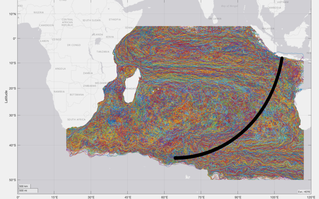
Floating debris from the crashed flight MH370 has been found and reported to the authorities in 22 locations throughout the Southern Indian Ocean (SIO). A total of 33 items drifted to these locations from the crash site, over a 3 year period. In a previous paper entitled “The Final Resting Place of MH370”, which I co-authored with Bobby Ulich, Victor Iannello and Andrew Banks, we analysed the MH370 flight path from Kuala Lumpur, Malaysia to a last estimated position of 34.2342°S 93.7875°E in the SIO, based on satellite, radar, weather, fuel and aircraft performance data. The purpose of this new paper is to determine the MH370 crash location using an analysis of the oceanic drift of these debris items, independently from any other data.
The MH370 crash location was 34.13°S ± 1.06° near the 7th Arc at a longitude around 93.98°E and the search area is defined as a circle with a radius of 65 nm centred on the crash location.
The updated paper can be downloaded here
Hey Richard, this is a very good analysis. Do you know why aren’t the crash longitude simulated/shared in the paper? I wonder if you could share those? Thanks!
@Joseph T,
Welcome to the blog!
The reason the crash longitude is not shared in the drift modelling from January 2021 is because when the latitude is defined together with the statement near the 7th Arc, that implicitly defines the longitude as well. The latitude was defined back then as 34.13°S ± 1.06° near the 7th Arc. The 7th Arc longitude for 34.13°S is 93.95°E assuming an aircraft altitude of 20,000 feet at the time MH370 crossed the 7th Arc.
Meanwhile the WSPR analysis has delivered a much more precise result for the crash location of MH370 at 33.177°S 95.300°E. This precision is subject to the limitations described in the note titled “A probable scenario of the final minutes of MH370” dated 17th March 2022.
@Joseph T @Richard
Drift analysis specifies latitude much more precisely than longitude. Prof. Pattiaratchi’s UWA drift analysis that led me to find and collect from local people 20 pieces of MH 370 debris specified a crash site in latitudes 32°S and 33°S. The WSPR GDTAAA crash site and search recommendation is contained within the southern portion of the UWA drift analysis and recommended search area.
Hi
I found a piece of debris in the grenadines, I have pic and lat/long. Is there any where I can submit the info?
Thanks
Drew
@Drew tibs,
Welcome to the blog!
You can submit your find information here.
We need the exact date, time and timezone of the find.
GPS coordinates of the find location are important.
Pictures of the debris item from different angles are very useful.
Any information as to dimensions and weight would be helpful.
Was your find reported to the authorities?
Here is a link to the picture https://www.dropbox.com/s/j3xftqw2jj63nwf/20220318_133417.jpg?dl=0
I believe the 5’x3′ piece to contain the forward most starboard side cabin door equipment access panel, a small duct, and a repair that was done to the skin of the aircraft. The underside of the piece was observed to be coated with manila colored insulation. The access portal cover appears to not be original to the aircraft. It was almost at the high tide line of the beach. The island is uninhabited.
I submitted my find on a form at http://mh370.gov.my/ but never heard back.
March 18th, 2022
1:34pm est GMT-04:00
Location
Isle A Quatre
St Vincent and the Grenadines
Coordinates
12°57’31.4″N 61°15’01.2″W
12.958730, -61.250320
I plotted a more accurate lat/long below, my first one was about 20 yds off the beach when I plotted it with google maps.
12.958670415296389, -61.24992126220223
@Drew Tibbetts,
Many thanks for bringing this debris item to our attention.
We conclude that it is definitely not MH370 however.
The flag appears to be original.
The traces of two security seals on the hatch also look original.
There was definitely no US flag on MH370.
We suspect it is part of a US aircraft, drone, missile or discarded rocket stage.
Upon asking about the fate of MH370, I was told in 2016, by a former contributor to Jane’s Intelligence, that MH370 was brought down by the US military stationed in Diego Garcia.
The reason was that there was a Chinese agent aboard who could not be allowed to return to Beijing with the top secret information he had.
The day after this event two US servicemen went on leave to Mahe in the Seychelles, had got drunk and started shooting their mouths off about the incident.
They were killed.
The following night the two prostitutes with them were with were also killed.
If there was a SERIOUS attempt to find parts of the aircraft big rewards would have been promptly offered to the [very poor] inhabitants of all the Indian Ocean Islands.
Why was some of the wreckage found along the African coast? Why had some pieces of wreckage been submerged longer than others?
Why did the captain have the route to Diego Garcia on his flight simulator on his home laptop?
Australia has wasted millions searching for a wreck that’s nowhere near her shores.
@Cherry White,
Welcome to the blog!
Do you have any evidence for your claim that two US servicemen and two prostitutes were killed in Mahe in the Seychelles? This presumably happened in 2014. Why did the former contributor to Janes only reveal this in 2016? In a search of Janes Defence I found 105 mentions of MH370, but no mention of Diego Garcia. Why was this information not made public?
The Seychelles News Agency has no report on these alleged killings in 2014, 2015 or 2016. They do report on 22nd September 2016 the Seychelles’ authorities investigated the deaths of two American women who were found “unresponsive” in their hotel room. The two sisters, aged 38 and 42, were on holiday in the island nation and were staying in a villa at the Maia Luxury Resort and Spa, on the western side of the Seychelles main island, Mahe. There are no reports of US servicemen being found killed.
You ask: “Why was some of the wreckage found along the African coast?” The answer is that it drifted there with the South Equatorial Current. There are a number of studies by Oceanographers that show how items of floating debris can drift from the MH370 crash location to the eastern shores of Africa.
You ask: “Why had some pieces of wreckage been submerged longer than others?” The same studies show that it can take varying times up to 3 years to reach the eastern shores of Africa from the MH370 crash location depending on the eddies and gyres encountered en-route, typically between 508 days (16.7 months) and 1,056 days (34.7 months).
You ask: “Why did the captain have the route to Diego Garcia on his flight simulator on his home laptop?” Microsoft Flight Simulator includes the airport at Diego Garcia as a standard part of its product. The captain could not possibly have known in advance that a Chinese agent was going to be on board MH370, therefore your question about the inclusion of Diego Garcia in the standard Microsoft Flight Simulator product is irrelevant in this context.
Finally you state: “Australia has wasted millions searching for a wreck that’s nowhere near her shores.” I have published data from four independent sources (Boeing, Inmarsat, Oceanographers and the WSPRnet) that MH370 crashed in the southern Indian Ocean at 33.117°S 95.300°E. This location is in the Melbourne Flight Information Region and approximately 2,000 km West of Perth, Australia.
Australia was asked to lead the search by the Malaysian Government because the wreckage is nearer to her shores than any other country. It is important to find the cause of the MH370 crash for the next of kin, the aviation industry and the flying public. The funding of the search for MH370 has totalled USD 223M including Malaysia $91M, Ocean Infinity $70M (no cure no fee), Australia $46M and China $20M. A new Boeing 777-9 costs $442M to buy. The insurers Allianz have stated “The insured market loss on the aeroplane is about $350m, which include the costs for searching.”
make clones of a piece of debris with the same weight, mass, density, buoyancy and smoothness fitted with a waterproof transponder. helium filled containers may be added to compensate for the change in parameters. place clone in the center of the search area on the same date of the year. and time that mh370 is assumed to have crashed. track clone periodically noting the coordinates when it ends or drifts nearest the location of the original’s discovery Adjust the coordinates of the search area center with the change in coordinates between clone and original.Repeat the operation and
trust you will reap better results in the next 11 years.
@Jan Taal,
Your idea to make a clone of a piece of debris has been done already, but not to the extent that you suggest.
David Griffin and Peter Oke of the Commonwealth Scientific and Industrial Research Organisation (CSIRO) were appointed by the Australian Transport Safety Bureau (ATSB) to study the drift of MH370 floating debris, as part of the official investigation.
The first item of MH370 floating debris was found on Reunion Island on 29th July 2015:
https://www.dropbox.com/scl/fi/2r5eesx7rvhgwp5c5tyqj/MH370-Flaperon-when-found-on-Reunion.png?rlkey=x1urbc298tqtztoex74pi8elm&dl=0
In 2017, CSIRO took an actual Boeing 777 Flaperon and cut it down to size to match the damaged MH370 Flaperon and fitted it with a GPS tracking device:
https://www.dropbox.com/scl/fi/jji8qbspa0aokc2yxzuxg/Replica-Flaperon.png?rlkey=bo2fhfr15ll0j8hyvhbb5wxoq&dl=0
They then ran tank testing to compare its buoyancy with that of 9M-MRO’s Flaperon, as well as drift testing near Hobart, Tasmania re-running the drift model and analysis of simulated trajectories.
They did not run drift testing in the Indian Ocean from the 7th Arc and suspected crash locations for 508 days to see where the replica Flaperon ended up.
@Jan Taal
The truth is, NO government wants MH370 found. The fact that all of the governments involved have steadfastly ignored every suggestion and/or request to even consider (let alone seriously consider) seeding realistic drift samples, instrumented for satellite tracking, on the 7th arc, on even one, let alone every anniversary, over the years, speaks volumes to their fervent wish to just let MH370 rest.
Richard mentioned the CSIRO flaperon tests off the east coast of Tasmania. You have to understand that these tests were only designed to see how the flaperon floated, flipped over, and drifted relative to the wind, so as to better calibrate the CSIRO drift model that was in use at the time. These tests certainly were no doubt useful for the intended purpose, but we have to remember that they were conducted in a very short test time window, in sheltered waters close in-shore, where the swell wave and wind conditions were not representative of the full range of conditions that the Reunion Island Flaperon experienced over it’s 508 day odyssey across the Indian Ocean.
If any government was serious about ACTUALLY finding MH370, as opposed to pretending to, or simply just watching and hope that OI does, what they should have done was pretty much as you suggested.
My version of your basic idea is that 5 ‘suitably instrumented representative samples’ of the recovered debris, should be seeded along the 7th Arc this year, on 9th March 2026, at EACH of the following locations: 40S, 38S, 36S, 34S, 32S, 30S, 28S and 26S. That is eight locations, five items at each, equals ’40 suitably instrumented representative samples’ in total.
They can all be dropped quite easily, cheaply and safely, at low speed, at low level, out the back ramp of an RAAF C-17 or a C-130, in one flight, one mission, launching from RAAF Pearce – out to the 7th Arc – and return to RAAF Pearce. A ‘cake walk’ for any crew.
Unfortunately (and sadly) I have to say that I personally have very little confidence that OI will be successful in their current 55 day operational search, because the current priority search area on the segment of the 7th Arc between 32S and 36S has essentially been chosen based on the basis of computer drift modeling, which are burdened with what I perceive to be an unnecessary fatal flaw, and that is, that those models have very little of what I will call ‘real representative debris fidelity’.
Every good computer model of ‘anything’ has to be ‘calibrated’ with ‘representative data’. If you don’t have ‘representative data’, you can’t have any serious confidence in the model’s output(s).
If we had drift data from ‘a fleet of representative drifters’ (as above), I might be far more optimistic than I am right now.
There has never been any reasonable excuse not to seed the arc with representative drifters, at least since 2019 (after the failed Ocean Infinity Search of 2018).
Will governments finally ‘bite the bullet’ if this current OI search fails ?
Unfortunately, I doubt it.