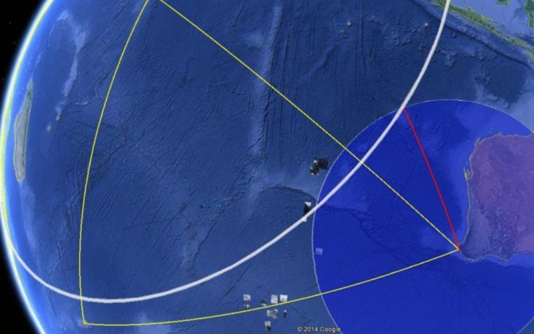
The Australian Government operates a Hydrophone Station HA01 at Cape Leeuwin as part of the Comprehensive (nuclear) Test Ban Treaty Organisation (CTBTO) verification program, which continuously monitors sound propagated through the Indian Ocean.
Staff at the US Los Alamos National Laboratory (LANL) decided to investigate the CTBTO data arriving at Cape Leeuwin because they thought that the impact of MH370 in the Indian Ocean “might have been detectable, but perhaps not easily noticed” in the recorded sound signals. The kinetic energy of a B777 impact at a speed of 490 knots is about 5.6 GJ, equivalent to about 1.3 tonnes of TNT.
A note describing the Hydroacoustic Data from HA01 can be downloaded here
@Sid Bennett
I have included 3 guest papers in the Archive in the Hydroacoustic Analysis section from Richard Stead, Ed Fenimore and Tom Kunkle of the Los Alamos National Laboratory.
They argue the case that MH370 is to be found at 40.4°S near the 7th Arc.
Does 5.6GJ apply to a nose down dive that would have cause total disintegration of the plane, or to a controlled flaps down ditching? What would be detectable by the Hydrophone Station in the latter scenario?
@Andrew,
The 5.6 GJ impact was a nose down dive of MH370 a Boeing 777 with a zero fuel weight of 174,369 kg at 490 knots.
A controlled ditching at a typical landing speed would be less than 30% of this energy and not detectable.
@All,
I have received a message from a reader regarding the declassified report of the location of a Soviet submarine that exploded and sank in 1968:
“In the 60’s the American intelligence located a Russian submarine that exploded and sank without trace.
Using underwater microphones they triangulated its position after studying recorded data collected from this audio technology.
Howard Hughes and the Glomar Explorer attempted to raise it from the depths.
Isn’t it possible that new technology might have recorded the impact of MH370 and its location?
It worked 50+ years ago, nothing to lose if it still exists.”
The submarine was located at 38° 5′ N 178° 57′ E by using triangulation of audio recordings from several SOSUS stations.
The Sound Surveillance System (SOSUS) was a submarine detection system based on passive sonar developed by the United States Navy between 1949 and 1954 to track Soviet submarines.
U.S. SOSUS naval facilities in the North Pacific had been alerted and requested to review acoustic records on 8th March 1968 to identify any possible anomalous signal. Acoustic data from four Air Force AFTAC sites and the Adak, Alaska SOSUS array triangulated a potential event location to within 5 nautical miles, a site hundreds of miles away from where the Soviet Navy had been searching and in water around 16,500 feet (5,000 m) deep.
Upon examination, it produced sufficient triangulation by lines-of-bearing to provide the U.S. Navy with a locus for the probable wreck site. One source characterised the acoustic signal as “an isolated, single sound of an explosion or implosion, a good-sized bang”.
Acoustic data may also be used to detect MH370 by triangulation of recordings on 8th March 2014 from three sites in the Indian Ocean operated by the Comprehensive Test Ban Treaty Organisation (CTBTO):
HA1 Cape Leeuwin, WA, Australia.
HA4 Crozet Islands, France.
HA8 Diego Garcia, British Indian Ocean Territories, UK (leased to USA).
To my knowledge only data from HA1 has been analysed so far. Data from HA4 and HA8 has not been analysed in conjunction with the data from HA1.
First Question:
This hydroacoustic data analysis is another subject that has been troubling me for quite some time. Based on the WSPR analysis, we now have a reasonable timeline of events. Presumably this timeline would include the approximate time of the controlled ditching. (within a 10 minute window perhaps???)
Now….. knowing the location of the ditching, AND the time window of the ditching… and factoring in the speed of sound in ocean water plus the distance to HA1, it seems to me that carefully looking through the acoustic data from HA1 within a very small window (10 minutes???) should provide some small degree of results / success. Am I hoping for too much?
Second Question:
Does anybody know why the hydroacoustic data from HA4 and HA8 not been scrutinized in the same manner as I just laid out above for HA1?
Here’s what I’m pondering:
If we know the time & location (thanks to WSPR) … and we also know the distances to each hydrophone, we should be able to retrieve some useful information from this hydroacoustic data. Sure, there is a mountain of hydroacoustic data to weed through… however, knowing the approximate location where the plane entered the water SIGNIFICANTLY narrows the time window of the acoustic data analysis. (Small adjustments to the calculations for the speed of sound based on salinity and temperature could be factored into the arrival time at each of the three hydrophones.)
Do you have any thoughts on this Richard? Am I oversimplifying the difficulty involved?
Thanks,
Martin Reiss
Hi Richard,
The CIA ran the K129 recovery program under the codename project Azorian. There is 2 part BBC documentary that is worthwhile viewing. It goes into some of the engineering involved.
Hollywood could not have made this up. It involved Howard Hughes, Kelly Johnston skunk works & Lockheed.
@Martin Reiss,
A nice idea but …
The Australian Government operates a Hydrophone Station HA01 at Cape Leeuwin as part of the Comprehensive (nuclear) Test Ban Treaty Organisation (CTBTO) verification program, which continuously monitors sound propagated through the Indian Ocean. There are three sensors colocated at Hydrophone Station HA01 that allow a degree of triangulation of the location of the source of the hydro-acoustic disturbance. Recordings of low-frequency underwater acoustic signals from data loggers and hydrophones off the Western Australian coast (these hydrophones are located in the Perth Canyon to the west of Rottnest Island) were retrieved and analysed by Curtin University’s Centre for Marine Science and Technology during the search for MH370. The ATSB requested the Curtin University Centre for Marine Science and Technology (CMST) and the Defence Science and Technology Organisation to analyse these signals in an attempt to detect and localise underwater sounds that could be associated with the impact of the aircraft on the water or with the implosion of wreckage as the aircraft sank. This analysis was inconclusive.
Unfortunately data from the Comprehensive Test Ban Treaty Organisation (CTBTO) hydroacoustic data from station HA08 Diego Garcia, British Indian Ocean Territories / Chagos Archipelago is missing for 25 minutes around the time of MH370’s impact, which would have allowed a better triangulation with the data from station HA01 Cape Leeuwin, Australia and the data from station HA04 Crozet Islands, French Southern and Antarctic Lands. The HA08 data has not been released by the US Government under their treaty obligations and the British and French Government have acquiesced. The HA04 has also not been released by the French Authorities.
Without the HA04 and HA08 data your idea is severely restricted in its usefulness.
Thanks for the information Richard.