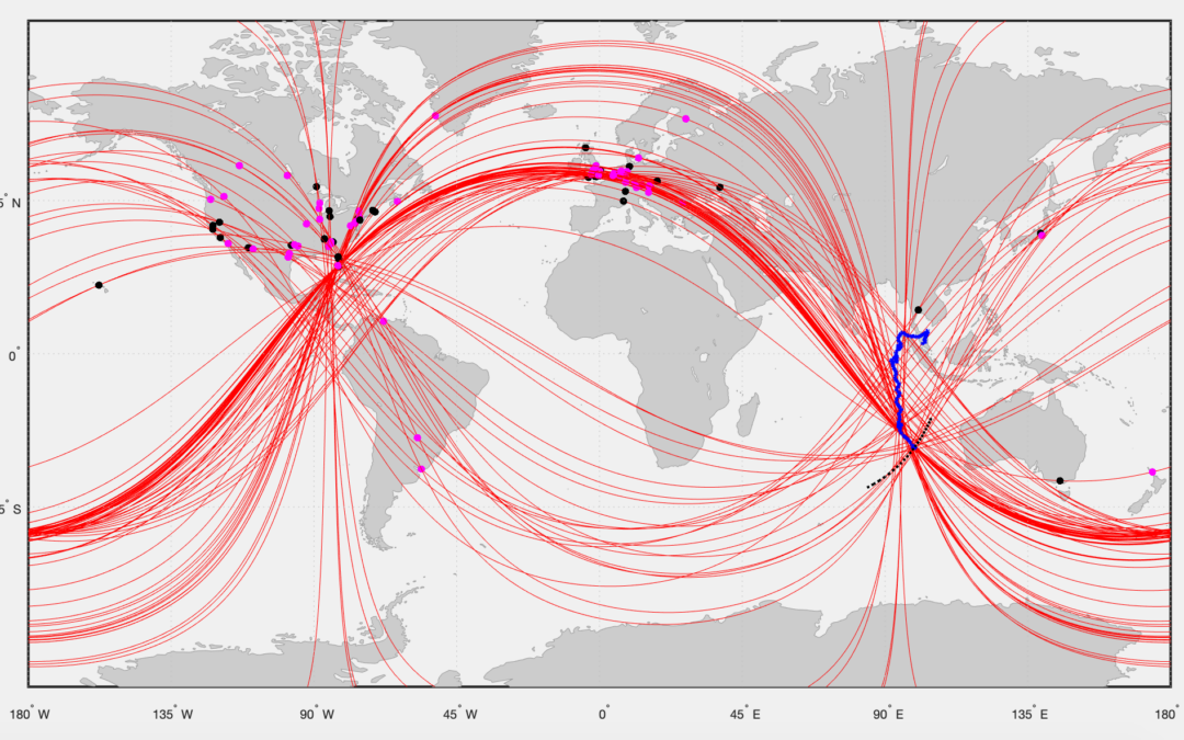
WSPRnet radio signals can reliably detect and track aircraft over long distances to the other side of the globe. Anomalies in the WSPRnet data, in either the received signal level, or received frequency, or frequency drift indicate a possible disturbance by an aircraft.
WSPRnet is a multi-static and multi-frequency system with global coverage. There are currently around 6 million distinctive links between WSPR transmitters and receivers from around the world with a propagation distance greater than 3,000 km recorded in the WSPRnet database.
The long coherent integration time of the WSPRnet receivers, the enhanced radar footprint of modern aircraft in the WSPRnet wavelength bands and the global coverage of WSPRnet propagations ensure a high level of detection and reliable tracking of aircraft.
The WSPRnet technique is, in its simplest form, statistical post processing of the meta-data from a communications link. We combine the reflection of radio waves by aircraft as used in radar, with ionospheric propagation and the WSPR protocol to detect and track aircraft over long distances.
This technique was used to track MH370 from the last confirmed radar detection on 7th March 2014 at 18:00 UTC until the end of flight on 8th March 2014 at 00:28 UTC. A total of 313 anomalies in the signal level or frequency of the WSPR signals were detected at the estimated position of MH370 at 130 different points in time.
The crash location of MH370 was at 29.128°S 99.934°E, which is outside the previous ATSB and Ocean Infinity underwater search areas.
A technical paper describing the WSPR technique for detecting and tracking aircraft over long distances can be downloaded here
Dear Richard,
Congratulations on the impressive work on aircraft tracking using the WSPR network. I work in a different academic field, so the technicalities of this are lost to me, but I have learned a great deal from your website and papers, nonetheless.
Chapter 5 in the paper titled “How does WSPR detect Aircraft over long Distances?” displays the highly impressive reconstruction of a flight path using WSPR data. This has been done on an airplane that took off and landed safely, flight THY161. In the case of MH370, the community is looking for an airplane that did not land safely, moreover, is lost in the ocean.
My question to you:
Have you considered testing the WSPR data on Air France Flight 447 (AF447/AFR447) which on the first of June 2009 crashed into the Atlantic Ocean? The plane has been recovered and the crash location is known.
Kind regards,
Petra
Did anyone consider this yet?
@Petra,
WPSR only started in late 2008. When the AF447 crash happened in 2009, WSPR was in its infancy with very little data available.
Meanwhile we have used WSPRnet data to track thousands of aircraft all over the globe.
Can the WSPR / GDTAA software detect clear air turbulence, ie does clear air turbulence create detectable anomalies in signal transmission / reception patterns that could be used to relay weather warnings to pilots in real time?
“Scientists say that clear air turbulence, which is invisible to radar, is getting worse because of the climate crisis.”
https://www.theguardian.com/world/article/2024/jul/01/air-europa-plane-turbulence-injuries
Any practical application of the WSPR / GDTAA software would help to raise its profile worldwide, and this in time might help to persuade the relevant authorities to permit searches for MH370 in the areas where it is most likely that it crashed.
If it hasn’t happened already, it might be worth reaching out to the ITF (The International Transport-Workers Federation), as they were very helpful in locating the wreckage of the MV Derbyshire, after many years of corporate and governmental obfuscation.
Part of the problem for MV Derbyshire was the quality of weather forecasts that it relied on.
“The cause of the sinking was only established 20 years after the tragedy. The lack of wreckage or survivors initially impeded a formal investigation by the British government and Typhoon Orchid was established as the official cause of the sinking.
After several years of campaigns by unions and victims’ relatives under the “Derbyshire Families Association” for the official opening of an investigation into the causes of the accident, as well as two separate incidents of deck plating (frame 65) cracking in two of Derbyshire’s sister ships which unveiled flaws in design modifications, ITF funded a deep-water search mission to find the wreck, which was eventually found on 8 June 1994 off Okinawa, Japan and led to the reopening of the case.
Following two expeditions, the initial investigation outcome in 1998 was that the ship sank because the lid to a store hatch on the fore deck had been left unsecured, thus attributing the incident to crew negligence. After several years and conflicting theories as to what led to the sinking, the official cause was announced in 2000 and was traced in design flaws, noting that rough seas damaged the vessel’s deck fittings and hatch covers, subsequently leading to the chain locker, forecastle and then the cargo holds being flooded one by one, sinking the ship in less than two minutes.
Due to the use of a flushed deck, rather than the fitting of a more conventional forecastle, the mountainous waves caused by Typhoon Orchid were allowed to sheer off the covers of small ventilation pipes near the bow, which, over the next two days, caused seawater to enter into the forward ballast section of the ship and draw the bow slowly into the water.
As the bow dropped lower in the water, the sea started damaging the first hatch cover, which was not designed to withstand such conditions and flooded, opening the way for the others to flood too and eventually sinking the ship. In this final version, there was neither evidence that crew was responsible for leaving hatch covers open nor that the deck plating was flawed.”
https://safety4sea.com/cm-mv-derbyshire-remembering-largest-british-ship-ever-lost-at-sea/
@TommyL,
Detection of severe weather events is improving, but climate change has been shown, by studies like the one from Reading University mentioned in the Guardian article you linked, to be the cause of an increase of turbulence on long haul flights.
On 21st May 2024, SQ321 suffered a sudden drop of 6,000 feet over the Andaman Sea and had to divert and make an emergency landing in Bangkok with one person dead and several other passengers and crew injured and suffering skull, brain and spine injuries.
A week later, eight people were taken to hospital after turbulence during a Qatar Airways flight from Doha to Ireland over Turkey.
On 1st July 2024, an Air Europa flight from Madrid to Montevideo dropped 3,000 feet suddenly and was forced to make an emergency landing at a Brazilian airport due to “severe turbulence” over the Atlantic Ocean.
As you mention radar cannot detect clear air turbulence. ADS-B data transmitted by the aircraft can record the sudden change in altitude and rate of descent.
Radar with a pulse width of typically around 1µs cannot detect the change in aircraft altitude caused by turbulence. WSPR integrates the received signal over 110.6 seconds and can detect the effect of turbulence on the aircraft. WSPR cannot forecast areas of turbulence, it can only detect the effect of turbulence on aircraft.
Re:”WSPR cannot forecast areas of turbulence, it can only detect the effect of turbulence on aircraft.”
Thanks Richard,
It looks as though you are saying that WSPR can only identify clear air turbulence after an aircraft has encountered it, which would, of course, be of no use as a warning system.
From what I’ve read on this blog over time, my understanding of the way WSPR data is used for aircraft tracking is that anomalies in the timing between transmission and reception can arise when a radio signal is
1. reflected off the surfaces of an aircraft
2. disturbed by the heat and exhaust from the engines
3. disturbed by the turbulence caused by the aircraft as it moves through the sky
What I was wondering was whether clear air turbulence on its own would be capable of creating detectable radio signal anomalies.
While WSPR alone may not be sufficient, might WSPR analysis be able to play a part in the development of a real time turbulence locator mapping system (ie not so much as a means of ‘predicting’, more as a means of identifyiing, locating and tracking areas of unusually high turbulence, whether in clear air or not.
While on the subject of weather radar warning systems, there is a recent entry in the maintenance log of MH370 that appears to refer to the weather radar system.
It might be another piece of equipment which, once the wreckage is located and recovered, will help to make sense of what happened to the aircraft.
Below is an extract from item 35 in the recent technical log entries (Appendix 1.6A) in the MH370 safety report
“S/N 4880484
– 02 March 2014
Status mssg WXR sys
02 March 2014
MMSG: 34-44002.
WXR transceiver (right) has an internal fault.
MSG erased from maintenance page.
WXR (R) CB (P11/E16)
Nil existing faults.
Pls eml and report.”
Somewhere I came across a suggestion that the Agilent measurement equipment being transported on MH370 was an NMR Spectrometer.
Would this type of equipment, or for that matter the large consignment of Motorola walkie talkie accessoroies, be capable of responding to electromagnetic pulses in a way that could be detected by an underwater search vessel?
After ten years on the ocean floor, could any of these components, or the aircrafts own electrical hardware still respond detectably to such an electromagnetic “ping”.
Have previous searches already scanned for such ultra weak induced signals? If not, is there any potential for localised underwater wspr?
Hi Richard
After accidentally seeing TV program about MH370 with you mentioning using WSPR to track the potential crash site, I was intrigued how can this be and Googled this website and read through your WSPR papers from August 31, 2023 and February 2024.
I am myself amateur radio operator and have spent about 30 years on short waves (30 MHz and below), so I know a little bit how the airwaves sound and how the propagation works.
I have general question about criteria you use to decide, what WSPR reports are relevant to track the specific flights and which are not. You seem to consider all WSPR reports around the world, even if both transmitter and receiver are located “on the other side of the globe”, and you assume that signal is able to travel to Indian ocean from another side of the world and then back (or continue straight) to the other side of the world again without this signal fading to unreadable or ignorable levels during this travel.
Let’s take as an example, the first specific WSPR report you mention in August 31, 2023 report as being relevant (Section 5. Worked Example. https://www.dropbox.com/scl/fi/nn3eedtd9ew15f81n2xx7/MH370-Flight-Path-Analaysis-31st-August-2023.pdf )
Receiver in USA/NY state (N2NOM) received WSPR transmission from Greenland (OX3XR) at 22:42 UTC.
Data from wspr.live confirms this report happened, transmit power 33 dBm = ~2 Watts, 10 MHz band.
My question is: why do you assume that this signal reception done in USA East Coast from low power transmitter (2 Watts on short waves, 10 MHz band is really not much) in Greenland was somehow influenced by flight MH370 flying somewhere over Indian ocean ~13 000 km away? Direct distance between Greenland and USA/NY receiver is about 3000 km.
I see it much more trivial way – WSPR signal arrived to USA straight from Greenland traveling these 3 000 km.
And all Signal To Noise deviations are well inside the margin of error and can be explained by typical local variables, like ionospheric instabilities, changing local atmospheric noise (thunderstorm crashes), intermittent interference from other radio amateur transmissions on nearby frequencies, including other WSPR transmitters sharing the same 2.5 kHz bandwidth and contributing towards the noise floor for other WSPR signals, and other variable human made noise (not so EMI rules compliant consumer devices in neighborhood switched on and off).
Or, if you wish to bring airplanes into equation, then you should probably consider possibility that signal is bouncing from any of numerous trans-Atlantic flights between Europe and North America over Greenland, which are in direct signal path in this case, not like MH370 which is 13000 km away.
If you follow my logic, then I am afraid there will not be many WSPR reports left to be considered at all in context of MH370. Because there are not too many short paths which cross the Indian ocean in the area of interest. Africa is quite deserted when it comes to amateur radio and WSPR receivers. Antarctica – you know, as well. Basically only Europe-Australia/New Zealand path can be interesting, as there were some WSPR receivers and transmitters on both ends, but i am afraid there will be close to 0 reports like that, due to the low power of WSPR transmitters and, as i mentioned, signal energy losses in Ionosphere accumulating from every bounce between Earth and Ionosphere.
I checked randomly and manually WSPR data for March 7, 2014 23:50, 23:52 UTC in wspr.info and there were 0 (zero) WSPR reports where short path crosses the area of interest in Indian ocean. Sorry.
And even if you would find 10-20 reports where short path crosses the area of interest, i doubt you could draw any meaningful conclusions from such small amount of data.
All this is even after making another brave assumption that single distant aircraft can noticeably influence the signal strength on such direct, but long distance path involving multiple hops (signal bounces back and forth between Earth surface and Ionosphere).
I would love to see the outcome of scientific study, which was announced in the TV program i watched, and which promised to verify the usability of WSPR data for radar-like use-cases.
Best regards,
Peter
@ShalomMASIH-z1z
hey Richard My question is if debris that found earlier is confirmed came from mh370 passenger cabin that indicates that plane shattered so why the flapperon so intact when it’s also confirmed that it’s came from mh370
@Shalom MASIH,
Welcome to the blog!
In my view, the aircraft neither shattered into a million pieces, nor remained intact like US Airways flight 1549 on the Hudson River.
The flaperon, if retracted, is protected to a large extent within the wing structure close to the fuselage.
The flaperon, if extended, has a rigid mode and an elastic mode. In the rigid mode the trailing edge would be ripped off on impact with water. The flaperon found on Reunion had its trailing edge ripped off. It was not as intact, as you indicate.
@Peter,
Welcome to the blog!
You raise a large number of questions about the utility of WSPRnet data in detecting and tracking aircraft like MH370, transmission power levels and losses, distances, short and long transmission paths, SNR deviations, other aircraft, data volumes and ongoing studies.
Here is my response to your comments and questions:
https://www.dropbox.com/scl/fi/18cnspp9ji6iniufqejaa/Comment-Peter-22MAR2025.pdf?rlkey=r32b0s00vk14ykhs4uro6vwi3&dl=0
Hi Richard
Thank you for very fast and detailed reply. Wow!
I have the following more to say in reply:
1. WSPR is weak signal mode, true. But it has its limits. -34 is mentioned as the lowest SNR value in Wikipedia https://en.wikipedia.org/wiki/WSPR_(amateur_radio_software)
From reports done by N2NOM receiver for OX3XR transmissions provided in your August 30, 2023 paper on page 168, those reports are always towards the lower end of reception scale (all below -20).
Do you think that reports for other times before and after 22:42 UTC, which you do not consider anomalous, between N2NOM and OX3XR happened short path? If so what’s your explanation that even with generally weak short path (2885 km) reports, 11 times longer path (~32000 km in total from Greenland to MH370 and back to state of New York) involving assumed MH370 location still was able to make any difference?
2. Sorry, but I fail to find an answer to the question I asked. Why do you think that this WSPR report between Greenland and state of New York in USA (distance 2885 km as you say) was influenced by MH370 airplane 17454 km away, where total distance for signal to travel your suggested path would be around 32000 km.
Mentioning communication to Voyager spacecraft and distance to it is not relevant in my opinion. It is like saying that you can throw a ball on Earth 1000 km, just because someone in outer space can throw it and it will fly 100000 or more km there. Communication from Earth to Voyager in outer space is involving… outer space, to start with, and it is happening in completely different frequency range – 2 to 8 GHz (https://en.wikipedia.org/wiki/Voyager_1). Signals in GHz range are not reflecting from ionosphere like short wave signals do. GHz signals penetrate Earth ionosphere only once before leaving to outer space. And then in outer space GHz range of signals have no more Earth ionosphere attenuating layers to pass through, in contrast to long distance short wave signals on Earth bouncing back and forth between Earth surface and ionosphere and getting weaker and weaker every time they reflect from upper ionosphere layers, pass through the lower attenuating layers of Ionosphere (like, D and E layers).
Regarding great circle paths on the map: can you confirm, that when drawing paths on the map you always assume that WSPR signal is capable to circle the globe (infinitely?) and ignore the attenuation incurred by signal on every hop? Or may be you can point me to the part of your paper where this attenuation is being considered to narrow down the list of MH370 relevant reports? I see that you are considering MUF, but not attenuation.
3. -33 report at 22:42 UTC does not seem to be very anomalous, you can also see -31 about half an hour later for the same pair of receiver/transmitter. So, it happens, as I see it, even without MH370 being in certain position.
4. Yet again you seem to disregard the short path possibilities. If we are considering potential influence to WSPR signals by flying airplanes, what if signal from Greenland (OX3XR) towards state of New York (N2MOM) got reflected by some airplane close to the receiver location, which is ~300 km North from the busy New York airport?
Where the elevation angle of 2.99 degrees comes from? Even decent short wave amateur radio antennas have the radiation pattern with significantly higher elevation angles of the main vertical lobe, thus more hops would be needed to achieve the same distance, compared to your calculation, and more attenuation would be incurred by the signal due to more hops. Is this 2.99 degree angle calculated to satisfy requirement for path to cross assumed MH370 location on vertical plane?
Bear in mind, that antenna is not radiating just at this single angle and nowhere else. Antennas have radiation pattern with lobes with some beam width both in vertical and horizontal plane Over 10…20 degrees at least for short waves, or more, depending on antenna type, often omnidirectional antennas are used. So you can not just say, that because there are no airplanes in 3 spots in the world (Murmansk, Tajikistan, Bay of Bengal) calculated using precision of 0.01 degree elevation pattern, thus only MH370 could influence the signal. Antenna radiation in other angles (both horizontally, and vertically) will get reflected by ionosphere to different spots on the Earth surface, and thus your search for potential airplanes to be considered as part of equation extends a lot.
5. Looking forward to see what Liverpool University comes up with. As can be seen above, I have certain doubts about the methodology you have used.
Best regards,
Peter
As a follow up, I extracted WSPR reports for a period of 2014-03-07 17:00:00 and 2014-03-08 01:00:00 UTC.
And in this data I was able to find 26 WSPR reports with relevant short path reports crossing Indian ocean for the whole period of 8 hours.
It consists of South of Europe vs Australia, West Australia vs Europe, few Israel vs Australia on 7 and 14 MHz bands, which is just indication of quite regular European evening propagation towards Australia.
26 reports in 8 hours is before applying any further filtering to distinguish “anomalous WSPR reports”, which would need to be done to search some signs of potential airplane influence on these reports.
I think it is quite evident, that you can not draw any conclusions from such small dataset, even if such conclusions would be theoretically possible, which I doubt about either.
@Peter,
I have answered all your questions in full.
We will have to agree to disagree on the utility of WSPRnet data to detect and track aircraft.
Have individuals been tracking ocean debris following the wreck, and for how long can debris remain afloat?
@Heidi Conway,
Welcome to the blog!
We have found 43 items of floating debris, either likely or confirmed to be from MH370.
Floating debris can stay afloat forever, as long as it does not get water logged and retains a sealed enclosure with air trapped in it.
For example the world record for a message in a bottle is held by a lady from Australia, who found a bottle 132 years after it was thrown into the sea.
You can see the bottle and the message in the Museum of Western Australia in Perth.
https://www.dropbox.com/scl/fi/sy3hndtesmg3hu9l0wdnl/Message-in-a-Bottle.png?rlkey=g7ltxj87ark9qrmur9y1rcgvs&dl=0
The bottle was one of thousands thrown overboard in an experiment conducted by the German Navy over a 69 year period, involving all their ships around the world. 662 messages were returned to the German Admiralty, from all over the world. The world record message in a bottle was from the sailing ship Paula and thrown overboard on 12th June 1886 on a voyage from Cardiff, UK to Indonesia. It was found on 21st January 2018 by Tonya Illman, around 100 miles North of Perth.
The museum analysed the ship’s records and the Captain’s handwriting and it was the same as the message in the bottle.
https://www.dropbox.com/scl/fi/ymvyxxx9su79vozzn892a/Message-in-a-Bottle-Analysis.png?rlkey=2une295qm3jcmsw6n9mim4mhz&dl=0
@Peter,
Here is my response to your many questions, comments and doubts (13.4 MB, 25 pages).
https://www.dropbox.com/scl/fi/yp88whu634j0x6yykijop/Radio-Amateur-s-Questions-and-Answers.pdf?rlkey=391mvartgtm41pipasdb9cbi3&dl=0
Hi Richard
Sorry, i am not getting away 🙂
Thank you again for extended reply.
I will start with the most important – thank you for pointing to the path loss calculations on the top of Proplab ray tracing chart.
If I read it right, signal level halfway (upon signal arrival from Greenland to the assumed location of MH370) was -208.68 dBm. The best noise floor of the best amateur radio transceivers in 2025 is -145 dBm (http://www.sherweng.com/table.html). This would give us WSPR SNR of -67 at location of MH370. Can such report be in real life?
Here is distribution of all WSPR reports by SNR in year 2025 so far, where SNR is below -34 :
SNR Count_of_reports
-35 5040
-36 4744
-37 4143
-38 3690
-39 3368
-40 2722
-41 1763
-42 856
-43 259
-44 70
-45 30
-46 20
-47 12
-48 8
-50 3
-51 1
-53 1
-55 1
-99 20
I think -99 is some kind of glitch in the matrix. So -67 (with great gap) never happened in first 2.5 months of year 2025, including March 7-8.
And this weak signal is just halfway distance of the total 32000 km. Now these remainders of signal need to be reflected/scattered by MH370. Airplane is not active signal repeater, it is not repeating or amplifying the signal, at best it is just scattering/reflecting what’s left of the initial signal (it is certainly not initial 2 Watts again “flying” back). And then these reflected/scattered bits and pieces need to travel back (or forth?) from Indian ocean to state of New York incurring ~same amount of further losses. Unreadable weak signal gets even weaker.
More over, this is with Proplab calculating losses for path with too few hops, due to some far from real antenna pattern assumption, where antenna in Greenland radiates with 2.99 degree vertical elevation angle. I pointed you in last message that antenna pattern with such elevation angle is far too good even for the best of amateur radio antennas on 10 MHz band. I failed to find the good reply from you on this, just found some general classification of antenna types.
Seems that this proves my point – that this long path signal travel could not happen on that band, in that time of the day with such antenna and such power.
If you base your MH370 location search on irrelevant WSPR reports like these, it isn’t right i think.
In your reply I didn’t understood what amateur radio transmitter with 2 Watts of power and omnidirectional antenna has in common with DoD Wide Aperture Radar Facility (WARF) with at least 1 kW of power (as you mentioned). The name Wide Aperture Radar already tells that their antenna was more effective, directional and providing huge amplification effect in a desired direction for initial big enough 1 kW of power. No wonder they can send their signal around the globe as they wish, yet may be still they chose appropriate frequency and time of day, i am not aware of that.
Explanation why -33 is considered SNR anomaly, despite there is -31 report half an hour later didn’t convince me. Argument that -31 is not anomaly because there is no 2nd anomaly somewhere else coinciding with it, isn’t strong in my opinion. May be 2nd anomaly (G3JKF) is rather “normal” too if you look around? If you mention it – why exactly you call G3JKF at 22:52 anomaly and put red rectangle around it in MH370 report? -3 report seems totally OK, 6 minutes later there is -4. -13 before that is a bit off, but half an hour later there is -9. So again – nothing too out of normal.
WSPR SNRs tend to be unstable, floating, jumping, I have tried WSPR, and I have tried other digital modes too. If you search in large dataset, what you keep saying WSPR report dataset is, without careful examination of what is relevant, you might come across 2 jumping SNRs and even crossing lines close to location you are investigating.
Also I didn’t find convincing explanation why you are not considering any other airplanes flying if not all around the world, then at least departing/approaching New York airport in proximity of receiver (300km away from airport). As I explained, antenna is not radiating in a “needle” like pattern in one angle with 0.01 precision, like some kind of laser beam. Short wave antennas have wide beamwidth or even omnidirectional, as you say in this case was, thus much more airplanes can cause anomalies, if you believe they do. And if they do cause anomalies, I would first consider those airplanes which are in ~line of sight of receiver or transmitter or somewhere one hop distance away, where the signal is strongest, thus reflections will be stronger and will cause larger deviations from normal baseline.
For reference:
I believe and know that long path propagation exists, and signals can even make a whole circle around the globe sometimes, I have experienced that myself (long path is not that rare with right conditions, full circle is rare). But signal traveling around the globe is rather rare exception where many things must align (right band, right Solar activity, right time of the day in the right place of the world). You can not take it for granted that it always happens on any band, day and time, just because some 2 local stations have a local propagation somewhere between them, doesn’t mean that signal will travel all around the world. And especially with 2 Watts and omnidirectional antenna.
I also know that signals on higher frequencies can reflect from objects, like airplanes, and even meteorites – (meteor scatter propagation), however this usually is used on higher frequencies (>= 50 MHz), with short burst modulation types, and not beyond 1 hop as far I have heard (I am not doing this thing myself). Internet tells that even short wave Over-The-Horizon radars, dedicated for similar purpose of detecting object location/movement, with huge power and antennas, still max range is 3000-4000 km.
Regards,
Peter
@Peter,
No one is asking you to go away.
I simply asked that we agree to disagree.
I have answered all your points in a 25 page document.
Repeatedly asking the same questions or making the same points, shows me that you are stuck in your thinking.
You state: “Unreadable weak signal gets even weaker.”
I have shown that the WSPR protocol has been received over very long distances and is designed for weak signals.
You state: “If you base your MH370 location search on irrelevant WSPR reports like these, it isn’t right i think.”
I have explained why WSPRnet data is relevant to detecting and tracking aircraft.
You state: “I didn’t find convincing explanation why you are not considering any other airplanes flying if not all around the world.”
I have explained that we check against the ADS-B data of all other aircraft flying at any one time to see if they intersect with the propagation path of the WSPR signal.
You obviously have not read the paper I sent you or are purposely ignoring my responses to your questions.
I can’t help you.
Hi Richard
I read the paper with your answers. I am not ignoring your answers, I am just pointing you to those concerns, which your responses, despite being 25 pages long, fail to address in my opinion. I won’t repeat them again.
If you could at least comment on one last, but most significant topic, which I raised in the latest message, it would be nice. That is about your own Proplab ray tracing graph indicating signal strength well below WSPR readable levels already halfway of the total assumed signal travel distance.
No need to arrange a conversation for me. I have my radio setup at my disposal, and I know the websites where WSPR and other modulation online and historic reports and maps can be found.
If anyone else has additional arguments on the concerns I have raised, I will be glad to read them here.
Thanks for your time.
Regards,
Peter
Richard,
I have been following your WSPR discussions with Geoffrey Thomas on 3/25/25. You mention a paper which you had written titled: Questions from a Radio Operator regarding WSPR.
Would you kindly send me a weblink of a copy to read more of this new technique, ? Regards, Paul Francis, Erie, PA 16505. Thank you !
@Paul Francis,
Welcome to the blog!
@Peter is an amateur radio operator and has spent about 30 years on short waves (30 MHz and below), so he knows a little bit how the airwaves sound and how the propagation works.
You can read his comments at the following links:
https://www.mh370search.com/2024/02/15/wspr-aircraft-tracking/comment-page-2/#comment-3966
https://www.mh370search.com/2024/02/15/wspr-aircraft-tracking/comment-page-2/#comment-3975
https://www.mh370search.com/2024/02/15/wspr-aircraft-tracking/comment-page-2/#comment-3982
https://www.mh370search.com/2024/02/15/wspr-aircraft-tracking/comment-page-2/#comment-3996
Here is my response to his comments:
https://www.dropbox.com/scl/fi/yp88whu634j0x6yykijop/Radio-Amateur-s-Questions-and-Answers.pdf?rlkey=391mvartgtm41pipasdb9cbi3&dl=0
@Peter,
If you send me your call sign and let me know, which time zone you are located in, then I can arrange for conversation with another WSPR user on the other side of the world from you.
@Peter,
It is a shame that you turned down my offer to arrange a conversation with another radio amateur on the other side of the world and exchange WSPR data, you might have learned something. I was thinking of asking VK3EDW in Australia, who like many others has taken up my offer to receive a copy of all my Matlab source code and data.
You had 16 questions and I have answered all 16 questions.
Peter,
in case you would have your WSPR equipment up and running you should have noticed numerous HABs (High Altitude Balloons) at 10 to 12 km altitude), such as LU1ESY, VE3VRO, LU7DZV et al. with only 10 mW (0,01 Watt) of WSPR TX power in the SIO covering distances of thousands of km with and without aircraft forward and side scatter (SIO: Southern Indian Ocean).
Observing and studying those scattered WSPR signals in detail should make the majority of your questions and statements regarding SNR etc. obsolete?
Forward scatter of more than 10.000 km at aircraft has been observed numerous times on various days if SFI (Solar Flux Index) is appropriate.
By using the WSPR signals of HABs 1.000 to 5.000 km west of Perth you can observe distant and close (even less difficult to observe) aircraft approaches as well as overflights in the Perth region (PER).
Did you ever study the primary WSPR signals at a real physical receiver, such as VK6QS (Perth) et al. in real time and compare those WSPR signals to the results in the data base?
P.S. These HABs just send WSPR signals in local daylight as they do not have batteries due to weight constraints. No WSPR signals at night.
First WSPR aircraft flight tests have been conducted in the UK as early as 2009, 2013 with distances up to 100 km and more at 10 MHz, 50 MHz by G3JZO, G6HNU, G0MBA, G6AVK over the Irish Sea.
Partly intrigued by @Peter’s “certain doubts”, and reflecting further on other possible weak signals that might be helpful in finding and recovering the wreckage of MH370, I was wondering whether there are any accurate, publicly available databases tracking the precise location of the earth-moon barycentre over the last eighty years.
No doubt various private and government agencies and projects have this data, to ensure amongst other things, that data models, weather models, communications systems and vehicle and weapons guidance systems remain in sync with real world events, such as lunar and solar eclipses, tides etc.
Why I ask is just in case there is a way to track the impact of the take off and landing of a heavy object, like a large, fully laden aircraft, by analysing any very subtle associated anomalies in the tracked position of the earth-moon barycentre.
Such ultra-weak signals, surrounded by so much ‘noise’, might be at there most detectable particularly at times when the heavy object’s flight path was at it’s closest and most distant to the moving, sub-surface location of the barycentre, or if the heavy object took off or landed in a very remote location, such as the southern Indian Ocean.
If a ‘barycentric impact profile’ for a Boeing 777 200ER could be constructed, and mapped against historic barycentre data, it could, perhaps, be used to construct an additional layer of corroborative data for Professor Simon Maskell to work with in his evaluation of WSPR, and in his contribution to the search for MH370.
If there is any ‘mileage’ in the idea, it might prove helpful in tracking and locating any other unlawfully diverted and remotely crashed, (ie in a remote place) large aircraft in the future.
Tommy,
you are more than welcome to invest your valuable time in the research of the RBN (Reverse Beacon Network) data base (also radio amateur Network data base) as well as in the scientific SuperDARN data base at Virginia Tech.
Both data bases contain data for 7th and 8th March 2014!
For the sceptics and detractors of WSPR SuperDARN should be of special interest as it composes several “real” RADARs including electronic beam forming at the polar regions.
The Chinese ZHO in Antarctica will certainly deserve special interest as at least one or two of its 16 antenna beams is pointing towards Western Australia. HF data are available!
Sure enough due to the large distances you will have to face special challenges such as range ambiguities, skip zones, the behaviour of the ionosphere in the Antarctica region (TWDs) etc.
Anyway please feel free to get started. The appropriate data are available in the open public. Good luck!
Thanks Rob,
You might have misunderstood my question to Richard.
Essentially I was asking whether historical data about the underground, moving location of the earth-moon barycentre could usefully serve as a ‘carrier signal’ or reference signal for the purposes of improving the reliability and accuracy of any WSPR / GDTAAA system, especially with regard to the current search for MH370.
As a non-scientist, it is easily possible that my suggestion is “up a gum tree” due to some simple lack of understanding of a basic principle of physics.
However, the suggestion has been made in good faith, just in case it might be helpful to the search.
If you want to find out more about the earth-moon barycentre I found an article written by ‘Nikolay S. Sidorenkov’ by searching on Google for
earth moon barycentre “carrier signal”
The article includes an introduction to some of the complexities of the earth-moon’s rotations, oscillations and orbits in sections 2 and 3.
The title of the article is “The Interaction Between Earth’s Rotation and Geophysical Processes”.
@TommyL,
I can understand the consequences of your idea in the fields of astronomy, space geodesy, meteorology, oceanography and aerology, but not aviation.
We all know about day and night, seasons, tides, gravity, weather changes, storms, El Niño, etc.
Few us know about the inclination, nutation and instabilities of the Earth spinning on its axis.
When we threw a pebble into the ocean as a kid, we changed the Earth, but so slightly nobody noticed.
The Earth weighs 5.972 x 10 ^ 24 kg.
The Moon weighs 7.3 x 10 ^ 22 kg.
MH370, when it crashed, weighed 175,000 kg.
I take your point that the Moon is on average 384,400 km from the Earth (varies between 363,104 km and 405,696 km) and MH370 when it crashed was 0 km distant from the Earth on the surface of the Indian Ocean.
The impact is significant and experts in hydro-acoustics expected to be able to detect the impact in the SOFAR channel.
The impact will have changed the barycentric profile of the Earth, but whether that change is measurable is an unanswered question.
Prof. Simon Maskell has a member of his team looking at the data from the sensors designed to pick up hydro-acoustic events or seismic events or underwater volcanic events. There is a range of data made available to researchers by the CTBTO for example. I will ask whether this idea has figured in their deliberations.
Thanks Richard,
Re:”The impact is significant and experts in hydro-acoustics expected to be able to detect the impact in the SOFAR channel.”
If the pilot attempted a ditching, and the impact was indirect, it could explain why the impact was not detected in the SOFAR channel.
If the pilot did attempt to ditch in the ocean, it might be indicative of an attempt to survive the impact.
@TommyL,
We have discussed the extensive damage that occurred many times, as you know. The pilot may have attempted a ditching, but this was not a successful ditching on water like the miracle on the Hudson.
The 43 items of debris found show substantial damage and are from both the interior and all parts of the exterior of the aircraft.
In this report we discuss ditching or crash and conclude MH370 was a failed ditching.
https://www.mh370search.com/2024/05/05/new-search/comment-page-8/#comment-3963
This should have been picked up in the hydro acoustic data.
The reason it was not picked up was:
1. There was ice breaking off the Antarctic ice shelf.
2. Diego García hydro acoustic station was off line for the crucial time.
3. There was a company doing a series of test explosions and recording the seismic data for underwater mining purposes.
Re point 3. “There was a company…recording…seismic data…”
If the seismic data recorded by the company is used to help to ‘train’ an adaptive noise reduction filter to clean up the noisy hydroacoustic data, it might be possible to filter out the controlled mining exploration explosions, any associated seismic activity and the ice shelf collapse signals.
The regeneration of audio from one hundred year old paper phonautograph traces is a reminder that, as technology becomes more refined, there may yet be ways to pick up signals that correspond to the time, and perhaps the location of the impact of MH370 hitting the water..
https://en.wikipedia.org/wiki/Phonautograph
@Tommy L,
Hydro-Acoustics is not my field, but I am sure their technology is making advances, as you suggest.