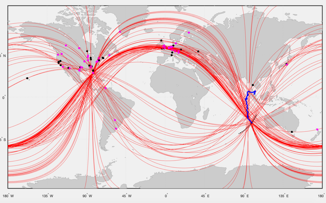
WSPRnet radio signals can reliably detect and track aircraft over long distances to the other side of the globe. Anomalies in the WSPRnet data, in either the received signal level, or received frequency, or frequency drift indicate a possible disturbance by an aircraft.
WSPRnet is a multi-static and multi-frequency system with global coverage. There are currently around 6 million distinctive links between WSPR transmitters and receivers from around the world with a propagation distance greater than 3,000 km recorded in the WSPRnet database.
The long coherent integration time of the WSPRnet receivers, the enhanced radar footprint of modern aircraft in the WSPRnet wavelength bands and the global coverage of WSPRnet propagations ensure a high level of detection and reliable tracking of aircraft.
The WSPRnet technique is, in its simplest form, statistical post processing of the meta-data from a communications link. We combine the reflection of radio waves by aircraft as used in radar, with ionospheric propagation and the WSPR protocol to detect and track aircraft over long distances.
This technique was used to track MH370 from the last confirmed radar detection on 7th March 2014 at 18:00 UTC until the end of flight on 8th March 2014 at 00:28 UTC. A total of 313 anomalies in the signal level or frequency of the WSPR signals were detected at the estimated position of MH370 at 130 different points in time.
The crash location of MH370 was at 29.128°S 99.934°E, which is outside the previous ATSB and Ocean Infinity underwater search areas.
A technical paper describing the WSPR technique for detecting and tracking aircraft over long distances can be downloaded here
@All,
Geoffrey Thomas has published the new technical paper on WSPRnet tracking over long distances.
https://www.airlineratings.com/news/mh370-update-new-report-proves-wsprnet-tracking-over-long-distance/
In an extremely significant MH370 development, a new report proves that the breakthrough technology WSPRnet can track aircraft over long distances.
Hi Richard,
Great research and a great article.
I’ve been following your search for MH370 for a while, I’ve read a news article in the NZ Daily Telegraph yesterday stating the search for the aircraft was going to start again, do you have any further news about this?
@PJB,
Welcome to the blog!
The Malaysian Minister of Transport Anthony Loke has invited Ocean Infinity to Kuala Lumpur to discuss a new underwater search for MH370.
A summary of the new proposal was presented at the recent MH370 10th anniversary event.
Research Summary
https://www.dropbox.com/scl/fi/4688b5gnwhgee698bl1r9/Research-Summary.png?rlkey=pyhdzm6ktp8i34id7melhxhtd&dl=0
Research Findings
https://www.dropbox.com/scl/fi/q52zldhur0efy2ow23xc7/Research-Findings.png?rlkey=ucxrrjbrmqbhj4gilm9wgwpgd&dl=0
Ocean Infinity Search Proposal
https://www.dropbox.com/scl/fi/9fgadj8f0yxawn1kjotj1/Ocean-Infinity-Search-Proposal.png?rlkey=q71b4kyqol52e2bmtdpeah3ml&dl=0
Unfortunately, it appears that Ocean Infinity are going back to an area between 33°S and 36°S, which has been searched twice before.
The ATSB previous search width at 33°S to 36°S was 17 nmi ether side of the 7th Arc, reducing to 10 nmi ether side of the 7th Arc North of 34.5°S. The Ocean Infinity previous search area at 33°S to 36°S was 28 nmi ether side of the 7th Arc. The new proposal at 33°S to 36°S is for a search width up to 45 nmi ether side of the 7th Arc. Ocean Infinity want to search selected areas where they admit, for the first time, that there may have been large data gaps.
I do not believe that MH370 was missed in previous searches at 33°S to 36°S.
The new search is not covering either the University of Western Australia drift analysis defined crash location or the WSPR defined crash location. If the new search is unfruitful then I hope that Ocean Infinity are willing to head further North to cover the WSPR crash location defined by a circle with a radius of 30 km centred on 29.128°S 99.934°E.
It appears that Anthony Loke and Anwar Ibrahim are appeasing the MH370 Families by doing a new search, knowing it will not be fruitful and knowing it will not expose the Malaysian government to compensation claims.
One analyst on my website said: “To me, that sounds like searching, without hoping to find anything. But let´s just imagine OI searches the 15,000 square km² without finding anything. Would they really call off the search, bringing home all the gear they have brought down to the middle of nowhere? That would mean, failing a second time without any result! For a company which is specialized, to find lost things in the ocean, that would be very(!) embarrassing. The WSPR circle is about 3,000 km². Far less than 15,000 sq km. It would make absolutely no sense, not to search the area if they do not find the wreckage elsewhere. Even if they have absolutely no belief in Richards work.”
Another analyst said on my website: “I don’t want to sound like a conspiracy theorist, but I find the delay with the new search and the decision to not include such a small area to be odd, especially when you’ve communicated with OI over a long period of time. It really does seem like this search is a token gesture to appease the relatives. The Malaysian government has a vested interest in the plane not being found. Any determination that the crash was deliberate would cost it millions in compensation.”
I fear this search will not be different in terms of outcome. It will be different in terms of a wider search width and in terms of using the latest underwater search technology.
One possibility is, that Ocean Infinity are waiting for the results of a large scale study on WSPR being run by Prof. Simon Maskell at Liverpool University, but this will take another 6 months to complete.
Liverpool University have published an insight into their research titled: “Researchers provide statistical expertise to help locate missing flight MH370.”
https://news.liverpool.ac.uk/2024/03/06/university-researchers-provide-statistical-expertise-to-help-locate-mh370/
Simon Maskell, Professor of Autonomous Systems with the University of Liverpool’s School of Electrical Engineering, Electronics and Computer Science, is providing statistical expertise and insight to the search to find Malaysia Airlines flight MH370 which disappeared on March 8, 2014, during a flight from Kuala Lumpur to Beijing.
Professor Maskell features in a new BBC documentary `Why Planes Vanish: The Hunt for MH370’ which aired at 8pm Wednesday 6th March in the UK and will air again on Channel 7 in Australia this Sunday.
During the one-hour programme, Professor Maskell discusses the work he and his team are undertaking that could provide a breakthrough in the search to locate missing flight MH370.
Professor Maskell and his team are analysing data relating to an amateur radio technology called Weak Signal Propagation Reporter (WSPR) to see if it could be used to track the final flightpath of the aircraft.
Professor Maskell said: “I strongly believe that a synergistic mix of statistics, data science and High Performance Computing (HPC) can be used to help find MH370. My team are using their expertise and know how in statistical modelling and Bayesian techniques to analyse vast quantities of WPSR data. We hope that our analysis helps in the quest to provide new evidence to support a new search and help locate MH370.”
Professor Maskell heads up the Signal Processing Research Group which specialises in Bayesian statistics, computational methodology, autonomy, machine learning, behavioural analytics and simulation.
Hi Richard. I just want to say God bless you for your hard work and dedication to solving this mystery for the families involved in this tragic incident.
We need more heroes like you.
Hi Richard Godfrey I am from Iran I am sure you will solve this puzzle. Good luck
Hi Richard,
Thanks for all your time put into this. I hope your theory is tested in the upcoming search.
On a slightly different use for WSPR – do you think it possible that a stealth aircraft may be tracked with WSPR? If not in real time then close to it using AI to process the meta data as it is generated?
Also, is WSPR as you are using it, similar to how a combat passive radar system operates?
Regards,
Andrew Berry
@Andrew Berry,
Welcome to the blog and thank you for your kind words!
It is possible to track military aircraft and possibly even stealth aircraft. The advantage of WSPR is that it is a multi-static and multi-frequency system, in other words in a military or stealth aircraft you don’t know what signals are hitting you from what direction or at what frequency.
Our WSPR technique uses the same principles as combat passive radar.
I have a few questions about MH370:
1- If the pilot intended to commit suicide, why didn’t he commit suicide in the Gulf of Thailand or the Strait of Malacca and chose a long route?
2. If the pilot intended to become a refugee in Australia, why didn’t he choose a closer route and after entering the Gulf of Thailand, didn’t he move towards northwest Australia?
3. Why is it thought that the pilot continued to guide the plane, maybe the plane was guided by the co-pilot, crew or passenger or passengers
4. Are the published images of Flight Radar 24 correct? Or is it fake? When it shows a plane passing by MH370 at high speed.
5. Is it possible that it was shot down for military reasons?
6. Is it possible to land a passenger plane on a warship?
7. Is it possible to track a off mobile in the deep ocean?
@Javad Koushkestani,
Welcome to the blog!
You ask 6 questions, here are my answers:
1. If the pilot intended to commit suicide, why didn’t he commit suicide in the Gulf of Thailand or the Strait of Malacca and chose a long route?
One possibility is that the pilot wanted to hide the evidence.
2. If the pilot intended to become a refugee in Australia, why didn’t he choose a closer route and after entering the Gulf of Thailand, didn’t he move towards northwest Australia?
I think the route chosen by the pilot shows that mainland Australia was not his destination, but he did fly close enough to Cocos Islands to have reached that airport, but chose not to and there.
3. Why is it thought that the pilot continued to guide the plane, maybe the plane was guided by the co-pilot, crew or passenger or passengers
It is theoretically possible that Capt. Zaharie Shah wanted to have a break and left the co-pilot as the pilot-in-command in the cockpit.
It is theoretically possible that a hijacker entered the cockpit in the 64.45 seconds interval defined above and told the remaining pilot or pilots to leave the cockpit.
4. Are the published images of Flight Radar 24 correct? Or is it fake? When it shows a plane passing by MH370 at high speed.
We have the entire ADS-B data from the area and no plane passed close to MH370, that would have caused a traffic collision avoidance procedure.
WSPR does not detect any commercial or military aircraft close to MH370, that would have caused a traffic collision avoidance procedure.
5. Is it possible that it was shot down for military reasons?
There is no evidence that MH370 was shot down for military reasons.
6. Is it possible to land a passenger plane on a warship?
It is not possible to land a Boeing 777 on an aircraft carrier.
7. Is it possible to track an off mobile in the deep ocean?
It is not possible for a mobile to work underwater.
Hi Richard.
I have been following you and your research for a while now, as well as everything MH370 related.
I saw the “MH370 mystery: Search for missing passenger plane must continue” from Sky News Australia, where Pilot Byron Bailey did a simulation of the flight, with a control glide at the very end, and that would position the final site of the crash at 39º 8′ S. Is that consistent with your findings from WSPRnet tracking?
@Maria Inês Marques,
Welcome to the blog!
Given the known route followed by MH370, the amount of fuel on board, the weight of the aircraft, the fuel consumption, the cost index, the performance degradation of the two Rolls Royce Trent 892B engines and the air temperature and winds encountered en-route, it is not possible to reach the point defined by Byron Bailey at 39° 8’S.
Byron Bailey’s crash location is totally inconsistent with the WSPR tracking.
People who know radio say that it is impossible for the effects of aircraft reflections from a great distance to have any noticeable effect on WSPR signals.
The WSPR database is very coarse, only shows large deviations.
This can be easily tested by using far more sensitive radio techniques.
All doubters of Mr Godfrey’s work are saying that specific data is selected to back his theory.
What is required are more tests that will show proof of the theory. Microscopic changes of frequency and signal strength would be easy to spot,
Of course then attributing any such deviations to aircraft again opens the door to selection bias.
I hope MH370 is found. It may be in the area Mr Godfrey indicates but we need real proof that his technique works. Joe Taylor the “inventor” of WSPR says aircraft detection at a distance is impossible.
@Alan,
Welcome to the blog!
People who know radio like my co-author Dr. Hannes Coetzee (call sign ZS6BZP) who has a PhD in radar and radio engineering or Dr. Robert Westphal (call sign DJ4FF) who has presented his findings on WSPR at the HamSCI Workshop agree that WSPR can detect and track aircraft.
The WSPR database is very accurate and registers differences of 1 dB in the Signal to Noise Ratio and differences of 1 Hz in the Frequency at the receiver as well as detecting drift of the order of 1 Hz/minute.
Prof. Simon Maskell at Liverpool University is testing all the aircraft airborne on 1st May 2023 using all the ADS-B data against all the WSPR data. There were an average of 21,538 aircraft airborne at any one time and 4.8 Million WSPR links on the 1st May 2023.
I sent Prof. Simon Maskell my results of tracking flight QTR901 across the Indian Ocean in the form of a Receiver Operating Curve (ROC) on 24th May 2023.
https://www.dropbox.com/scl/fi/xk0ycgjekma2k3zad1izc/Receiver-Operating-Charcteristic-ROC-171-Observations-Area-Under-the-Curve-67.png?rlkey=zia3v1qxo2ozifvv390bvomgg&dl=0
The plot of the True Positive Rate against the False Positive Rate is a standard test. It is a test of sensitivity and specificity. Sensitivity (true positive rate) refers to the probability of a positive test, conditioned on truly being positive. Specificity (true negative rate) refers to the probability of a negative test, conditioned on truly being negative.
In other words WSPR can detect an aircraft when it is there and does not detect an aircraft when it is not there.
The ROC was based on 171 observations and showed are area under the curve of 67%. This means that although WSPR is a noisy sensor, an aircraft is likely to be detected 67% of the time.
Prof. Simon Maskell responded “if the ROC curve is on the y=x line, that implies that the presence of the aircraft has no impact on the output of the algorithm and, conversely, any departure from y=x implies that the presence of an aircraft is having an impact.”
Prof. Simon Maskell said “Regarding the scepticism, I think it is hard to argue that a ROC curve that is distant from y=x is measuring pure noise.”
and
“It is more likely than not that WSPR data detected MH370,” said Maskell. “I’m on Richard’s side of the fence. If I thought it was a dead duck I wouldn’t be wasting my time.”
Other academics have taken us up on our offer of sharing all our data and processes and are reproducing our results for themselves.
Multiple intersecting anomalous WSPR links where the SNR or Frequency deviate by up to more than two standard deviations from the mean taken over a ±3 hour timeframe at an aircraft location are not selection bias, but calculated facts.
Prof. Joe Taylor who invented the WSPR protocol only stated it was not designed to detect and track aircraft, which is true. The Inmarsat satellite Burst Timing Offset and Burst Frequency Offset was not designed to detect and track aircraft. However both can provide useful information to detect and track aircraft like MH370, WSPR every 2 minutes and Inmarsat every hour. Prof. Joe Taylor has never used either to track MH370.
Hi Richard. I love your work.
Why is Ocean Infinity so slow to commence a new search? My understanding is that it has new technology and you narrowed down the search area a couple of years ago. I wouldn’t have thought its services would be in such high demand that it wasn’t available during this period.
@Graham,
Welcome to the blog!
Ocean Infinity stand by their ‘no find, no fee’ proposal for a new search for MH370 and still hope to be instructed by the Malaysian government in 2024.
Ocean Infinity could search for it and upon finding it, not disclose the location. I’m sure the Malaysian government would pay up quickly following a backlash from the passengers’ relatives and the international community.
What a brilliant idea.
Think about it.
They would have to go out and turn their AIS off once out of the shipping lanes, then search in secret, (and hopefully find it), and if they did, they would NOT tell anyone that they had found it.
They could then recover the boxes, (having already got the necessary equipment to read them themselves), and then just publish the cause of the diversion at Igari, and simply leave it at that.
Then, stand by for the legal shit show that would follow.
It would be a feast for the lawyers.
It could set new legal precedents.
@ventus45,
I am sure that Ocean Infinity would not risk its legal reputation by recovering the boxes without the permission of the Malaysian authorities.
However, there is nothing to prevent Ocean Infinity publishing pictures or a video of MH370, saying we will divulge the location, once a salvage agreement has been signed.
@All,
The BBC has announced a new documentary “Why Planes Vanish: The Hunt for MH370” to be broadcast on 6th March 2024 8 pm on BBC One and BBC iPlayer.
https://www.bbc.co.uk/mediacentre/proginfo/2024/10/why-planes-vanish
Ten years after Malaysian Airlines flight MH370 disappeared with 239 passengers and crew on board on 8 March 2014, the BBC’s award-winning This World strand looks at whether new radio technology may finally help locate the missing aircraft and asks what lessons can be learned to make aviation safer.
As new evidence emerges of MH370’s possible location through pioneering radio technology, which has never been used to locate a missing plane before, the documentary hears from scientists at the University of Liverpool who are undertaking a major new study to verify how viable the technology is, and what this could mean for locating the aircraft.
I want to start this by saying I am so in awe of your work Richard! Your dedication is so impressive! MH370 is something I constantly think about.
I have two major questions,
1. Why exactly does Ocean Infinity need Malaysia’s permission to conduct a final search? Or why won’t Ocean Infinity simply search without permission?
2. How was the plane configured when it hit the water? Some experts believe that the flaperon found on Reunion Island proves the flaps were up, yet others believe the damage show they were deployed. What is the truth? Also how did the plane enter the ocean? Did it hit nose first? Did it shatter into millions of pieces or mostly whole? And what is the evidence to back up your answer?
I personally am obsessed with the details of this case, and it bothers me when I see conflicting reports.
Thanks for taking time to read my comment and I would be so honored to learn more about it!
@kat17,
Welcome to the blog and many thanks for the kind words!
1. Ocean Infinity does not need permission to conduct a final search, but they do need an agreement with Malaysia for compensation, if they find MH370. They also need agreement with Malaysia in order to salvage any part of the wreckage.
2. The ATSB analysis of the Right Outboard Flap found in Pemba, Tanzania on 20th June 2016 confirmed that the debris item was from MH370 based on part numbers, work order numbers and a date stamp.
ATSB investigators also found an outwards fracture of the fibreglass seal pan which had started at a location adjacent to the damaged stiffeners. “The damage was most likely also caused by impact from the support track,’’ the report said. “ That damage provided further evidence of the support track position within the flap seal pan cavity, indicating that the flaps were retracted at the point of fracture and separation from the wing.’’
The flap seal pan was also fractured adjacent to the rear spar with comparable damage on the spar and on the flaperon, an adjacent moveable panel held by French experts. The investigators saw that the two damaged areas aligned, if the flaps were retracted but there was a significant offset, if they were extended.
The ATSB investigators concluded that the damage to the internal seal pan components was “consistent with contact between the support track and flap, with flap in the retracted position”. “With the flap in the retracted position, alignment of the flap and flaperon rear spar lines, along with the close proximity of the two parts, indicated a probable relationship between two areas of damage around the rear spars of the parts.
“This was consistent with contact between the two parts during the aircraft breakup sequence, indicating that the flaperon was probably aligned with the flap, at or close to the neutral (faired) position.’’
In my view, the ATSB analysis is correct and the evidence that the flaps were retracted is well documented.
The plane most likely entered the water nose first, as the WSPR data shows there was a significant forward horizontal speed and not just a significant downward vertical speed at the time of impact.
The aircraft neither remained intact, nor shattered into a million pieces.
The evidence that the aircraft did not remain intact is that we have recovered 43 item of floating debris from both the interior and exterior of the aircraft along with a large amount of personal items of cabin luggage. A seat back video housing and a cabin divider are amongst the interior items found, including items with the Malaysian Airlines decorative coating design.
The evidence that the aircraft broke into a large number of pieces is that the average weight of the 43 items found is 4.8 kg. If the rest of the aircraft broke up into pieces of 4.8 kg on average, then there would be 174,369 kg (MH370 Zero Fuel Weight) / 4.8 kg = 36,300 pieces. This number is neither one (in other words intact), nor millions (in other words shattered).
@All,
Geoffrey Thomas of airlineratings.com reports on the new BBC documentary about MH370:
https://www.airlineratings.com/news/passenger-news/outstanding-bbc-documentary-shines-a-light-on-mh370-location/
Geoffrey Thomas says the new BBC documentary “Why Planes Vanish: The Hunt for MH370” is outstanding and shines a light on the facts surrounding the loss of the Malaysian Airlines Boeing 777 and 239 souls ten years ago.
“The documentary to be shown on BBC One on March 6th at 8 pm focuses just on facts, the extensive debris found and the work of aerospace engineer Richard Godfrey and his revolutionary tracking of MH370.”
Dear Richard,
today, Malaysian Transport Minister invited Ocean Infinity to Malaysia, and offered a new “no find no fee” search if I understood correctly. I just saw a Interview with him on Youtube.
In regard of finding the plane, this is good news, I guess.
If you pinpointed the crash location within a circle of 30km, finding the plane should be a matter of weeks.
@Michael,
Ocean Infinity recently made a new proposal to the Malaysian government, which was announced today at the MH370 10th anniversary event.
The search area they plan to cover is between 33°S and 36°S, which has been searched twice before by the ATSB and by Ocean Infinity to varying search widths. The new search area is 15,000 square nmi.
The ATSB previous search width was 17 nmi ether side of the 7th Arc, reducing to 10 nmi ether side of the 7th Arc North of 34.5°S. The Ocean Infinity previous search area was 28 nmi ether side of the 7th Arc. The new proposal is for a search width up to 45 nmi ether side of the 7th Arc. Ocean Infinity want to search selected areas where they admit, for the first time, that there may have been large data gaps.
https://www.dropbox.com/scl/fi/9fgadj8f0yxawn1kjotj1/Ocean-Infinity-Search-Proposal.png?rlkey=q71b4kyqol52e2bmtdpeah3ml&dl=0
This does not include the crash location determined using the WSPR technique, which is defined by a circle with a radius of 30 km, centred on 29.128°S 99.934°E.
https://www.dropbox.com/scl/fi/irlhsoap5a2cyysjq9vvr/MH370-Crash-Location-Probability-Map-with-circle-radius-30-km.png?rlkey=saq0q191y7v29du0xok3bol18&dl=0
Are you saying that a new search may not even cover the new proposed area? If so, is it Ocean Infinity that doesn’t accept the data or the Malaysian government not wanting the correct area searched? It doesn’t seem like much of a team effort.
To me, that sounds like searching, without hoping to find anything. But let´s just imagine OI searches the 15,000 square nmi without finding anything. Would they really call off the search, bringing home all the gear they have brought down to the middle of nowhere? That would mean, failing a second time without any result! For a company which is specialized, to find lost things in the ocean, that would be very(!) embarrassing. The WSPR circle is about 3,000 km². Far less than 15.000 sq nmi. It would make absolutely no sense, not to search the area if they do not find the wreckage elsewhere. Even if they have absolutely no belief in Richards work.
@All,
1. It is good that Malaysia is willing to discuss with Ocean Infinity going back out to search 33°S to 36°S for a 3rd time.
The ATSB previous search width at 33°S to 36°S was 17 nmi ether side of the 7th Arc, reducing to 10 nmi ether side of the 7th Arc North of 34.5°S. The Ocean Infinity previous search area at 33°S to 36°S was 28 nmi ether side of the 7th Arc. The new proposal at 33°S to 36°S is for a search width up to 45 nmi ether side of the 7th Arc. Ocean Infinity want to search selected areas where they admit, for the first time, that there may have been large data gaps.
2. I do not believe that MH370 was missed in previous searches at 33°S to 36°S.
3. The new search is not covering either the UWA or WSPR crash locations.
If the new search is unfruitful then I hope that Ocean Infinity are willing to head further North to cover the WSPR crash location defined by a circle with a radius of 30 km centred on 29.128°S 99.934°E.
@All,
The goal of the Liverpool University WSPR study is to observe the ADS-B data from all the aircraft airborne on a particular day and show that WSPR can reliably detect these aircraft.
Prof. Simon Maskell says: “Given the work that Richard has conducted to date, I think it is more likely than not that we, at the University of Liverpool, conclude that WSPR has utility in the context of MH370. Assuming we do draw that conclusion, I hope the work we are doing on WSPR will enable Ocean Infinity (and others) to share the confidence we will then have in WSPR’s utility in the context of MH370. We are intending to reach a conclusion and, assuming we conclude that WSPR has utility, then define a refined (relative to what DST Group proposed) search area in a timeline that could influence a future search by Ocean Infinity.”
The goal of my work is to observe the WSPR anomalies from the MH370 estimated position from a known start point at 18:00 UTC from the civilian radar data.
This work is completed. We have observed and published 313 anomalies in 95 locations along a MH370 flight path to a definitive crash location within a circle with a 30 km radius centred on 29.128°S 99.934°E.
The facts are:
1. Ocean Infinity include Liverpool University and Richard Godfrey in their slide on the Research Summary.
https://www.dropbox.com/scl/fi/4688b5gnwhgee698bl1r9/Research-Summary.png?rlkey=pyhdzm6ktp8i34id7melhxhtd&dl=0
2. Ocean Infinity include Liverpool University drift study but not their WSPR study in their slide on the Research Findings.
Ocean Infinity conclude most of the studies post 2018 have confirmed previous analyses and mention two studies from the Independent Group.
Ocean Infinity note that “A single reliable position for the aircraft in the final few hours of the flight derived from Richard Godfrey’s WSPRnet work would make the potential search area much smaller.”
https://www.dropbox.com/scl/fi/q52zldhur0efy2ow23xc7/Research-Findings.png?rlkey=ucxrrjbrmqbhj4gilm9wgwpgd&dl=0
3. Ocean Infinity completely ignore the UWA (28°S to 33°S) and WSPR (29.128°S 99.934°E) findings in their Search Proposal of 33°S to 36°S.
https://www.dropbox.com/scl/fi/9fgadj8f0yxawn1kjotj1/Ocean-Infinity-Search-Proposal.png?rlkey=q71b4kyqol52e2bmtdpeah3ml&dl=0
Why do you think OI aren’t prioritising your area which you’ve identified by WSPR?
It seems like such a no brainer to search this small area with new data first, I can’t understand why they aren’t planning to do that. I’ve read your paper and it’s very convincing! It’s interesting how it matches the idea of a pilot avoiding traffic.
Any ideas what OIs motivations were for their proposed area?
@Jenny Smith,
Welcome to the blog!
You ask why OI aren’t prioritising the area defined by the WSPR technique?
I wrote to Oliver Plunkett the CEO of Ocean Infinity, asking him the same question.
OI are possibly waiting for the publication of the large scale validation study results by Liverpool University using WSPR to detect all the aircraft in the air on a particular day last year and then applying WSPR to the DSTG model of the MH370 flight path.
OI might simply be trying to walk a political tightrope between what Malaysia might agree with and what OI might be willing to fund in a no find, no fee agreement.
Both OI and Malaysia have promised that they will go back out and search. They did not promise to search every possible analyst’s favoured location. OI are doing the safe thing by going back to the area between 33°S and 36°S for the 3rd time. The ATSB, DSTG, CSIRO and Ocean Infinity all agree on this area. Only the UWA and WSPR point to a different area. UWA says between 28°S and 33°S, WSPR says 29°S.
People are sceptical of new technology until it becomes accepted into the mainstream and that can take some time.
If OI do not find MH370, then I am talking to two other organisations, who are willing and able to conduct another underwater search.
Richard, I know you’ve done a lot of work into locating MH370 over recent years and it seems like the only credible new offering.
I don’t want to sound like a conspiracy theorist, but I find the delay with the new search and the decision to not include such a small area to be odd, especially when you’ve communicated with OI over a long period of time.
It really does seem like this search is a token gesture to appease the relatives. The Malaysian government has a vested interest in the plane not being found. Any determination that the crash was deliberate would cost it millions in compensation.
@Graham,
I find it odd too!
Thanks so much for the reply, and the detailed explanation.
I’m not a physicist but I think psychologically speaking it interests me that we know the plane was flown in a pattern which would evade detection around Panang area, so it seems logical to me that that would be repeated later in the flight plus the circling at the end matching a proposed review of possibly shipping vessels.
I’m really pleased to hear you are in discussions to ensure that in this tenth year after the tragedy that either OI or another company will hopefully search the area you’ve identified.
Good afternoon Richard,
I think your work is incredible and so important for someone to think ‘beyond the usual’ in instances like this.
I can understand to some degree the caution in acceptance of your approach, however isn’t the evidence provided so far enough to instigate a search? There is little else to go on and as time passes and we fast approach 10 years of the unknown, it feels inevitable that no one else is going to have any breakthroughs that are as viable and robust as yours.
Will the large scale validation study that is being carried out at Liverpool University tell us anything that we don’t already know from your work?
@Helen Smith,
Welcome to the blog and many thanks for the kind words!
The large scale validation study by Liverpool University is very important because it is independent, academic and wide ranging.
Any new scientific theory requires independent validation by other scientists, who have an academic standing. The scale is important because it shows the general applicability of the theory and not just the specific applicability to the MH370 case.
If you dropped 16/32 floating items in a grid across the suspected crash location and GPS tracked them, and they turned up on beaches months later would that help narrow the search area.
@Robert Gibson,
Welcome to the blog!
A nice idea and that is what Oceanographers try and simulate with their models of the Indian Ocean. They ‘release’ 10,000 particles at different locations across a grid around the suspected crash site and watch where the particles end up.
The problem is the Indian Ocean is a turbulent and unpredictable area with currents, winds and eddies.
A good example of such a drift analysis was performed by Prof. Charitha Pattiaratchi, an Oceanographer at the University of Western Australia:
Here is a link to a recent article in The Conversation written by Prof. Charitha Pattiaratchi:
https://theconversation.com/mh370-disappearance-10-years-on-can-we-still-find-it-224954
@All,
A great article in The Conversation by Prof. Charitha Pattiaratchi titled “MH370 disappearance 10 years on: can we still find it?”:
https://theconversation.com/mh370-disappearance-10-years-on-can-we-still-find-it-224954
@All,
A great interview with Geoffrey Thomas about MH370 on ABC The World:
https://www.youtube.com/watch?v=Jpx_SDV_FWA
@All,
A feature article in The Times in the UK today:
https://www.dropbox.com/scl/fi/n5nmj54e0ujvmkcw23k15/MH370-Times-06MAR2024.pdf?rlkey=93bczmzkrm9onxw7v1q0pvk9k&dl=0
“I think,” said Richard Godfrey, “it will only take one more search and we will find it.”
“The world is crisscrossed with low-power radio pulses, transmitted by ham operators, in a protocol known as Weak Signal Propagation Reporter (WSPR). When something flies through those pulses, it creates a disturbance. Godfrey thinks that we can track that disturbance, and is working with Simon Maskell, an academic at Liverpool University, to narrow down the search area.”
“It is more likely than not that WSPR data detected MH370,” said Maskell. “I’m on Richard’s side of the fence. If I thought it was a dead duck I wouldn’t be wasting my time.”
@All,
Liverpool University have published an insight into their research titled: “Researchers provide statistical expertise to help locate missing flight MH370.”
https://news.liverpool.ac.uk/2024/03/06/university-researchers-provide-statistical-expertise-to-help-locate-mh370/
Simon Maskell, Professor of Autonomous Systems with the University of Liverpool’s School of Electrical Engineering, Electronics and Computer Science, is providing statistical expertise and insight to the search to find Malaysia Airlines flight MH370 which disappeared on March 8, 2014, during a flight from Kuala Lumpur to Beijing.
Professor Maskell features in a new BBC documentary `Why Planes Vanish: The Hunt for MH370’ which airs at 8pm tonight (Wednesday 6 March) .
During the one-hour programme, Professor Maskell discusses the work he and his team are undertaking that could provide a breakthrough in the search to locate missing flight MH370.
Professor Maskell and his team are analysing data relating to an amateur radio technology called Weak Signal Propagation Reporter (WSPR) to see if it could be used to track the final flightpath of the aircraft.
Professor Maskell said: “I strongly believe that a synergistic mix of statistics, data science and High Performance Computing (HPC) can be used to help find MH370. My team are using their expertise and know how in statistical modelling and Bayesian techniques to analyse vast quantities of WPSR data. We hope that our analysis helps in the quest to provide new evidence to support a new search and help locate MH370.”
Professor Maskell heads up the Signal Processing Research Group which specialises in Bayesian statistics, computational methodology, autonomy, machine learning, behavioural analytics and simulation.
@All,
The BBC documentary “Why planes vanish: The hunt for MH370” was broadcast in the UK yesterday evening. You can watch it on the BBC iPlayer, if you are in the UK.
It will also be broadcast in Australia on Channel 7 this coming Sunday.
“Why planes vanish: The hunt for MH370” is the best documentary on MH370 to have been produced so far and is a well balanced portrayal of the events surrounding MH370.
The documentary includes some of the MH370 families, Grace Subathirai Nathan, Nathan Velayudhan and Jacquita Gonzales, some of the official investigators Fuad Sharuji, Pete Foley, David Griffin, some of the independent analysts Jean-Luc Marchand, Capt. Patrick Blelly, Capt. Paul Cullen, Blaine Gibson, Prof. Simon Maskell and myself.
Dear Richard,
I enjoyed the Liverpool University news story. Do you have any idea when Prof Maskell’s first research paper on WSPR will be published?
Thanks so much for all your work. I will definitely be watching the UK documentary when I have time!
Jenny
I watched the BBC documentary tonight and ended up here reading all the comments on the various posts, and looking through your detailed papers. Outstanding work Richard, absolutely amazing.
The one thing that bothers me is the intent of the pilot, and why he did these things. None of it really makes any sense. If it’s suicide why wait until you run out of fuel? Your analysis indicates he was in control changing directions and speed. To what end?!
The holding pattern is fascinating, as is the heading towards the airport in Australia for a short period.
Why did he seemingly go to such lengths to conceal the location of the aircraft?
If he was being made to do what he did – surely he’d have found some way in all that time to do something like turn the transponders back on for a short period?
There just doesn’t seem to be a plausible motive for the actions he took.
@Gary Sargent,
In my view the pilot not only wanted to commit murder-suicide, but also wanted to hide the evidence in a remote part of the southern Indian Ocean.
The pilot did not simply fly a straight line for 6 hours into the Southern Indian Ocean until fuel exhaustion, because that makes it rather obvious where MH370 would end up. We have searched those obvious locations and found nothing.
One of the biggest problems in analysing the flight path of MH370, has been the straight line thinking. When an aircraft flies from its departure point to a destination, it follows a straight line. More precisely it follows a great circle path, which is the shortest distance around the globe between A and B. Along a great circle path the track of the aircraft is very slightly changing all the time, but to all appearances this is a straight line.
When an aircraft is hijacked it does not follow a straight line. No one is supposed to know where the destination is. The aircraft does not follow a direct route from A to B, because you are not meant to find out the location of B.
All MH370 analysts so far have assumed following the final turn towards the Indian Ocean in the Malacca Straits, that MH370 continued for 6 hours in a straight line.
This is a huge assumption, which is only justified if the aircraft was on auto-pilot with no intervention from an active pilot.
More than that, it is possible to draw a straight line, from a carefully chosen starting point at a carefully chosen time, that matches all the hourly Inmarsat satellite data.
The so called UGIB paper that I published 4 years ago together with Bobby Ulich, Victor Iannello and Andrew Banks on 7th March 2020 is a prime example of straight line thinking.
https://www.dropbox.com/scl/fi/ytj26z9d5fohg8j77u2jh/MH370-SkyVector-Chart-4.png?rlkey=sakqp9pcsue6pnmvmr4x9ml89&dl=0
You will still find the crash location marked on the map as the “IG Hotspot” at 34.2342°S 93.7875°E on the latest Ocean Infinity proposal.
https://www.dropbox.com/scl/fi/9fgadj8f0yxawn1kjotj1/Ocean-Infinity-Search-Proposal.png?rlkey=q71b4kyqol52e2bmtdpeah3ml&dl=0
But in retrospect, the data in the UGIB paper was manipulated by Bobby Ulich to match an unrealistic and tortuous Final Major Turn (FMT) route between 18:23 UTC and 19:41 UTC.
https://www.dropbox.com/scl/fi/znuaq8uqqxu4j9e5uudu0/Fig.-22-FMT-2b.-Bobby-Overall-Route-Turns-and-Key-Points-Zoom.png?rlkey=60hrcmfqeo4v341u6f98te5di&dl=0
Only the WSPR based analysis has shown there was an active pilot until the end and there were a number of turns, climbs and changes of speed.
https://www.dropbox.com/scl/fi/tntc327zc4ps4xl2apoji/MH370-Flight-Path-Analysis-Map.png?rlkey=4ixz2oz5lnkzqwrw08heha8fo&dl=0
The active pilot theory has now also been backed up by the analysis of Capt. Patrick Blelly and Jean-Luc Marchand.
@Richard Godfrey,
Definitely agree the evidence suggests the pilot was in control for the whole duration, not auto pilot.
What doesn’t add up though is…
1) The simulator practice flights which suggest very premeditated actions.
2) Friends and family say he was of good character and not depressed etc. Obviously they could be mistaken and he hid it. No other obvious reasons for his actions.
3) Why care about hiding the plane?
4) Why plan to kill all those innocent people as part of your long thought out plan?
5) Why the holding pattern? Then a heading to Australia? Maybe he changed his mind, then back again?
6) If the intention was to kill people, why not crash into a building?
For me the intentions of the pilot just don’t seem to add up unless he is completely crazy, which you’d assume he isn’t.
Also it would be interesting to see if the pilot had tried anything before, like turning off his transponder at the first waypoint. Is it easy to look through his previous flights on the same route for any anomalies?
Hi Richard,
What are your thoughts about the newly released information from scientists that researched the barnacles attached to the flap (my link highlights the specific text that I am referencing). My understanding is that a number of different studies have been conducted and that, based on the size of the barnacles, the debris couldn’t have been in the water for more than four months.
https://nymag.com/intelligencer/article/mh370-search-debris-barnacles.html#:~:text=If%20one%20assumes%20the%20flaperon%E2%80%99s%20barnacles%20grew%20at%20an%20approximately%20similar%20rate%2C%20then%20the%20size%20of%20the%20flaperon%E2%80%99s%20barnacles%20suggest%20that%20it%20floated%20in%20the%20Indian%20Ocean%20for%20no%20more%20than%20about%20four%20months%2C%20not%20the%2016%20months%20that%20elapsed%20between%20the%20crash%20and%20the%20flaperon%E2%80%99s%20discovery
I want to mention that I am in no way suggesting a conspiracy, or anything along those lines. MH370 is a mystery, and as such, new information (research, evidence, data, etc) tends to raise more questions than answers. Still, I find it interesting, and I’m curious to hear your thoughts.
@Brandon Scivolette,
I have read the original research, rather than an article by Jeff Wise, a well known MH370 conspiracy theorist, infamous for his Netflix documentary disaster.
In my view the original research is promising, but is a work in progress.
I have commented before on this website on this study.
A new study has been published titled “A Stable Isotope Sclerochronology-Based Forensic Method for Reconstructing Debris Drift Paths With Application to the MH370 Crash” by Nasser Al-Qattan, Gregory S. Herbert, Howard J. Spero, Sean McCarthy, Ryan McGeady, Ran Tao, Anne-Marie Power.
https://agupubs.onlinelibrary.wiley.com/doi/10.1029/2023AV000915?fbclid=IwAR3dGkrINfCajAw62H7thuorrF_Ia9j4EJoUpgtlb_zpghBcaFpmeLiq5hk
I am not a marine biologist or oceanographer. As a physicist, I can only make general observations.
As the authors state in their study: “A severe limitation of this approach is that individual Sea Surface Temperatures do not have unique spatial solutions, especially on the scale of ocean basins over time.”
I would also point out the statement by oceanographers Rosemary Morrow and Pierre-Yves Le Traon: “The ocean, like the atmosphere, is a fundamentally turbulent system.”
1. The study does not give a crash location for MH370, but rather presents a method for determining the MH370 crash location.
2. The study focuses on one item of debris, the Flaperon found on Reunion. There are 43 items of possible MH370 floating debris which have been reported to the authorities from around the Indian Ocean. A number of other items also had barnacles attached when found.
3. The range of duration between 8th March 2014 and the time of reporting the various finds possibly from MH370 is from 508 days to 1,626 days. The study focuses on one specimen A2-G1 from the Flaperon with an estimated age of 154 days. This only covers 30% of the 508 days the Flaperon drifted.
4. David Griffin, the oceanographer appointed by the ATSB to investigate the MH370 drift analysis showed the importance of considering both Stoke’s drift and windage, both of which were ignored in this study.
5. Charitha Pattiaratchi, the oceanographer from the University of Western Australia, who investigated the MH370 drift analysis, questioned the utility of this study in being able to determine precisely the crash location of MH370.
“This same method could be applied to the largest, oldest barnacles collected from the same debris to provide important information about the debris drift origin and location of the missing plane.”
“Only partial drift reconstructions are possible until the largest, oldest barnacles are released for study by the French government.”
Barnacles are a great help to find the arrival time of a debris item. There are 4 items MH370 floating debris, which have been found with barnacles. Many barnacles were attached to the Flaperon when reported on Reunion. The Flaperon was taken to France and examined in detail by various authorities. Dr. Joseph Poupin, a Marine Biologist and an expert in crustaceans, took samples of the barnacles from 5 locations on the Flaperon on 9th August 2015, 11 days after the Flaperon was reported. A picture of the Flaperon barnacles is linked below:
https://www.dropbox.com/scl/fi/faytgvkq28j7qtmvpf0gh/Barnacles-Reunion-Flaperon.jpeg?rlkey=thba46cwccyrki93xh7ik2vu5&dl=0
As the barnacles had been out of the water for at least 11 days, they had lost their ability to generate the adhesive chemical they normally produce to maintain their attachment to their host and were easily falling or breaking off the Flaperon. It was decided to collect all the remaining barnacles. The DGA note in their report that the remaining barnacles, after sampling, had a total weight of 468.3 g. The barnacles were of the species Lepas Anatifera.
Professor Patrick De Deckker of the Australian National University was asked to perform an analysis of one of the barnacles from the Flaperon. He was given a barnacle 2.5 cm in length and used a laser to examine the make up of the shell by drilling tiny holes 20 microns in diameter. De Deckker determined the ratio of magnesium to calcium, which give clues to the temperature of the water in which the barnacle is growing. De Deckker cautions that the results are not conclusive, but it appears that the on-start of growth of the barnacles occurred in warmer waters, then the most extensive period of growth then took place in cooler water temperatures, and finally the more recent growth happened in the tropical waters around La Reunion. The picture below is courtesy of the Australian National University:
https://www.dropbox.com/scl/fi/1kx5yqltja37spe7l5e0x/MH370-Barnacle-Analysis.jpg?rlkey=br37pu1w8f0593v0z6rry32d9&dl=0
A study of barnacles (predominantly Lepas Anatifera), gathering on and below the water line of an oil rig structure towed on its side by ship from Japan to New Zealand mostly through tropical waters, showed that there were colonies of barnacles with an average size of 248 lepas per m2 and with an average weight of 0.29 g. Barnacles were found on both submerged parts of the oil rig as well as surfaces below the splash line.
In the sea trials performed by David Griffin, with an authentic Flaperon cut down to the size of the damaged Flaperon from MH370, it was found that the Flaperon was pitching over every few minutes during the sea trials and did not simply drift along with its tail raised to the wind. This would keep the barnacles below the water for sufficient time for them to feed and survive.
The full surface area of the Flaperon is 7.9812 m2 and at 248 lepas per m2, you would expect to find a colony of almost 2,000 barnacles upon arrival. The total weight of barnacles found by the DGA was 468.3 g and if the average weight of a barnacle was 0.29 g, then you would expect a colony of around 1,600 barnacles. Given that several batches of between 30 and 50 samples were taken before weighing of barnacles and given that some barnacles may have been lost between beaching in Reunion and arriving in France, then the two calculation methods generally align.
Dr. Poupin compared photographs and videos taken in Reunion with the Flaperon he examined in France and confirmed in his report that there was no substantial loss of barnacles in the 11 day interval. Although the number of barnacles found is aligned to the number of barnacles expected, Dr. Poupin concluded that the Flaperon did not pitch over and remained submerged with only the flat underside facing upwards. Dr, Poupin identified 4 generations of colonies of barnacles on the Flaperon and concluded that the debris item had been in the water for 476 days. The Flaperon was found on Reunion 508 days after the crash of MH370.
From laboratory experience it takes barnacles 4 days to die, when out of sea water and unable to feed. From the observations of Dr. Poupin we know it takes 11 days for barnacles to start detaching from their host. From expert estimates, it takes 4 to 24 days for scavengers to clean a debris item. From the debris item “Roy” we know when it was found for the second time after 89 days, it was clean of barnacles.
The new study claims much more precise methods of tracking the MH370 Flaperon by analysing the barnacles attached to the Flaperon using the sea temperature experienced at each stage of development. The study cautions the possible precision achieved as “A severe limitation of this approach is that individual Sea Surface Temperatures do not have unique spatial solutions, especially on the scale of ocean basins over time.”
However I am sure that Alain Gaudino, the judge in charge of the MH370 case in France or Dr. Joseph Poupin the marine biologist, who examined the barnacles on the MH370 Flaperon, can spare a few of the older barnacles for researchers like Nasser Al-Qattan from the University of Kuwait and Gregory Herbert from the University of South Florida.
I’ve been looking at “How does WSPR detect Aircraft over long Distances? Technical Paper” and have a few questions.
First, there seems to be an assumption that the aircraft scattering will predominantly be at 180 degrees meaning that the transmitting station (Tx), Receiving station (Rx) and aircraft are all on the same Great Circle. I don’t see a mechanism for this, and amateur radio enthusiasts find that aircraft scatter can be at many angles.
Second, the anomaly detection criteria seem to be remarkably low. You compare the standard deviation (SD) of the mean signal level and get detections at differences of 1.5 SDs, in some cases less than one. Is that good enough for a detection? 44% of the measurements will be within this range.
Are you using your knowledge of the aircraft’s position, in this case THY161, as a guide to what Tx and Rx stations to use and as a guide to where to look in the data? If so I don’t see how you can use this as an indication that the anomaly is an aircraft detection or noise.
Given this, even assuming that reflections are only at 180 deg I don’t see how you can work from what seems to be an unreliable detection to determine an unknown aircraft position. You don’t know what Tx-Rx pairs to use and you don’t know where to look. It would be easy to inadvertently track noise.
I hope I’m wrong, that my concerns are unfounded. I’d like to know where.
Chris
@Chris,
Welcome to the blog!
Obviously scatter is at many angles, but also reflected back at 180°.
The alignment of transmitter, aircraft and receiver along a great circle is not an assumption, it is a measured fact calculated using a Vincenty geodesic iterative method.. Please see the results table in the paper.
As explained in the paper, we are using the ADS-B data from the aircraft to determine the position of the aircraft during the 110.6 seconds of each WSPR transmission.
You do not appear to be taking into account the integration in the WSPR receiver over the transmission time of 110.6 seconds.
Out of 194 WSPR signals analysed at 13 points of time during the flight, there were 44 anomalies detected, comprising 21 frequency anomalies between -225% SD and +190% SD, 19 signal SNR anomalies between -166% SD and +163% SD and 4 drift anomalies. Please see the results table.
We know exactly where to look from the ADS-B data and we know exactly which WSPR links cross the aircraft flight path during each WSPR transmission.
Our Receiver Operating Characteristic (ROC) curve is consistent with a threshold of 0.75 SD achieving a false alarm rate of approximately 45%, but it also articulates that the probability of detecting the aircraft is higher. We have always made it clear in our papers that WSPR is a noisy sensor, but the ROC curves show it has utility in detecting and tracking aircraft.
https://www.dropbox.com/scl/fi/sjuqnrzpsp0yc84nu8psa/ROC-143-Observations-with-confidence-intervals.png?rlkey=yh8pzttlkx8dknkerqeqk5h3m&dl=0
Dear Richard,
Could you kindly give me your email address?
With thanks,
Kevin
@Kevin Foster,
Welcome to the blog!
My email address is: richard@mh370search.com
@Gary Sargent,
You ask 6 questions, here are my answers:
1) The simulator practice flights which suggest very premeditated actions.
I agree, this hijacking and murder-suicide was very carefully planned and very carefully executed.
2) Friends and family say he was of good character and not depressed etc. Obviously they could be mistaken and he hid it. No other obvious reasons for his actions.
Andreas Lubitz, the co-pilot on the German Wings flight, that was deliberately flown by him into the mountains in the Alps, was on medication for depression and successfully hid that fact from colleagues and friends for quite a long time.
3) Why care about hiding the plane?
So there was no conclusive evidence of a murder-suicide and investigators would suspect a hijacking or aircraft malfunction instead.
4) Why plan to kill all those innocent people as part of your long thought out plan?
A global academic study of 1,725 mass murders showed the following findings:
Psychosis or disorganisation related to mental illness were infrequently motivational factors (166; 9.6%), and were significantly more associated with mass murder committed using methods other than firearms.
The vast majority (998, 57.86%) of incidents were impulsive and emotionally-driven, following adverse life circumstances.
Most mass murderers prompted by emotional upset were found to be driven by despair or extreme sadness over life events (161, 16.13% within the category); romantic rejection or loss, or severe jealousy (204, 20.44% within the category); some specific non-romantic grudge (212, 21.24% within the category); or explosive, overwhelming rage following a dispute (266, 26.65% within the category).
5) Why the holding pattern? Then a heading to Australia? Maybe he changed his mind, then back again?
As previously reported, the holding pattern was an artefact of an earlier version of the software used in the analysis.
The change of heading toward Australia or the Cocos Islands (a remote territory of Australia in the Indian Ocean) took place several times both when within fuel range and later when no longer within fuel range.
https://www.dropbox.com/scl/fi/tntc327zc4ps4xl2apoji/MH370-Flight-Path-Analysis-Map.png?rlkey=4ixz2oz5lnkzqwrw08heha8fo&dl=0
6) If the intention was to kill people, why not crash into a building?
So that there was no possibility of any conclusive evidence of a murder-suicide being found and investigators would suspect another cause instead. The black boxes are designed to survive an impact and are much easier to find after a crash on land, than at the bottom of the ocean in water which is over 3,000 m deep.
I agree with Richard. We do not know exactly the motive, and we do not have to. But if we had to guess, the pilot was probably upset about Anwar being put in jail for sodomy, upset at Razak, and planned a protest downing a plane full of foreigners which would make Razak look bad and possibly force him out of power. The sim cases are flight to Saudi Arabia, it looks like, think about it how sensitive that is for the world. Razak handled it adeptly as far as staying in power by, among other things, avoiding blaming Anwar supporter(s) for doing this deed, which is probably indeed what happened though. Untouchable truth in Malaysia, and perhaps some things we do not understand cause nobody is fessing up.
And I am not the least bit interested in blaming the pilot, just find the plane, but to find the plane, I believe we have to realize the pilot hid it. I think the data is semi-easy to see the answer if we accept it was intentional to the end, but that is politically incorrect.
Hi Richard,
The BBC show was aired on Australia just under an hour ago. I’m surprised at how quick it came to our screens! I have not come across your work before, and was very surprised by how the outcome was aligning to my thoughts.
I will explain more. I believe that part of solving the location of the crash site comes down to Motive.
Part of this whole problem is that people are trying to explain it with one consistent story. Why?
I will raise the question – If you split the MH370 flight path into two episodes, that divided just outside of when the plane came out of range of Malaysian military radar, then how would your explanations vary?
If you look at the first “episode”, it is almost a classic hijack, 911 style. A complete U-turn, obviously strong physical effect (as shown in the BBC doco), showing an experienced pilot in control, followed by a straight line flightpath, with a controlled turn at the next weighpoint. This is not an amateur in control, not someone who has learn’t to fly on a sim. We know there were only 2 such people with these skills on the plane.
So, lets move to the second episode. It becomes erratic. Still the experienced pilot in control, but something has changed. We are no longer on a straight line flight path. In episode 1, we have someone with a clear objective, a clear mission, in control. Something has changed in episode 2.
Why erratic? Something has affected the stability of the plane. The effect? The mission can no longer be completed. UA93 faced a similar situation – the hijackers realised that their time was up, they became Kamikaze, there was no turning back.
Once the MH370 Pilot comes to this realisation of failure, what were his options? Return back to KUL, disgraced, his family disgraced, his country disgraced because of the hijacking he had initiated? Or take the plane where it could never be found, the disgrace never exposed?
Lets talk more about Motive. On leaving KL, the plane took on an extra 3000kg fuel. Why? Was the mission already planned? As you have mentioned, there seems to be elements within Malaysia that do not want this story to come out.
So what’s my point? I want to throw a curved ball at you, something to challenge your assumptions.
Up until now, the assumption has been that the plane just kept flying until it ran out of fuel. The flying time estimates have been measured based on expected consumption rates and amount of fuel loaded at KUL.
BUT, if the aircraft had been severely damaged at the point just as it gets out of standard radar range, and has more drag / is less aerodynamic, how would this affect your estimates of where it came down? Could this damage help explain the erratic directions that the plane was flying?
Personally, I think you have done a brilliant job, but at the same time, if funding for a search does become available, I am sure that the Malaysian Government will only approve it if they know that it will cover a location where they know the plane will not be.
Regards,
Steve
@Steve,
Welcome to the blog!
The 3,000 kg fuel is company policy to allow for 30 minutes extra flying time as a contingency. It was noted on the official flight plan as “Comp Fuel”.
You say, we know there were only 2 such people with these skills on the plane. How do you know that there was not a hijacker on board, who was a trained Boeing 777 pilot?
If the aircraft was severely damaged, then the pilot would attempt an emergency landing at the nearest airport. A severely damaged aircraft, irrespective whether that damage was mechanical, electrical or fire, does not continue to fly for 7 hours following an emergency diversion. The rule of thumb is you have about 20 minutes to make an emergency landing. No such emergency landing was attempted at Kota Bharu, Penang, Phuket, Banda Aceh or other airports in the vicinity of the MH370 flight path.
The changes of direction were to make the flight path difficult for ATC to ascertain the pilot’s intentions. The pilot may have been making use of the TCAS system to see if there were any other aircraft in the vicinity. As soon as you switch on the TCAS system, you give away your position to any other aircraft within range. If MH370 was detected by another aircraft, then the pilot wanted to ensure that the direction did not give away his intended destination.
If you fly in a straight line for 6 hours over the Indian Ocean until fuel exhaustion, then it is easy to calculate where you will end up. We have searched this area and did not find MH370.
Hi Richard,
Thanks for clarifying those points, and providing an alternative explanation for the erratic flight path.
In regard to finding a third possible pilot for that plane, I expect (and yes, it is an assumption) that the Chinese passengers would not qualify. Means to get trained, and motive would be an issue. The Chinese Government could perhaps finance such training (they’d have the means), but why? The plane is already on its way to China.
We are left with the rest. I’ve read another site that has done extensive research into the backgrounds of all these passengers. Yes, some have murky backgrounds and business dealings, but the Russians, Ukrainian, Americans and Australians seem to be in the clear.
I’ll see what I can find on the motive and means for other passengers. Red flags are clearly on the passengers with stolen passports. They do not appear to be qualified 777 pilots, but as to their role, I pass no judgement.
From an evidence viewpoint, what is missing from this are phone records from the MA pilots on the days / weeks before the flight, the money trail, and records of the cargo swaps.
All in the hands of the Malaysian investigators, and nothing openly disclosed. If it wasn’t investigated at the time, I expect it is too late now.
You are so on the mark with your research.
Sorry, yes, I forgot one other option – a stowaway 777 pilot, not on the passenger list.
Not as likely as the MA pilots, but still another option that could be considered, but very difficult to prove either way.
https://www.securityinfowatch.com/critical-infrastructure/news/10550974/aircraft-stowaway-cases-show-security-loopholes
Hi Richard,
Thanks for explaining many scientific aspects in layman’s terms.
Sincere apologies for my ignorance with this question – is it possible that parts of the aircraft were submerged in the water for some time, and then broke away to resurface? Or, is just under 5kgs for the average object too heavy?
Also, the surface search of the Indian Ocean was not focused in the correct area?
Thanks again.
@Bec,
Welcome to the blog!
If a part that breaks away has enough air trapped inside it, then it will float to the surface.
The AMSA surface search covered 4.7 Million km², but was only started on 17th March 2014, which is 9 days after MH370 crashed.
The surface search lasted 42 days and ended on 28th April 2014, which is 52 days after MH370 crashed. In 52 days floating debris would have dispersed over a possible area of 3.5 Million km².
https://www.dropbox.com/scl/fi/tnmflb2udys1r2nc4kc76/AMSA-Search-Area-Cumulative.png?rlkey=gwx29iewrew6p2b8tuipfadya&dl=0
https://www.dropbox.com/scl/fi/y7xkdz7f2kyxxos6yk8e9/AMSA-SLDMB-Presentation.pdf?rlkey=l6fo2g8m9tcvhw32jqumzu0rw&dl=0
@All,
An interview on BBC News with Jonathan Head SE Asia Correspondent and Prof. Simon Maskell of Liverpool University.
https://www.youtube.com/watch?v=9SEMSQDO-pg
Simon explains their work to validate WSPR, which will take around 6 months to complete. He hopes to be able to pinpoint a much smaller crash location for MH370 and thereby significantly increase the chances of finding the aircraft.
@All,
I have two major problems with the new Ocean Infinity proposal.
1. The Ocean Infinity proposal has a major discrepancy.
Victor Iannello states on his website: “The search area, which may be refined later, extends along the 7th arc from about 33°S to 36°S, and out to about 45 NM (83 km) on either side of the arc.”
Ocean Infinity state that the 2024 proposed search area is ≈ 15,000 km².
The two new search areas marked on the map from OI are each 15,114 km².
So either Victor Iannello has got it wrong and the OI map is incorrect and they are planning to search ≈ 15,000 km², or Victor Iannello and the map are correct and OI got their calculation wrong and are really planning to search ≈ 30,000 km².
https://www.dropbox.com/scl/fi/9fgadj8f0yxawn1kjotj1/Ocean-Infinity-Search-Proposal.png?rlkey=q71b4kyqol52e2bmtdpeah3ml&dl=0
2. The Ocean Infinity proposal is driven by Capt. Patrick Blelly and Jean-Luc Marchand’s paper titled “Analysis of the trajectory of Flight MH370”.
The search area proposed extends southwards to 35.875°S 93.039°E, which is just included within the OI proposal with a cut off at 36°S.
The search area proposed, including contingency, extends out to 35.8741°S 89.7296°E, which is 37 nmi from the 7th Arc. OI has decided to search up to ≈ 45 km.
However, the Blelly-Marchand analysis is flawed for the following reasons:
2.1 RAT deployment.
We are agreed that there was an active pilot until the end of flight.
We are agreed that both the military radar data and the civilian radar data are subject to inherent measurement uncertainties both in time and slant range.
Yet they conclude that the turn back following diversion indicates the pilot was flying manually, based on the military radar.
They further hypothesise that the RAT was deployed forcing manual flying in a degraded control mode with degraded flight information.
Once deployed the RAT cannot be retracted and will continue to add drag to the aircraft and increase fuel consumption.
Later they revert to auto pilot flight and we are agreed that the long leg into the southern Indian Ocean was using autopilot.
2.2 Straight Line Flight from 18:40 UTC to 00:11 UTC.
They hypothesise a “quasi-straight-line path to the south” from 18:40 UTC to 00:11 UTC, firstly at 188°M then at 178°T.
This is based on the Inmarsat satellite BTO and BFO data alignment as shown in their Table 17.
The big question is what happened in between the approximately hourly gaps in the Inmarsat satellite data?
They make a big assumption, that the pilot continued in a straight line flight for each of the approximately hourly legs in between each satellite data point.
2.3 Controlled Ditching.
They conclude that there was a “final controlled ditching producing little debris” and a “soft ditching producing only a few small pieces of debris”.
The 43 possible or confirmed MH370 floating debris items recovered show however a complete break up of the aircraft with parts from both the exterior and interior of the aircraft. There were items externally from the nose, wings, engines and tail, as well as items internally from cabin dividers, flooring, seat back video trim, clothing, shoes and hand luggage.
The fact that only 43 items have been found may also be due to the fact that there was no official search along the likely shores of the Indian Ocean.
To state there were “only a few small pieces” is incorrect.
There were large items like the Right Flaperon Structure weighing 40 kg and measuring 2.3 m x 1.3 or the Right Outboard Flap weighing 39 kg and measuring 2.4 m x 1.2 m.
The average weight of the 33 items analysed was 4.9 kg. If the rest of the aircraft broke up into pieces of 4.9 kg on average, then there would be 174,369 kg (ZFW) / 4.9 = 35,600 pieces.
2.4 Fuel Range and Endurance.
They assumed a Maximum Range Cruise (MRC) speed schedule at 0.706 Mach at FL300.
In their comparison to the Boeing estimate for MRC at 0.706 Mach at FL300, they show a TAS of 431 knots as opposed to Boeing’s 416 knots, a range of 2,544 nmi as opposed to Boeing’s 2,552 nmi and an endurance of 5.9 hours as opposed to Boeing’s 6.1 hours. The difference is probably due to the higher TAS.
Their flight path from 18:28:06 UTC to 00:11:00 UTC is 2,463 nmi, which leaves fuel for another 81 nmi beyond the 6th Arc.
Their fuel range estimate actually takes them 21.6 nmi beyond the 7th Arc.
Their fuel endurance estimate of 5.9 hours or 5 hours 54 minutes from 18:28:06 UTC takes them to 00:22:06 UTC and 2:37 beyond the 7th Arc.
2.5 BTO and BFO Errors.
There are two errors in Table 17 on page 72.
At 23:14 UTC at -27.02° 92.69° and FL300 on a track of 178°T and a ground speed of 427 knots the BFO error is -3.8 Hz not -7.0 Hz.
At 00:11 UTC at -33.76° 92.95° and FL300 on a track of 178°T and a ground speed of 423 knots the BTO error is 75.8 µs, not 46 µs.
@All,
MH370 can happen again, it will just have a different flight number next time.
It is obviously easier for the Malaysian authorities to look where MH370 is not to be found and it is obviously cheaper on a no find, no fee basis.
It is obviously easier for the world’s media to repeat some conspiracy theory, than do their homework and find the facts.
There are 120 books on MH370 and each one has another theory.
They can’t all be right.
Personally, I do not believe any of them are right.
They are all trying to make money out of a tragedy.
The worst example was the Netflix documentary featuring the main two competing conspiracy theories.
Fiction is better than fact.
Speculation is easier than evidence.
Sensationalism is more interesting than science.
Not only does the truth get buried, the cause for the disappearance of MH370 will not be known and we will not learn the lessons out of this tragic incident.
Flying will be no safer and MH370 can happen again.
TBill suggested above that “the pilot was probably upset about Anwar being put in jail for sodomy, upset at Razak, and planned a protest downing a plane full of foreigners which would make Razak look bad and possibly force him out of power”.
Imagine if the black boxes recorded the pilot contacting the government and threatening to crash the plane if Anwar wasn’t released. If the government didn’t budge, that’s a pretty significant motive for it to not grant permission to search in the right place. Why else would it not agree to search a small section of ocean that wasn’t included in the original searches?
Would the black boxes (the voice recorders rather than the data recorders) have recorded the entire flight? I thought they typically only stored the most recent portion. Unless the recorders are in a decent state and recorded something like the crew bashing on the cockpit door, finding the plane may not answer any questions.
@Graham,
The Flight Data Recorder will have the entire flight data, but the Cockpit Voice Recorder has only the last 2 hours of any noise in the cockpit.
DNA evidence from the cockpit occupants would be helpful.
Any other evidence from the aircraft wreckage or cargo hold contents would also be useful.
Hi Richard,
Thank you for always being willing to engage with the community. Your work is amazing.
My questions I have is:
1) Can the black boxes surivive 10 years submerged in the cold waters of the southern indian ocean?
2) Would the pilot have any ability to erase any data recording prior to the crash?
3) Could the pilot have used all that flight time to try and erase anything? He would essentially be killing 2 birds with 1 stone. Ditching the craft in very remote area of the planet AND using this flight time to get rid of any evidence.
Hope you have a fantastic rest of your day 🙂
Regarding the CVR duration. Presumably when most of the electrical systems were shut down, the CVR would also have been turned off. Since this occurred around 17:19 UTC, the CVR would have retained the voice recordings leading up to the start of the transgressions.
@All,
A report on Fox News about MH370 with Sarah Bajc and myself:
https://www.foxnews.com/video/6348528442112
It is the greatest aviation mystery of modern aviation.
Sarah asks “How can this happen? How is it possible?”
She says “We all want resolution, so the wounds can heal”.
Richard-
Being a statistician in my previous career and having validated at least two measurement instruments, I’m curious your opinion of the Liverpool scientists’ attempts to validate WSPR for plane tracking using all 777 flights in a 24 hour period including those in heavily trafficked corridors.
I recall when you yourself were testing methods (on different planes on ‘phantom’ flights post-WSPR-data availability) you spoke about difficulties in using WSPR disturbances to track a single plane when there are lots of known and unknown aircraft in the corridor. I thought I understood this to mean: ‘lots of traffic makes WSPR harder to use.’ Do I have this right?
Just how much do you feel the busy corridors might complicate things? Especially in places where smaller aircraft not required to file flight plans might often traverse?
I think the Liverpool team will be able to give you some good insights into the SD deviations that are the most reliably predictive, among other things (answering at least 1 question from a commenter above), so am excited for their research to complete. But like vaccine studies having to wait for enough people to both get sick as well as have the vaccine on board for the full follow-up window, the 6 months-to-completion window is likely based on daily performances as to the ‘fit’-ness of their predicted models. And some statisticians are much better at goodness-of-fit than others! (Although reading their experience and credentials I think this team is likely quite good). My point is that their 6-month-time-to-completion is just another estimate that numbers-people make and cannot be relied on as absolutely certain.
Please correct any misunderstandings I might have of your earlier work or the instrument validation and refinement being done at Liverpool.
I hope you feel reassured that such a prominent and well qualified team of researchers are putting such immense man and computing power to validate your work and tweak calculations if necessary. The families deserve answers and you and Blaine (and a few dedicated others) have been the steady few helping to amplify their voices. The Liverpool work will hopefully up-size their megaphone!
Thank you for your continued dedication to this cause and regular upkeep of this blog to keep us all informed. My thoughts and prayers on 3/8/24 were with the families. Ten years with no answers is unbearable. Let’s pray it not be 10 years more!
– tje
@tje,
Welcome to the blog and thank you for your thoughts and prayers for the MH370 families!
Liverpool University has all the ADS-B data of all the aircraft in the air during the timeframe they are considering, so they know where all the aircraft are. In 2023 there were on average 21,538 aircraft in the air at any one time.
There are aircraft separation rules both horizontally and vertically that all aircraft must adhere to, so even in a crowded airspace it is possible to distinguish one aircraft from another.
In tracking MH370, I also have all the ADS-B data from 7th/8th March 2014 from the area around Malaysia. In crowded skies, it is simply more work to distinguish which aircraft is being detected by each individual WSPR link. There were 54 other aircraft in the air in the vicinity of MH370 in and around the Kuala Lumpur Flight Information Region during the timeframe of MH370’s flight to waypoint IGARI, diversion back across the Malaysian peninsula and flight over the Malacca Strait.
Don’t forget WSPR are ionospheric propagations, which only spend a small portion of their time at altitudes used by aircraft (around 10%).
This is why an intersection of multiple anomalous WSPR signals at an aircraft position is much preferable to a single WSPR anomaly intersecting the flight path of the target aircraft.
Liverpool University have already made a lot of progress and are now testing a complete processing chain. I have seen the early results and their work looks very promising. Part of what takes the time is a peer review by other academics at other Universities around the world.
Prof. Simon Maskell, who is leading the research at Liverpool University, is a co-author of all our recent papers on WSPR, together with Dr. Hannes Coetzee, who has a PhD in radio and radar technology.
Prof. Simon Maskell also advised the Defence Science and Technology Group (DSTG) in Australia with their publication “Bayesian Methods in the Search for MH370”. Simon intends to add the WSPR data to the particle filter used by DSTG to track MH370.
@Steve,
I agree with you that the most likely candidate was Captain Zaharie Shah, but that is only circumstantial evidence and does not prove anything.
Finding the wreckage would bring a lot more evidence to light.
Hi Richard,
I do not like to make judgement on Captain Shah, without any firm evidence, however, this is my view as well. Rigor needs to be applied as much as possible to try and discount other possibilities of who else may be piloting the plane. I think this would be very challenging given the lapse in time since the disaster.
The value of understanding the actions of the pilot is however, useful in providing possible explanations that could support the theories of why there was erratic flying over the southward journey.
Moving on, I have three further questions for you.
1. What value do you see that will be achieved if they do locate the plane? Obviously a huge benefit in proving the WSPR mathematical modelling and its ramifications. But what of providing more evidence as to the cause? Are you expecting black boxes to be able to be recovered, and more importantly, readable? Are you expecting the suspect cargo to be able to be recoverable and identifiable?
2. If the plane is located where it is predicted by mathematical modeling, which is underpinned by the assumption of a plane still under control by Captain Shah, do you believe that this would in itself provide sufficient evidence – a smoking gun – that the plane was hijacked?
3. Another interest here is the “what next” factor. I think there is already good argument that the danger originated from within the cockpit. Post 911, authorities were all about making the cockpit impenetrable from the outside. We have already seen the case from Germanwings 9525, that this approach worked against the safety of the aircraft. Congress are considering that these safety measures are insufficient, that more needs to be put in place to safeguard the cockpit door. https://sgp.fas.org/crs/homesec/IF12435.pdf
Your thoughts? Should Secondary Cockpit Barriers become the new standard? Or will we just be making it easier for a repetition of a MH370 hijack scenario?
Steve
@Steve,
I expect the black boxes to be found and still be readable. I do not expect much out of the cockpit voice recorder, which only covers the last 2 hours of flight, but the flight data recorder contains all the flight parameters and would be most useful.
DNA samples from any skeletons in the cockpit, would be helpful.
Salvaging any possible suspect cargo, would be interesting.
Other evidence such as the cockpit door or flaps might be interesting.
For a court of law you would have to establish motive, means, capability and opportunity to commit a crime beyond a reasonable doubt.
In my view, there needs to be a review of pilot work load, pilot stress, burnout and psychological screening along side the usual medical which should be extended to include a full blood test to detect levels of medication as well as neurological tests like a brain scan.
There have been 1,089 occurrences of hijacking, the worst being 911 with 2,890 fatalities directly attributed to the 4 aircraft involved. Since 911 there have only been 5 fatalities directly attributed to a hijacking.
There have been 95 accidents attributed to pilot fatigue.
There have only been 24 accidents attributed to pilot or passenger suicide and 4 accidents attributed to the pilot’s mental health.
Preventing a hijacking is still the overriding issue.
Hi,
I have one simple question….Where and how is all this wspr data saved ? For how long time back in time?
Best regards
Stefan Eriksson
@Stefan Eriksson,
Welcome to the blog!
The WSPR data is stored on a website called WSPRnet:
https://www.wsprnet.org/drupal/wsprnet/map
If you are a radio amateur, then you can create a login with your call sign.
You can then download WSPR data in a .zip file one month at time.
If you are not a radio amateur, then I suggest using wspr.rocks, which allows live SQL queries of the database:
http://wspr.rocks/livequeries/
Sir
With all due respect you are wrong to criticise the fact that this was a ditching on a rough ocean surface. It is clear to me, as a chemical engineering graduate, and I am sure to any other who has taken the time to truly understand the laws of physics as we currently use them, that this was not a high speed impact between a solid (aircraft) and a liquid (sea). The condition of the recovered debris makes this clear. The condition could have resulted from a high speed impact between a solid (aircraft) and another solid (ground), but if an incompressible liquid is involved then the result is always that the solid fragments. Ditching of the aircraft is the only way that ALL of the recovered debris can be explained.
How do you explain the wear pattern on the flaps and flaperon (at the rear of the wings) – did the aircraft back up into something?
The recovered debris from the tail section was created by either, trailing edge panels (items 9 and 15 on your list) which would have popped off and become airborne, or more likely the larger outermost sections of the inboard flaps (not recovered) which would have gone flying backwards towards the tail when impacting the water during the ditching. The aircraft, with tail, is still going forward at this stage so impact is high.
The wing components recovered are all explained by ditching on a rough sea, and the internal debris explained by leaving the fuselage through the front right door and a possible hole in the fuselage created by the compressed wing around seat row 28.
I do not believe there would have been much left loose in the cabin to escape. I think on that long journey south all the passengers were strapped in and personnel effects put in lockers as probably were the oxygen masks.
I feel it was wrong to include this in your report of last year which should have just been WSPR motivated, because the aircraft was ditched and saying otherwise has jeopardised your credibility. I find this WSPR quite intriguing and am taking time to understand it.
Jean-Luc Marchand had initially proposed a high speed impact.
Sincerely
John Finlay.
@John Finlay,
Sir, with all due respect. I disagree.
We have been around the evidence for and against a controlled ditching on this website many times.
The 43 possible or confirmed MH370 floating debris items recovered show however a complete break up of the aircraft with parts from both the exterior and interior of the aircraft. There were items externally from the nose, wings, engines and tail, as well as items internally from cabin dividers, flooring, seat back video trim, clothing, shoes and hand luggage.
The average weight of the 33 items of aircraft debris analysed was 4.9 kg. If the rest of the aircraft broke up into pieces of 4.9 kg on average, then there would be 174,369 kg (ZFW) / 4.9 = 35,600 pieces.
On 23rd November 1996 a Boeing 767-260ER from Ethiopian Airlines operating flight 961 was hijacked. The pilot attempted a soft ditching on water. However, the aircraft brushed the water in a left-wing-low attitude. It was then held straight and level after which it broke into four sections and came to rest in the sheltered waters 500 m off Le Galawa Beach in the Comoros Islands. Of the 175 occupants, 6 crew members and 119 passengers were fatally injured in the accident. Six crew members and 38 passengers sustained serious injuries, 2 passengers sustained minor injuries and 4 passengers received no injury.
On 15th January 2009 an Airbus A320-214 from US Airways operating flight US1549 incurred the loss of both engines after take off from La Guardia Airport, New York. The aircraft successfully ditched on the Hudson river and subsequently all of the occupants were evacuated from the airplane and rescued by area responders. There were no fatalities.
There is a big difference between a successful ditching and a failed ditching.
MH370 was neither a Sully soft ditching on the Hudson River with little or no floating debris, nor a full speed vertical dive smashing into the Indian Ocean and resulting in two million pieces of debris, of which thousands would have floated. Of course, without an organised search of all possible locations around the Indian Ocean, we will never know how many items of floating debris might have washed shore and could have been found and recovered to the authorities.
Thank you for replying
I am confused by this response as you wrote to Martin Reiss on 25 December 2023 under search area blog
“My mistake was to ignore the logic, that if a pilot recovered from a descent of around 15,000 fpm, it would not be because he wanted to follow this up with another high rate descent but much more likely because he wanted to follow this up with a slow rate descent and a soft ditching.
Many thanks for pointing out my error.”
I do not see these responses as being coherent.
Thank you
John Finlay
@John Finlay,
My apologies for the confusion.
As I stated “There is a big difference between a successful ditching and a failed ditching.”
“MH370 was neither a Sully soft ditching on the Hudson River with little or no floating debris, nor a full speed vertical dive smashing into the Indian Ocean and resulting in two million pieces of debris, of which thousands would have floated.”
I do not believe there was a successful soft and controlled ditching.
It may have been the pilot’s intention to perform a controlled ditching, but the attempt failed and a controlled ditching did not happen.
@All,
An article by Chris Lau on CNN titled “10 years on, is the world any closer to finding MH370?”
https://edition.cnn.com/2024/03/07/asia/malaysia-mh370-flight-anniversary-intl-hnk/index.html
“This has all the hallmarks of a spy thriller, an espionage thriller. And it’s captured the world’s imagination,” Geoffrey Thomas, editor-in-chief of AirlineRatings.com, said.
Richard Quest, CNN’s Business editor-at-large and former Aviation Correspondent said despite years of search efforts, “the real truth is we are no closer to knowing exactly what caused the plane to go missing.”
Aviation experts are confident about a breakthrough, if a new search is to be conducted.
They pointed to a piece of technology called Weak Signal Propagation Reporter, or WSPR (pronounced whisper), released in 2008. The technology has become popular among those looking for MH370 in recent years.
Radio amateurs use it to track the strength of radio signals around the world and the data they collect catch anomalies caused by various types of interferences, which include a flight passing through, retired British Aerospace engineer Richard Godfrey explained to CNN.
Godfrey said he traced WSPR data back to the time when MH370 disappeared and concluded the aircraft may be lying between 3,000 and 4,000 meters (9,800 to 13,000 feet) below the Indian Ocean, about 1,500 kilometres (930 miles) off the coast of Perth, Australia.
@All,
An article by Nick Harding in The Ethicalist titled “‘We Will Find It’: The Expert Who Claims To Know Where Missing MH370 Plane Is”.
https://theethicalist.com/expert-claims-know-missing-mh370-plane-location/
Richard Godfrey is a man on a mission. He has spent years testing the theory that radio signals can reliably detect and track aircraft over long distances. He has pored over spreadsheets of data and if his calculations are correct, not only will he have solved the world’s biggest aviation mystery, but he’ll also lay to rest some of the most outlandish conspiracy theories ever to have clogged up the internet.
Godfrey, a British avionics expert and physicist who lives in Frankfurt, believes he can identify the crash location of Malaysian Airlines flight 370, the Boeing 777 that disappeared 10 years ago on March 8, 2014, with 239 people on board. He has created a detailed map of the plane’s movements using a technique that relies on an archive of records of radio waves transmitted by ham operators called the Weak Signal Propagation Reporter net, or WSPRnet. Every two minutes transmitters around the world send thousands of low-power radio pulses. Richard believes these signals can find MH370.
Another independent investigator, US businessman and adventurer Blaine Gibson, went hunting for pieces of the plane, directed by Charitha Pattiaratchi, a professor of coastal oceanography at the University of Western Australia. Seven months after the first find, Gibson discovered a piece. He kept looking, found more, and encouraged locals to report any finds. To date, 39 pieces of debris have been collected which have been confirmed to be from the plane, or to be highly probable from the plane. So far around 20 people in six countries have found wreckage, mostly locals. Four more pieces have been notified to the Malaysian authorities and are still awaiting collection and analysis.
Geoffrey Thomas is one of the independent participants keeping the pressure on the authorities to restart the search, primarily by dispelling disinformation and covering developments in the website he runs, airlineratings.com.
‘Social media has allowed a lot of theories to propagate, most of which have no evidence to back them up. But they are covered in the mainstream media, nonetheless,’ he says. ‘We strive to be one of the only consistent and factual portals for MH370 coverage in the world, steadfastly refusing to get involved with all the conspiracies, even though that would have done wonders for our web traffic.
Thomas believes the International Civil Aviation Organization, a UN agency, should take over responsibility for any renewed search, which Godfrey is confident will happen later this year.
Simon Maskell, Professor of Autonomous Systems Electrical Engineering and Electronics at Liverpool University and another independent expert involved in the case, cautions that Godfrey’s WSPR map needs further testing and refinement before any searches are launched. However, as a co-author of some of Godfrey’s papers, Prof Maskell, an advisor on Ocean Infinity’s search, says that its almost certain the central thesis of the technique, that aircraft change radio waves as they fly through them, is correct.
‘My aim is to produce two peer-reviewed publications, one on the detection performance of the method and one on the search area results,’ he says. ‘I want to be able to definitely state whether or not WSPR has information in it pertinent to MH370 and if so, my intent then is to incorporate the WSPR data into the information used to assess the original search criteria.’ So far it looks promising and Maskell and his team are testing more data.
‘It is more likely than not that WSPR data detected MH370,’ says Maskell, ‘I’m on Richard’s side of the fence. If I thought it was a dead duck I wouldn’t be wasting my time.’
The next window of opportunity for a search is November this year, spring in the southern hemisphere. Maskell and his team are confident that by then they will have completed their analysis. And at that point, if the data stacks up, we may finally find out the answers.
@Waynne,
Welcome to the blog and many thanks for the kind words!
The flight data recorder is designed to be readable after 10 years.
There is no access to the flight data recorder to allow a pilot to erase its contents.
Hi Richard, can you explain why pilots are permitted to turn off their transponders? Why would this be necessary during normal operation? Going forward could we not remove the ability for the pilot to do this?
@Gary Sergeant,
The transponder mode selector is a rotary switch which has several positions. When XPNDR (transponder) is selected, the active transponder responds to ATC interrogations with mode A (position reporting) and mode C (altitude reporting) replies. When ALT RPTG OFF (altitude reporting off) is selected, the active transponder responds to ATC interrogations with mode A replies only. When STBY (standby) is selected, a ground discrete goes to both transponders. This ground discrete prevents operation of the transponder.
When the rotary switch for the transponder mode selector in the cockpit is in the XPNDR position, it has to pass briefly through the ALT RPTG OFF position to get to the STBY position.
The last ADS-B data received from MH370 at Sultan Mahmud Airport in Terengganu with the identification “MAS370 _3414F3DF0820” and ICAO hex code “75008F” shows the flight level was 350 up until 17:20:33.61 UTC. Thereafter from 17:20:34.15 UTC there were two ADS-B data transmissions spanning a period of 0.4 seconds where the flight level was 0. The last ADS-B data transmission was at 17:20:34.55 UTC at a position 6.930275°N 103.591034°E, which is 0.968 km South East of waypoint IGARI on a bearing of 128°T. This shows that MH370 was already in the turn to the next waypoint at BITOD.
There was not an electrical failure that caused the transponder to stop operating, but a pilot selection in the cockpit.
This shows a clear intent to hide the aircraft. The additional fact that the ACARS position reporting system was switched off and no further ACARS reports were received confirms the intent to hide the aircraft.
Pilots can use transponder codes 7500 = Unlawful Interference (Hijacking), 7600 = Communications Failure (Radio and SATCOM Failure), 7700 = Emergency.
There are two transponders on a Boeing 777. If one were to fail, then the pilot would switch to the second transponder. The likelihood that both transponders would fail in flight is extremely remote. If a dual failure occurred a pilot would switch the transponder to STBY (standby).
Aircraft may be asked to switch their transponder to standby after landing and during taxiing. This is done to avoid clutter in airports that track aircraft movements whilst on the ground.
For these reasons (dual failure and airport clutter) it is not possible to remove the transponder standby switch.
It is also worth noting that switching the transponders to standby does not affect primary radar, but only affects secondary radar used by Air Traffic Control (ATC) and Traffic Collision Avoidance Systems (TCAS) used by other aircraft in the vicinity. Ground based or airborne primary radar systems will still be able to detect an aircraft within their operational radar range. MH370 was detected by Malaysian Military and Civilian primary radar as well as an airborne primary radar from the Singaporean Military.
We have all the raw radar data from the Malaysian Civilian primary radar but the Malaysian and Singaporean Military raw radar data has never been released.
Thanks for the detailed reply @Richard Godfrey
Could a computer system on the aircraft not override the “standby” decision of the pilot, such that the standby position is only effective when either another (standby) transponder is active, or the altitude is less than 100m (or some arbitrary value that makes sense)?
Or only allow a standby condition for 30 mins before an automatic signal is sent out?
This feels like the first thing any hijacker would want turned off, and it makes sense for this to be out of control of the pilot to some extent.
@Gary Sergeant,
A connection to the Wheels on Ground (WOG) switch would cover the case of allowing standby during taxiing, but a pilot still has to be able to switch off the transponder if a dual failure occurs.
The ICAO Global Aeronautical Distress and Safety System (GADSS) is designed to resolve the general problem of tracking an aircraft in distress. GADSS comprises aircraft tracking, distress location, post-flight localisation and data recovery.
GADSS requires a 15-minute position report from an aircraft when it’s in oceanic airspace. If an aircraft is operating in airspace controlled by an air navigation service provider (ANSP) then they can use the automated report from the ANSP.
GADSS still has not been implemented, but hopefully will be implemented for all new aircraft built after 1st January 2025. Retrofitting older aircraft will take some time. The United States and China have declined to meet GADSS’ one-minute distress requirement over U.S. airspace.
When asked for clarification on the FAA’s position, a spokesperson from the agency stated over email, “The U.S. already has a robust surveillance network that satisfies the GADSS expectations, including the deployment of ADS-B in 2020. In addition, all aircraft operating internationally will be required to meet the ICAO standard by the Jan. 1, 2025, deadline.”
@All,
At 17:19:30 UTC Capt. Zaharie Shah responded to Lumpur Radar “Good night Malaysian Three Seven Zero”.
This fact was confirmed by Prof. Dr. Hermann J. Künzel of Marburg University in Germany, in his report dated 22nd May 2014. Prof. Künzel was asked by the Royal Malaysian Police to visit Kuala Lumpur 11th – 13th May 2014 and phonetically analyse the ATC recordings,
At 17:20:34.45 UTC the rotary switch for the transponder mode selector in the cockpit was moved from the XPNDR position, passed briefly through the ALT RPTG OFF position for 0.4 seconds, and then to the STBY position.
If this action was performed by the co-pilot, then Capt. Zaharie Shah would have questioned the reason and if no valid reason was forth coming, he would have probably failed the co-pilot on his last training flight.
If this action was performed by the Captain, then the co-pilot would have questioned the reason for the action, unless of course the co-pilot was taking a break and had left the cockpit.
It is hardly conceivable that a hijacker entered the cockpit during the intervening 64.45 seconds, between the last communication by Capt. Zaharie Shah and the transponder being switched off in the cockpit and just at the point of MH370 transferring to Vietnamese airspace.
It is theoretically possible that Capt. Zaharie Shah wanted to have a break and left the co-pilot as the pilot-in-command in the cockpit.
Malaysia Airlines said on 31st Much 2014 in a new security instruction, in the form of an order to crew, that the pilot and a co-pilot are now not allowed to be left alone in the cockpit, even when one of them is taking a toilet break. A cabin crew member has to be in the cockpit until the pilot or co-pilot returns from the restroom. When bringing food to the cockpit, a flight attendant is required to stand guard at the door to make sure no passenger enters the restricted area. This implies that prior to 31st March 2014, it was allowed for one pilot to remain alone in the cockpit.
It is theoretically possible that a hijacker entered the cockpit in the 64.45 seconds interval defined above and told the remaining pilot or pilots to leave the cockpit.
It is theoretically possible that a hijacker entered the cockpit before Capt. Zaharie Shah made his final radio communication, but the only noticeable issue in the last communication was the failure to repeat back the radio frequency to ATC, which is normally standard practice.
There was no transponder message 7500 sent, but a hijacker could have possibly prevented that from happening.
The evidence of a deleted simulation on the home flight simulator of Capt. Zaharie Shah is only circumstantial evidence, but when taken together with the evidence that the Captain was in the cockpit at the time of his last radio message, the Malaysian Airlines practice at the time was that one pilot could remain alone in the cockpit, the transponder was switched off 64.45 seconds later, precisely when passing waypoint IGARI into Vietnamese air space and the fact that the ACARS position reporting was disabled at the same time amounts to a highly unlikely set of coincidences and in my view a damning set of facts.
@Javad,
Welcome to the blog!
I am sure we will find MH370.
@All,
A CNN news report on MH370 by Anna Coren, the Hong Kong correspondent, on the possibility of a renewed search:
https://edition.cnn.com/videos/world/2024/03/08/exp-anna-coren-live-030801aseg2-cnni-world.cnn
Hello
I found this video from a respected aviation channel to give an excellent summary of your last report.
https://www.youtube.com/watch?v=Y5K9HBiJpuk
John.
@John Finlay,
I have featured the excellent documentary in the next post.
WSPR detecting nearby aircraft seems obvious, but detecting aircraft on the other side of the world from a pair of stations in the US is a surprising result. One thing I didn’t see in the report was any analysis of the rest of the paths of the anomalous signals. As I understand the methodology, one could easily imagine a ‘phantom’ fix caused by two aircraft, one close to each of the two stations. As you have noted, both WSPR stations and aircraft concentrate in populated areas, so this situation seems like it could occur frequently.
My assumption is that this is within the scope of Prof. Maskell’s current work, but checking the few hundred anomalous signals relied on to plot the suspected path of MH370 seems an easier task. I think this would go a long way towards bolstering confidence in long-distance WSPR-based tracking.
My apologies if this is covered in the existing papers and I missed it.
@Zandr Milewski,
Welcome to the blog! No apologies necessary.
In the early 60’s, SRI international built a Wide Aperture Radar Facility (WARF) with a transmitter at Lost Hills, California and a receiver at Los Banos, California. WARF was designed for OTHR radar detection of aircraft, ships, missiles and sea states.
In 1978 WARF was used to conduct round-the-world (RTW) ionospheric propagations. RTW propagations were observed for up to 4 hours on eight different days. The RTW propagations were achieved with a reduced transmission power of 1 kW and increasing the transmission power to 20 kW did not help. It takes around 135 ms for an ionospheric propagation to go around the world and variations of 1 or 2 ms were noted in the received signal.
Please see our paper titled “Over The Horizon Radar – Round the World (RTW) Propagations – 21NOV2023” published in the post “WSPR as OTHR”.
https://www.dropbox.com/scl/fi/bwzebn1avgc1g639ur3zp/Over-The-Horizon-Radar-Round-the-World-RTW-Propagations-21NOV2023.pdf?rlkey=rk3hgfse515or32zoujse4tms&dl=0
The WSPRnet data has an artificial limit of half way around the world, because they always takes the great circle short path. The circumference of the Earth is 40,075 km, so half way around would be 20,037 km. You won’t find any propagation distances longer in the WSPRnet database, but we have also shown that longer propagations are possible in our paper titled “Long Distance WSPR Propagation” published 1st June 2022 in the post “WSPR Propagation”.
https://www.dropbox.com/s/yjjzz36t4z85n00/Long%20Distance%20WSPR%20Propagation%201st%20June%202022.pdf?dl=0
In 2023 there were 1.45 Million WSPRnet signals with a propagation ≥ 18,000 km recorded.
I agree a single WSPR detection does not prove very much.
In our latest paper titled: “How Does WSPR Detect Aircraft over Long Distances” published 15th February 2024 in the post “WSPR Aircraft Tracking”, we showed there was an average of 3 anomalous WSPRnet signals intersecting at each aircraft location every two minutes.
At 14:44 UTC there were even 6 anomalous WSPRnet signals intersecting the aircraft’s flight path during the 110.6 seconds of the WSPR transmission:
https://www.dropbox.com/scl/fi/3743gws29sqv9dz5omjlq/GDTAAA-THY161-11NOV2023-1444-UTC.png?rlkey=c2i0up9nrheqft210p35dmrvn&dl=0
A global view shows that the anomalous WSPRnet signals were a combination of North American and European transmitters and receivers:
https://www.dropbox.com/scl/fi/5pgb40md84g8c9e3tkp5u/GDTAAA-THY161-11NOV2023-1444-UTC-Global-View.png?rlkey=bs8dgrakz2tsmbbi5shh42kv5&dl=0
Prof. Simon Maskell’s wide scale study involves tracking around 1,000 Boeing 777s in the air around the globe on 1st May 2023 using 4.8 Million WSPR links.
@Bruce Murray,
You say: “Presumably when most of the electrical systems were shut down, the CVR would also have been turned off.”
The Cockpit Voice Recorder (CVR) is powered from the 115V AC Left Transfer Bus and is the only equipment supplied solely by this particular bus. So one possibility is, that the CVR was not affected, when other equipment was switched off.
Another possibility is when the SATCOM rebooted at !8:25:27 UTC, that it was due to a change in the electrical configuration, which also powered the CVR back up.
The only way to be sure, is to find the wreckage and recover the CVR.
Richard
Is your initial WSPR end-point around 34.3S 93.8E obsolete or is it still a possibility?
Thank you
John.
@John,
There has not been a WSPR end-point at 34.3°S 93.8°E, you may be confusing that end-point with the UGIB paper from 7th March 2020, which is now over 4 years old and quite out of date. The paper has since been completely debunked as straight line thinking coupled to a tortuous and unrealistic Final Major Turn (FMT) route.
We have been continually improving our WSPR detection and tracking algorithms over the last years and the WSPR end-point is 29.128°S 99.934°E.
Thank you for this clarification Richard.
I came across this 11month old video only this morning. https://www.youtube.com/watch?v=H0cXjfOShzI
John.
@John Finlay,
Thanks for this YouTube video. A relatively short summary of the MH370 story, with everything from the debunked Netflix series to some older WSPR research. As you say, the video seems quite out dated, after just 11 months.
I find Petter Hörnfeldt’s MH370 documentary titled “MH370 – A New Hope” on his YouTube Channel called Mentour Pilot, which can be viewed at the link below, a much more comprehensive technical analysis and balanced view on what happened to MH370, avoiding any speculation or sensationalism.
https://www.youtube.com/watch?v=Y5K9HBiJpuk
@All,
Radio amateurs frequently run contests reflecting radio transmissions off aircraft to extend the propagation distance using a software like AirScout.
AirScout is a new software for aircraft scatter prediction by Frank, DL2ALF.
Radio amateurs can extend their capabilities on VHF-/UHF-SHF bands even when they live in an unprivileged location from a radio propagation point of view.
The software allows you to calculate a propagation path between two stations and follow aircraft in real time.
Documentation and software can be downloaded in the Downloads section of the website: http://www.airscout.eu