This MH370 flight path report provides the findings every two minutes during the entire flight of MH370 from 7th March 2014 16:42 UTC to 8th March 2014 00:20 UTC. The analysis used the Global Detection and Tracking of Any Aircraft Anywhere (GDTAAA) software based on the Weak Signal Propagation Reporter (WSPR) data publicly available on the WSPRnet website.
This report will be followed up by a technical paper. This second paper will give the technical details of each candidate detection of MH370 using the WSPRnet data and the technical details of the tracking of the MH370 flight path.
This flight path of MH370 has been described in detail with a granularity of two minute steps and accuracy within 18 nm. There are 89 candidate single link progress indicators and 35 candidate multiple link and multiple azimuth position indicators based on the GDTAAA analysis of the WSPRnet data. This results in over 200 WSPRnet links which are candidates for a MH370 detection and tracking.
Combining the Inmarsat satellite data and Boeing performance data with the WSPRnet analysis provides a much more complete view of the MH370 flight path. Further combining the joint Inmarsat/Boeing/WSPRnet analysis result with the Oceanographic drift analysis by Prof. Charitha Pattiaratchi of the University of Western Australia builds confidence because the data and analyses from different independent scientific and engineering domains all point to the same MH370 crash location at 33°S close to the 7th Arc. Blaine Gibson found the majority of the MH370 floating debris items that have been recovered from around the Indian Ocean on the basis of this drift analysis.
The paper (124 pages, 55 MB) can be downloaded here
@ Richard Thank you !
Happy New Year !
May 2022 be the year we find Malaysian 370 !!!
Thanks Richard. Happy new year. What happened to the holding pattern you talked about a few months back. That doesnt seem to be captured in this latest update.
@James Hardy,
Welcome to the blog!
You will find the holding pattern described in detail on pages 44 to 48.
The holding pattern is mentioned in the text on pages 2, 47, 48, 51, 53, 67 and 107.
Bonjour
Je suis Français et en avril 2014 j’ai participé sur Tomnod la recherche duMH270
J’ai repéré quelques épaves qui pourraient être intéressantes dans le secteur où vous situez le crash
Mais malgré mon signalement personne à réagi su le site
Merci pour votre travail
Cordialement
P.Saunier
@Saunier Pierre,
Welcome to the blog!
Thanks for making the request to check the Tomnod data around the crash location I have identified. Let us know if you get any reaction to your request.
@Tom,
As previously mentioned the technical details of both the process used and the physics behind the process is the subject of the next paper. The current paper describes the 89 candidate single link progress indicators and 35 candidate multiple link and multiple azimuth position indicators based on the GDTAAA analysis of the WSPRnet data. This results in over 200 WSPRnet links which are candidates for a MH370 detection and tracking.
During the MH370 flight path depicted in the above paper there are a number of turns. At each turn the existing track is first followed to ensure that there are no further WSPRnet detections along the existing track before a turn is considered. I have not included all the two minute documentation of dead end paths in the above paper.
The process of using WSPRnet to detect and track aircraft is currently reproducible by anybody wishing to do so. Dr. Robert Westphal (DJ4FF), Dr. Karl Herrmann (DL2NGT) and Dr. Johannes Coetzee (ZS6BZP) have all independently detected and tracked aircraft using WSPRnet. Dr. Robert Westphal proposed a challenge to detractors:
Detractors:
One simple test: Go to http://www.wsprnet.org and look for WSPR signals from or to the islands of Reunion (FR, F61695), Mauritius (3B8) and monitor a WSPR station in Western Australia (VK6) in the data base and/or live at http://www.kiwisdr.com. Where do most of the peaks in SNR of the WSPR signals from the islands FR, 3B8 originate from? Look for day (14 MHz and above) or night (7 MHz) on the radio path!
Yes, aircraft approaches and departures from the islands. Double check in FR24, flightaware……you can do that almost daily if SFI is not too low ad Kp stays low. Also see overflights of SIA478 and SIA479 on a daily base! Reception over thousands of km!
Just an easy validation test for the WSPR method to end the most fundamental discussion on WSPR detection capabilities. You can also try it in your backyard (home airport)!
I assume there will always be detractors. My request to my fellow MH370 analysts is that they do not rest until they have proven to their own intellectual satisfaction that my analysis is correct or false from the publicly available data. I humbly request that they make the effort to at least reproduce the results and show me where I have gone right or wrong.
@Tom,
For the simple test Rob proposed you do not need Matlab or Proplab. You can download WSPRnet data into any spreadsheet and you can test it against FlightAware or Flight Radar24 or any other flight tracking software.
The software architecture I described is only if you want to reproduce the full analysis of MH370.
@All,
A new video by Geoffrey Thomas at AirlinerRatings.com on the search for MH370:
https://bit.ly/3HIS8fN
Tom,
Réunion was just a suggestion to geht started. You should see WSPR signals for example in VK6 and other distant places when aircraft approach to or depart from Reunion or Mauritius.
In 2021.12.23 you could detect and track private Jet VH-MXJ from CCK (Cocos Island) to Perth (PER) at RX DJ9PC and others starting at app. 09:54 h UTC.
The challenge being FR24 Data will disappear after 5 days if you do not sign up for membership.
Now try the Qantas New Year’s Eve flight from SYD to Antarctica and Retour or try 2022.01.09 Qantas Joy flight PER to Antarctica. That is the one I used a year ago to detect WSPR signals from VK6 via the Qantas flight 1.500 km South of PER to be detected in Japan at JH3APN.
You need to practise to get some expertise and please do not forget to check the space weather. Good luck and happy new year 2022!
Tom et al.,
interesting beginning of 2022! German exploration ship Polarstern at – 30 degrees latitude close to CPT and a new WSPR station at a location in Antarctica where the Captain of MH370 was heading towards. Many interesting WSPR signals in the Southern hemisphere assiciated to flights in Antarctica or CCK to PER and others. Maybe even tourist flights to and from South Pole! All the Qantas Joy flights are coming up now as they did a year ago (antarcticflights.com).
Please try and check on your own!
Happy new year Richard! Really appreciate your hard work. Hopefully it unveils one day!
@Kal,
Welcome to the blog!
Dr. Robert Westphal (DJ4FF), Dr. Karl Herrmann (DL2NGT), Dr. Petrus Johannes Coetzee (ZS6BZP) and I are working together sharing our research and preparing a next paper with the technical details of GDTAAA and WSPRnet detection and tracking of MH370. This will take some time to complete.
We feel such a paper would be well received by a wide audience beyond the MH370 community, beyond the amateur radio community and including some of the scientific and aerospace community and the flying public.
A good friend of mine reminded me recently of the story of Edward Jenner who invented vaccination. Despite ridicule by many detractors in the medical community lasting years, Edward Jenner is credited with saving more lives than any other human in the history of mankind. Meanwhile there are 26 vaccinations against various dreaded diseases. However, there are also still detractors of vaccination to this day.
The truth will prevail in the end.
@Richard Can you please publish the GDTAAA source code and data on GitHub for proper code review?
@Roman,
Welcome to the blog!
Your question has been asked and answered several times previously, most recently here:
https://www.mh370search.com/2021/11/30/mh370-preliminary-findings/comment-page-2/#comment-1268
@Tom,
You have asked this question about reproducibility before.
My answer remains, if you want to demonstrate how WSPR works for yourself, you do not need Proplab Pro V3.1.
If you want to reproduce our as yet to be published technical analysis in full then you will need Proplab Pro V3.1.
Totally agree with Tom and others, @Richard, you really need to publish your code, irrespective of the proprietary software requirements you list.
Interested peers will purchase such licenses and even cleanup and port your source code to open source solutions that can be run anywhere in order to facilitate peer review, transparency and reproducibility.
Please refer to this nature editorial article (of many) to understand the ramifications of not publishing your code appropriately (irrespective of proprietary dependencies or not):
https://arstechnica.com/science/2012/02/science-code-should-be-open-source-according-to-editorial/
I can even assist you in publishing your code online if you are not used nor comfortable of doing so in the past. I do this for a living with scientific software, I’m a senior Research Software Engineer.
@All,
Here is an updated list of 38 observations:
1. An ionospheric radio wave normally (but not always) follows a great circle path when projected on to the Earth’s surface and the transmitter, receiver and interim landing points generally align closely to the great circle path.
2. An ionospheric propagation may consist of a number of hops with interim landing points where the radio wave is reflected from the Earth’s surface back toward the ionosphere. There are tilts that may occur both in crossing various layers in the ionosphere and also when an interim landing point is in an area of rugged terrain or turbulent ocean. Proplab Pro V3.1 is based on the IRI 2007 model of the ionosphere and contains a topographical model of the Earth’s surface.
3. We know from signals that do reach the WSPRnet database that there was an exchange of the WSPR protocol. A transmission was sent with a certain transmission power level and frequency, received with a certain signal level, frequency drift between ± 4 Hz/min and over a certain distance. There are many WSPR signals that are not recorded in the WSPRnet database.
4. Calm ocean, flat terrain and even flat ice in polar regions offer much improved reflection at the Earth’s surface.
5. An ionospheric WSPRnet link that shows some disturbance is often found to align near an interim landing point on one of the hops with the position of an aircraft at altitude.
6. The radio wave propagation path may be disturbed by the upper side of an aircraft on the way down from the ionosphere or by the lower side of an aircraft on the way back up to the ionosphere.
7. The ionosphere is dynamic, but the IRI2007 model seems to be able to define interim landing points reasonably accurately to enable alignment with aircraft positions.
8. A large number of aircraft in crowded skies, despite the horizontal and vertical separation rules from air traffic control, require position data from ADS-B or other sources to separate WSPRnet detections.
9. The flight path of a target aircraft, must be accurately documented with latitude, longitude, altitude, ground speed, track, wind speed, wind direction, rate of climb and rate of turn. This data is not always available.
10. There are more WSPRnet link anomalies when an aircraft is turning, climbing or descending.
11. There are more WSPRnet link anomalies in areas of turbulence and when an aircraft experiences high along track or cross track winds. On the other hand heavy weather can negatively influence WSPR reception.
12. The aircraft disturbs radio waves both in front, behind and either side of an aircraft.
13. An aircraft can disturb radio signals by forward scatter, back scatter and side scatter. It appears there is generally more forward scattering and side scattering than back scatter. During the flight of MH370 however considerable backscatter was observed.
14. There is a body of academic research showing evidence to support the hypothesis that the aircraft wake vortex water vaporisation and engine exhaust particles can disturb radio wave propagation.
15. The disturbance due to an aircraft passing through the propagation path of a radio wave diminishes with the distance from the aircraft. In other words, when there are multiple anomalous WSPRnet links close to the position of an aircraft, the closest anomalous WSPRnet link might be more than 1.0 standard deviation (SD) from the mean, a bit further away from the aircraft the next anomalous WSPRnet link might be 0.5 SD and a bit further still from the aircraft the next anomalous WSPRnet link might be 0.25 SD. The signal level anomalies reduce as you move further away from the aircraft.
16. Both short path and long path radio propagation can show disturbances due to WSPRnet link anomalies. This depends on the Solar Flux Index (SFI) and the global auroral activity (Kp-Index). There are normally much more Short Path (SP) than Long Path (LP). There are variations due to latitude. The flight of MH370 took place during optimal conditions at the peak in the solar cycle 24.
17. There are different categories of raw WSPR links: (a) no disturbance, (b) interference in amplitude (signal strength), (c) steady Doppler slope and steady amplitude, (d) steady Doppler slope and amplitude interference, (e) wild amplitude variations and frequency fluctuations.
18. Anomalies are both low and high received signal levels as well as both signals with an unusually large deviation and signals with only a small deviation from the mean. Both + 1.0 SD and – 1.0 SD are disturbances, which detect aircraft. But even +0.25 SD and -0.25 SD are also disturbances, which can be used to detect aircraft.
19. There are disturbances due to aircraft that result from reflection and deflection.
20. Refraction, diffraction, polarisation and phase angle changes may also occur.
21. The position of a detected aircraft is not always between transmitter and receiver on the short path, the aircraft can also be on the long path. An aircraft can also be offset from the path.
22. The position of a detected aircraft can be on the short path between the transmitter and receiver or beyond the receiver reflecting back to the receiver along the short path. This was demonstrated on Qantas flights between Perth, Australia and the Antarctica.
23. The position of a detected aircraft can be on the long path between the transmitter and receiver or beyond the receiver reflecting back to the receiver along the long path depending on time, frequency, daylight zone, SFI and Kp.
24. Vary rarely, it appears that signals can propagate further than a circumnavigation of the globe, but propagation distances of up to 32,000 km are regularly observed.
25. Multipath signals can reach the receiver following the disturbance by an aircraft from a single path transmission. A single transmission will emit multiple rays. Each ray will follow its propagation path via the ionosphere and may be slightly tilted in the ionosphere or at any of the interim landing points. It is feasible, that more than one ray is disturbed by one and the same aircraft in their multiple paths. It is feasible, that the receiver picks up more than one ray from the transmitter via multiple paths from the transmitter via the aircraft.
26. Multipath transmissions can be combined by an aircraft disturbance into a single reception. The time delay is only milliseconds compared to the 2 minute WSPRnet interval.
27. Aircraft at low altitude and low speed (e.g. helicopters) have been noted to disturb WSPRnet signals. This was demonstrated by helicopter detections near the Davis station in Antarctica.
28. The presence of an aircraft can make a radio propagation possible that otherwise would not happen (e.g. Air Corsica flight CCM772V dated 16th September 2016, map https://www.dropbox.com/s/ndkk9zulqw6nkfs/Flight%20Path%20Analysis%20CCM772V.png?dl=0 and video https://www.youtube.com/watch?v=1gc0vVk3XBg )
29. In my view, a better understanding of the digital signal processing in a WSPRnet receiver is required. KiwiSDR has a Beaglebone processor which is often overloaded. KiwiSDR works better with the software WSPRDaemon by Rob Robinett, AI6VI in Maui, Hawaii. Looking at the raw WSPR signals of a KiwiSDR you see that often between 50% to 80% of raw WSPR signals will not be decoded and therefore will never show up in the WSPRnet historical database.
30. A better understanding of the local noise floor level at each WSPRnet receiver is required. Rob Robinett has done an extensive noise signal analysis for KiwiSDRs.
31. The speed of an aircraft is small compared with the speed of light, but is sufficient to create certain Doppler effects (e.g. Inmarsat satellite Burst Frequency Offset data). You can see extensive Doppler slopes or shifts from aircraft in the vicinity of airports. This has been demonstrated on aircraft flying holding patterns at Zürich airport with two KiwiSDRs on mountains at 900 m above sea level.
32. Grey line effects, when a transmission is made at dawn or dusk or close to sunrise or sunset will likely propagate over greater distances. The early part of the MH370 flight was at the optimum time for grey line transmissions from Europe to Australia.
33. Trans Equatorial Propagation (TEP) transmitting over the Geomagnetic Equator in the early evening hours that radio waves will have a higher maximum usable frequency (MUF) and will propagate over greater distances. TEP is a symmetrically disposed north – south phenomena, for example W7ACS Pearl Harbour, Hawaii was picked up by VK5KL in Darwin, Australia a short path of 8,631 km on an initial bearing of 251°T. We are not just talking about north – south close to 180°T or 0°T. So Europe/Eurasia/Middle East with Australia or Southern Africa with South East Asia are all MH370 relevant TEP possibilities.
34. There are different types of TEP such as standard TEP, F-type TEP and 2 hop F-layer TEP. It has also been known since 1958 that there is a significant increase in Spread F after sunset. This would also favour transmissions between Europe and Australia during the evening hours UTC when the MH370 flight was taking place.
35. Backscatter radio contacts are observed almost every day of the year on 28 MHz in the early evening hours. The time delay between the ground wave and the back scatter signals varies between 16 milliseconds and 20 milliseconds. This is equivalent to the reflection from a distance between 2,400 km and 3,000 km, which are typical one-hop F layer distances at 28 MHz.
36. A WSPR transmission is at a symbol rate of 1.4648 baud, using narrow band 4-FSK modulation with strong forward error correction. The tone duration is 0.682 seconds. There are 162 channel symbols each at 0.682 seconds, which take a total of 110.484 seconds to receive. WSPR is a multi-static system with 120 second non-coherent integration time. The long integration time must be considered in any calculations of the received signal strength.
37. There is a body of academic research showing evidence to support the hypothesis that the Radar Cross Section (RCS) calculation depends on the aspect. When an aircraft turns, climbs, descends or enters an area of clear air turbulence, the aspect changes with respect to the radio wave rays descending from the ionosphere or having been reflected from the Earth’s surface (terrain or ocean) are ascending back toward the aircraft. The target RCS may vary greatly with the frequency and the angle of incidence of the illuminating radio waves. Thus, we need a realistic model of the target RCS, which captures this variability. Computer wire frame models of our target of interest a Boeing 777-200ER exist. These can be used with NEC-4 to model the frequency and aspect dependant RCS.
38. Ionosphere – Ionosphere propagation such as chordal hops and ducting may significantly increase HF radio propagation distances. The peak solar cycle ionospheric conditions during the flight of MH370 are for example ideal for chordal hops between North America and Australia and vice versa.
@Tom,
In my view, an independent academic review should be made, when the technical paper is published.
In my view, the conduct of an independent academic review must avoid the possibility of confirmation bias. You should not be asking us to tell you how you should go about such a review.
Again, agree with Tom.
With the material available @Richard pointed in https://www.mh370search.com/2021/11/30/mh370-preliminary-findings/comment-page-2/#comment-1268, there is not enough to do an end to end analysis, let’s wait for that “technical report”? In @Richard’s defense, let’s give him some time to put all of that documentation (non automated and automated) together? 😉
It should include pointers to every single piece of code as well as the “manual steps” that ideally should be automated. Thinking of it as a detailed recipe that experts can follow from end to end.
@Roman,
I appreciate and except your concern to make my software open source and enable a full peer review. I understand you are politely telling me what you need to fully automate and fully reproduce the process. I thank you for your offer of help.
This is still a work in progress and we have a lot of work to do still connected to our ongoing research and connected to preparing the technical paper. I thank you for your patience and keeping an open mind.
The reason for my caution in sharing the details of my algorithms is the position statements from other eminent MH370 analysts regarding my work:
Mike Exner: “he is completely off the rails regarding WSPR in this context.”
Mike Exner: “Nuts!”
Dr. Victor Iannello: “WSPR can’t find MH370.”
Dr. Victor Iannello: “Hogwash”
They are backed up by an even more eminent Nobel Prize laureate and inventor of the WSPR protocol:
Prof. Joe Taylor: “I have not read the papers on the Godfrey blog and I am not going to waste my time on them”.
Prof. Joe Taylor: “I do not believe that historical data from the WSPR network can provide any information useful for tracking aircraft.”
It is therefore refreshing to read statements from Dr. Alan Eustace: “The greatest mystery of our time is solved by ingenious engineering and incredibly hard work. What an inspiration!”.
Or from Prof. Simon Maskell: “you are likely to be on to something with respect to the WSPR data containing useful information”.
I am in discussions with three different organisations to turn my approach into one based on artificial intelligence. If there are several different approaches made by independent reviews of the WSPR data, then it will provide an enrichment to our overall understanding. I am mindful in October 2014 the ATSB SSWG were using two methods to derive the MH370 flight paths and their associated probability: 1. Constrained autopilot dynamics and 2. Data error optimisation.
I use several methods:
1. I analyse individual WSPR links during the MH370 timeframe and for the same time on other days around the MH370 timeframe.
2. I analyse multiple WSPR links within particular timeframes and employ two algorithms to normalise the data by accounting for the various propagation distances and the various local noise floor levels.
These two algorithms are subject of a patent application and at the moment I wish to protect my intellectual property. I have however published all the data I use, including the output of the algorithms. I note your caution statement. I note your eagerness to know everything and know it now. I would rather get it right, than get it quick. Please note my caution statement and respect the fact that we are a self funded small team taking on a huge task.
As a team we are using two approaches:
1. The primary WSPR data live in real time in 2022 using KiwiSDRs and near real time ADS-B data to detect and track aircraft.
2. The secondary WSPR data in the historic WSPRnet database from 2014, a sophisticated MH370 flight path modeller incorporating winds and air temperature en-route, fuel consumption calculations and the Inmarsat satellite data to detect and track MH370.
The primary data has limitations due to the KiwiSDRs Beaglebone processor dealing with high workloads. The secondary data has limitations of the decoding software where the maximum drift handled is ± 4 Hz/min. We are mindful of the fact that in March 2014 we were at the peak of the Solar Cycle 24 and now we are in a trough:
https://www.dropbox.com/s/8edop234j5o8f9u/Solar%20Cycle%2024%20-%20Carl%20Luetzelschwab%20K9LA.png?dl=0
The statistical output and algorithms employed in approach 2 are only used to identify candidate WSPRnet detections. The technical paper will contain a detailed analysis of each candidate using a database of the WSPRnet detections and Proplab Pro V3.1. This software incorporates the IRI2007 international reference ionosphere and a topographic database of the Earth’s surface.
In total I have found 89 progress indicators and 35 position indicators with GDTAAA and WSPRnet during the MH370 flight. The 89 progress indicators are one WSPRnet link each. The 35 position indicators are 2 or more WSPRnet links each. This means I have around 200 WSPRnet links which are candidates for a MH370 detection and tracking. And this is only one section in the upcoming paper.
I am currently analysing each candidate detection. I am looking at the propagation distance, propagation azimuth, maximum usable frequency, elevation angle, ray path, ionospheric refraction, ionosphere to ionosphere chordal hops and ducting, number of hops, interim landing points and proximity of MH370 to an interim landing point.
The existence of a WSPRnet anomaly and the correlation with the position of the aircraft at an interim landing point seems to be undeniable. The alignment of the propagation azimuth between the transmitter and receiver, the transmitter and aircraft and the aircraft and receiver seems to be undeniable (mean discrepancy – 0.0055°, SD 0.1425°). The alignment of the propagation distance between the transmitter and receiver, the transmitter and aircraft and the aircraft and receiver seems to be undeniable (mean hop 3,330 km, SD 265 km), which is typical for HF radio propagation.
@All,
Dr. Alan Eustace’s response to Dr. Victor Iannello (in full, with permission):
“My background is in computer science, not physics, so I’m happy to let the experts argue it out, but I have been involved in quite a few projects where the majority of experts said something was impossible. In some cases they were right, and in some case they were wrong. This particular case is interesting, since all we have to do is search a rather small area to prove it, one way or another. I’m working with a small team to make such searches cheap, fast, and easy, but our technology won’t be ready until the end of 2022. Too bad, since I’d love to answer this question tomorrow!”
@Richard @Alan Eustace @all
This is great news !
Happy New Year !
Search On !
Hi Richard, trust you are having a productive 2022. My name is Anjan, and I host an aviation podcast called Squawk Kats. I was hoping to make an episode on MH370 as we near its 8th anniversary, and I came across your website, and have gone through your paper as well. Would you mind if I mentioned your name, and your findings thus far in my podcast (linking out to this website of course in the source material)?
@Anjan,
Welcome to the blog!
I am happy for you to mention my name and any findings published on my blog with the appropriate attribution in your podcast.
Hi Richard
I also am new to the blog but have followed it and others for a considerable time in silence. My comment is not technical but more philosophic in nature.
There is a quote that applies to your work that is often attributed to Humboldt,around 1800 or so. The quote goes:
“First they say you are wrong, then they say you are unimportant, then they try to give the credit to somebody else.”
So you have my support Richard to keep going. The proof at the end of the day will be in the eating of the pudding.
Bob B
@Bob B,
Welcome to the blog!
We have got to stage one in the Humboldt process at least. Here are a few quotes from eminent MH370 analysts regarding my work:
Mike Exner: “he is completely off the rails regarding WSPR in this context.”
Mike Exner: “Nuts!”
Dr. Victor Iannello: “WSPR can’t find MH370.”
Dr. Victor Iannello: “Hogwash”
They are backed up by an even more eminent Nobel Prize laureate and inventor of the WSPR protocol:
Prof. Joe Taylor: “I have not read the papers on the Godfrey blog and I am not going to waste my time on them”.
Prof. Joe Taylor: “I do not believe that historical data from the WSPR network can provide any information useful for tracking aircraft.”
these guys you mention here will regret what they’ve said if the next search proves your analysis correct.
Should it be correct that the last debris find was in July 2018, then could the fact that no further debris has been discovered be of significance. Such as a controlled ditching. In such an eventuality there is a greater likelihood that the answers may lie more readily at hand on terra firma than the unplumbed depths of the Indian Ocean.
@Tony,
Welcome to the blog!
The answers lies in the combination of the physical evidence on terra firma, the meanwhile significantly plumbed depths of the Indian Ocean, as well as the Inmarsat satellite and WSPRnet radio waves in the atmosphere overhead.
As far as the last debris find in 2018 is concerned, the absence of evidence is not evidence of absence.
The last debris i collected and handed in was found washed ashore in Madagascar by locals in August 2018. But a 777 right wing spoiler was found on the beach in Jeffreys Bay South Africa in August 2020 and delivered to Malaysia in early 2021.
The Tanzania wingflap was examined and determined to have been retracted at time of separation. I found collected and held in my hands 20 pieces of shattered mh 370 debris, 14 from the main cabin. I was not underwater. MH 370 was not a controlled intact ditching.
Richard is right we need to use all the evidence to find and recover the underwater wreckage and the truth, and it lies near 33°S. That location is supported by the UWA drift analysis placing the crash site in latitudes 32°S / 33°S. That drift analysis by Prof. Charitha Pattiaratchi led me to 20 pieces of MH 370.
@david,
It is fine to be sceptical and want to prove for yourself whether WSPR technology can be used to detect aircraft or not. I encourage everyone to investigate the WSPR data for themselves and share their findings, whether positive, negative or inconclusive.
I was contacted recently by Prof. Simon Maskell who describes himself as a “sceptic” but told me “I think (and hope) you are likely to be on to something with respect to the WSPR data containing useful information”. He has downloaded the WSPR data and analysing it for himself. This is true science with an open mind. He may conclude that I am wrong, but he may end up showing that I am right.
I very very much appreciate the enormous work, done here. I truely long for the Richard Godfrey thesis to prove correct. Till a few days ago I didn’t know that the IG is divided in its assesment on the thesis, and therefore I moved my focus towards the pros and cons.
I try to understand this expert dispute with Richard et al., on the one side, and Victor Iannello et al., on the other side. Eminent scientists and practitioners on both side. No way for me to figure it out on my base of trust and knowledge, and I trust both sides. Although I would like to process WSPR data on my one to validate the GDTAAA findings, my knowledge and available time currently won’t allow that. So for the moment I am more into understanding where the differences in opinion lay, but I am limited to my technical background in practical technical, economical and social engineering (transport buisness), with only some very basic academic knowledge in physics and almost none in radio wave propagation. I’ve carefully read the 36 findings / asumptions above (Richard on 6 January 2022 at 14:46). And I walked through the Radiantphysics MH 370 Blog in medium speed.
If I get it corrrect, the critics arise from the assumption, that the “WSPR tripwires” being too long (5-digit lengths in km) and being too wide (2-digit maxima in km) as to derive airliner positions from their signal deviations, and in addition, those devations being to small (within the noise) as to get reliably detected and differentiated from sources other then planes. Simply said: Too many other planes hit the tripwire in the same moment, and too many “no-planes” contribute devations that look the same. This so far is what I believe to have understood as the core of the sceptical side.
Have I, as an almost layman, applicabley brought the core critics arguments to a generelly understandable (allgemeinverständliches) formulation?
And what can be brought up against this, in generally understandable terms?
@Benjamin,
I appreciate it is difficult with so many eminent experts making contradictory statements. You raise a number of very good questions and I will try an answer them in terms that can be generally understood (allgemein verständliches Formulierungen).
The exchange of the WSPR protocol is evidence of transmissions being received and the result is publicly recorded at http://www.wsprnet.org . The chart linked below shows a WSPRnet transmission from Germany to Australia over a distance of 16,139.2 km at 18:30 UTC during the flight of MH370. The distance from the transmitter to the aircraft is 9,087.7 km or three ionospheric hops. The distance from the aircraft to the receiver is 7,051.5 km or two ionospheric hops. The interim landing point after three ionospheric hops is at 5.8678°N 95.7125°E exactly where MH370 is predicted to be. The azimuth from the transmitter to receiver, transmitter to aircraft and aircraft to receiver all align within 0.004°.
https://www.dropbox.com/s/qnhob1tnuokclio/GDTAAA%20WSPRnet%20MH370%20Analysis%201830%20UTC%20Global.png?dl=0
During the MH370 timeframe on 7th/8th March 2014 there were 408 WSPR transmitters and 376 WSPR receivers operational. There were a total of 11,754 unique WSPR transmitter receiver pairs and a total of 91,058 WSPRnet links with a propagation distance greater than 500 km.
In total I have found 89 progress indicators and 35 position indicators with GDTAAA and WSPRnet during the MH370 flight. The 89 progress indicators are one WSPRnet link each. The 35 position indicators are 2 or more WSPRnet links each. This means I have around 200 WSPRnet links which are candidates for a MH370 detection and tracking such as the example above.
Here is another example just 6 minutes later at 18:36 UTC. This time the transmitter is in Thailand and the receiver is in the USA at an overall transmitter to aircraft to receiver long path distance of 15,008.5 km or five hops.
https://www.dropbox.com/s/e9b1jtsyc0j50vl/GDTAAA%20WSPRnet%20MH370%20Analysis%201836%20UTC%20Global.png?dl=0
You state: “Too many other planes hit the tripwire in the same moment” but aircraft do not fly in the ionosphere, so the only time an aircraft can disturb the WSPR radio signal is near an interim landing point on the Earth’s surface between hops. WSPRnet HF propagation in the ionosphere is typically reaching heights around 250 km above the Earth’s surface. Commercial aircraft do not fly much higher than 12.5 km. Here is a link to a diagram showing typical ray propagation paths, although 7th/8th March 2014 was at the peak of the solar cycle 24 and the ionospheric propagation distances would be at their optimum point.
https://www.dropbox.com/s/r0iaz062guhyl6k/Ionospheric%20Propagation.png?dl=0
On the night of 7th/8th March 2014 there was only one other aircraft that crossed anywhere near MH370 in the southern Indian Ocean, which was UAE425 from Perth to Dubai at FL340, but at 20:46 UTC the aircraft was 797.7 km (430.7 nm) further South than MH370.
https://www.dropbox.com/s/w5oigjdjs2lqyfc/GDTAAA%20V5%20MH370%2007MAR2014%202046%20UTC%20PRG%20WSPRnet%20Detections.png?dl=0
Later there were no other aircraft in the vicinity of MH370 in the middle of the southern Indian Ocean. At 22:08 UTC, there is an example of a WSPRnet position indicator with two intersecting detections of MH370, one from a transmitter in Japan received in the USA over a distance of 17,337.4 km and the second from a transmitter in USA detecting the aircraft over a distance of 7,677.0 km. The azimuth from the transmitter to receiver, transmitter to aircraft and aircraft to receiver in both cases all align within 0.090°.
https://www.dropbox.com/s/az0v5x364yh3rml/GDTAAA%20WSPRnet%20MH370%20Analysis%202208%20UTC%20Global.png?dl=0
The WSPR protocol is designed to pick up weak signals. A WSPR transmission is at a symbol rate of 1.4648 baud, using narrow band 4-FSK modulation with strong forward error correction. The tone duration is 0.682 seconds. There are 162 channel symbols at 0.682 seconds, which take a total of 110.484 seconds to receive. Taking almost two minutes to receive a small message is incredibly slow and careful. Changes in the signal level get integrated over this two minute period making it much easier to pick up any disturbances.
In summary, the existence of a WSPRnet anomaly and the correlation with the position of the aircraft at an interim landing point seems to be undeniable. The alignment of the propagation azimuth between the transmitter and receiver, the transmitter and aircraft and the aircraft and receiver seems to be undeniable. The alignment of the propagation distance between the transmitter and receiver, the transmitter and aircraft and the aircraft and receiver with typical HF propagation distances in optimum ionospheric conditions seems to be undeniable.
@Richard
Many thangs for outlining this.
I now understood that the tripwires are not 2d along the globe’s surface but they run 3d and bounce between ionosphere and surface. So only airplanes near those interim landing points can be a cause of signal alteration. Your Ionospheric Propagation.png file helped me to understand this.
To better understand it, further questions come to my mind:
(1) In my eyes this would limit the alterations to detect airplanes to a few short “senitive” strips of the 2d plot (earth surface plot) of the tripwire, namely those around the interim landing points. This is a much better situation as if every airplane in the way of the 2d plot. So airplanes along the 2d plot outside these strips would not cause signal alternation and therefore a check againts historic flightradar24 data could help to decide if there are other candidate flights along the tripwire in those strips, am I right?
(2) I know, not every airplane is recored in those flightradar24 etc. databases. There still can be aircraft flying dark in the eyes of secondary radar (e. g. military flights, secret special flights, flights outside the flightradar24 receiver scene). How do you rule them out? Do you search for process inidcators at the other non-MH 370 landing points along the globe to reduce the confirmation bias risk?
(3) How do you know how many bounces a signal has made? The Ionospheric Propagation.png file shows a bunch of possible propagation paths, so every combination of hops, that fits between Tx and Rx could be such a path. The identification of the number of hops is key to identify the sensitive strips of the tripwire and I still don’t get how to get this hop number. And isn’t it possible that s signal takes more then one ‘route’, e. g. if the Tx characteristics isn’t the one of a directional microphone but more of one that emitts to various starting angles?
@Benjamin,
If you go to the post titled “How Can WSPR Help Find MH370?” dated 11 October 2021 and download the paper, it has a detailed explanation and a worked example based on a transmission from Switzerland that was received in Australia.
We know the transmission was received because the WSPR protocol was exchanged and the data recorded in the WSPRnet database.
On page 2 you will find this 2D map projected onto the Earth’s surface of the propagation path over a total distance of 16,527 km in 5 hops:
https://www.dropbox.com/s/mrkhcwuci9bnu48/GDTAAA%20V4%20MH370%2007MAR2014%201716%20UTC%20PRG%20Global%20View.png?dl=0
At the top of page 3, you will see that I use Proplab Pro V3.1 software to analyse the propagation path of WSPR signals that I use to detect and track MH370. This software has been mentioned in 28 comments on this website. At the bottom of page 3 you will find this diagram of the 2.5D (my terminology) or 3D (your terminology) ray path between the Earth’s surface and the ionosphere. You will see there are 5 hops up to a height of 300 km:
https://www.dropbox.com/s/9uk4ntn8jnqh9y6/GDTAAA%20V4%20MH370%2007MAR2014%201716%20UTC%20PRG%20Hops%20EA%202.90.png?dl=0
The vertical axis is highly exaggerated compared the horizontal axis, but obviously the ray travels slightly further than the great circle path of 16,527 km.
On page 6 you will find this map of the interim landing points:
https://www.dropbox.com/s/5r9mkn8k5fwjbnm/GDTAAA%20V4%20MH370%2007MAR2014%201716%20UTC%20PRG%20Interim%20Landings%20Tx%20to%20Rx%20EA%202.8942.png?dl=0
There is also a table on page 6 with the latitude and longitude position co-ordinates of the interim landing points:
https://www.dropbox.com/s/ejpjr54kog0l9xp/GDTAAA%20V4%20MH370%2007MAR2014%201716%20UTC%20PRG%20Hops%20Data%20EA%202.8942.png?dl=0
At the bottom of page 8 you will find this diagram of the 3D ray path between the Earth’s surface and the ionosphere from the transmitter to the position of MH370. You will see there are 3 hops up to a height of 280 km:
https://www.dropbox.com/s/klxvptvvxsfc76x/GDTAAA%20V4%20MH370%2007MAR2014%201716%20UTC%20PRG%20Hops%20Revised%20EA%200.80.png?dl=0
You are correct to point out that there may be more than one route between a transmitter and a receiver and that a transmitter sends out signals at various azimuths and elevation angles depending on the characteristics of the antenna used. We will explain this in more depth in the technical paper being prepared.
You are correct to point out that ADS-B data providers such as FlightAware or FlightRadar24 do not cover all flights. I am fortunate to have the official ADS-B data from a number of Flight Information Regions (FIRs) from the 7th/8th March 2014 in the Indian Ocean Region. Even military flights transiting a FIR outside areas reserved for military exercises have to notify the FIR. The same is true for private jets. For example the private Boeing 777 owned by the Saudi royal family and seen over the Maldives on the morning of 8th March 2014 was recorded in the Maldives FIR database as well as its subsequent departure to Beijing later the same day. You will not find this flight in commercial ADS-B data like FlightAware. You will only see a note that the data is not published at the aircraft owner’s request.
You are also correct to point out that it is theoretically possible that the propagation path of a particular WSPRnet link such as the one shown in my worked example was disturbed by more than one aircraft at more than one of the four interim landing points. We know from the official ADS-B data that there was no other aircraft close to MH370 at that particular interim landing point, but what about the other three interim landing points? The propagation over the great circle distance of 16,527 km takes around 55 milliseconds at the speed of light. The probability that a second aircraft disturbed the propagation path in that 55 milliseconds at one of the three remaining interim landing points is negligible.
@Benjamin
Richard on 10 January 2022 at 11:42 wrote: “The propagation over the great circle distance of 16,527 km takes around 55 milliseconds at the speed of light.”
In fact the total time taken for the radio signal to traverse into and back from the ionosphere a total of five times whilst going between the transmitter and receiver will most likely reach approximately 57 milliseconds. But this is only being “pedantic”.
You and Richard discussed disturbance of the radio transmission by aircraft at one or more “interim landing points”. But neither of you need worry about “interim landing points”. For the example “based on a transmission from Switzerland that was received in Australia” the transmitter in Switzerland was only approximately 33 km away from Zurich airport, and the transmission would have bypassed the airport on its way to Australia.
The above mentioned 55 milliseconds, or even 57 milliseconds, is the lag between the time of transmission and the time of reception a great circle distance of 16,527 km away.
However the whole WSPR transmission proceeds over a time period of 110.6 seconds (seconds, not milliseconds) considerably more time for the transmission to be affected by external factors.
WSPR detection tests in Antarctica
If you ever considered doing your own tests regarding WSPR, now is the time to give it a try!
Start practising WSPR detection in Antarctica in order to avoid beginner issues with possible ambiguities.
This flying season in the mid and high-latitude Southern hemisphere we even have two WSPR stations in Antarctica linked to http://www.wsprnet.org:
German DP0GVN and US American KC4USV, to be found in the data base http://www.wsprnet.org
The website antarcticflights.com.au will publish flight plans and schedules for the so called Qantas joy flights from major cities in Australia to Antarctica and retour. You already missed three of them (SYD, MEL, PER). The next flight will depart from Adelaide (ADL) on Sunday, 2022.01.16. ADS-B receivers are at specific locations in Antarctica (FR24).
Your tools will be a notebook or similar computer, the App Flightradar 24 (ADS-B) and http://www.wsprnet.org.
In addition you can use flightaware.com and vocap.com/hf as well as websites for space weather. Anyway these additional tools are not a necessity to get started.
You can also apply the SDR networks such as kiwisdr.com and openwebrx.org in case you want to see live live primary WSPR signals. The data base wsprnet.org will just provide secondary WSPR data.
Just try your own analysis and make up your own mind with regard to the results!
The WSPR flight data 2021.12.31 from SYD to McMurdo Station and retour to SYD and 2021.01.09 from PER to the vicinity of Australian Davis station in Antarctica and retour to PER will reside in the WSPR data base in addition to the data from future flights.
Good luck and have fun on next Sunday! Please take care of the time zones in ADL!
Hi Richard,
Fantastic analysis. May I ask what will be required for a search to be resumed now? This location ticks all categories and your theory seems pretty watertight to me.
Are these signals at all affected by moisture in the atmosphere and therefore accuracy?
@Noel,
Welcome to the blog!
As far as I am aware, the Malaysian authorities have not yet given their agreement to a further search.
WSPR signals can be affected by heavy weather, but fortunately in the case of MH370 the weather fairly good in the Indian Ocean region on that evening. I have around 200 WSPRnet detections, so even if a few were affected by weather, the overall accuracy is not greatly diminished.
@Muhhmmad Tariq,
Welcome to the blog!
Please explain in a little more detail than a single word, what your comment is concerning.
If you are trying to be rude to another commenter, then please note this will not be tolerated on this website.
@Benjamin,
There are four mistakes and omissions in the comment made by @George G and addressed to you:
1. Terrain Profile.
Radio amateurs do not locate their antennas under the take off and landing flight paths close to major airports. High ground, with a terrain drop off and clear of obstacles is much preferred.
Dr. Hannes Coetzee (ZS6BZP) is an international authority on antenna design. He reviewed the transmission from Switzerland to Australia that was made by Dominik Bugmann (HB9CZF). The results are shown in detail in this previous comment dated 8th December 2021:
https://www.mh370search.com/2021/10/11/how-can-wspr-help-find-mh370/comment-page-2/#comment-1237
Dominik Bugmann’s antenna sits on a remote ridge with a significant drop off on the azimuth 81.7°T required for a transmission to VK1CH in Kambah, Australia. Here is picture of Dominik’s radio shack and antennas (top left on the ridge):
https://www.dropbox.com/s/dyo0jz3o5lswe3o/Dominik%20Bugmann%20Radio%20Shack%20and%20Antennas.jpg?dl=0
2. Propagation Path.
Zurich Airport is on a completely different azimuth at 64.8°T. To state that the propagation path manages to “bypass” the airport is misleading. On the 7th March 2014 at 17:16 UTC the surface wind at Zurich Airport was 1 knot. The arrivals runway was RW14 approached from the north from waypoint RILAX via TRA. The departures runway was RW28 departing west to waypoint VEBIT via OM. At waypoint VEBIT aircraft are at between 12,000 feet and 15,000 feet. The great circle propagation path from HB9CZF to VK1CH is marked with a dotted line and departs east in the opposite direction:
https://www.dropbox.com/s/4ernv7mu3rp8icl/GDTAAA%20WSPRnet%20MH370%20Analysis%201716%20UTC%20Zurich%20Airport.png?dl=0
3. Propagation Time.
In my previous comment to you I stated: “The vertical axis is highly exaggerated compared the horizontal axis, but obviously the ray travels slightly further than the great circle path of 16,527 km.” I further state: “The propagation over the great circle distance of 16,527 km takes around 55 milliseconds at the speed of light.”
It is not a great contribution to science for @George G to then claim the propagation time was 57 milliseconds. As he says himself, he is being “pedantic”.
4. WSPR integration time.
In my previous comment to you I stated: “The WSPR protocol is designed to pick up weak signals. A WSPR transmission is at a symbol rate of 1.4648 baud, using narrow band 4-FSK modulation with strong forward error correction. The tone duration is 0.682 seconds. There are 162 channel symbols at 0.682 seconds, which take a total of 110.484 seconds to receive. Taking almost two minutes to receive a small message is incredibly slow and careful. Changes in the signal level get integrated over this two minute period making it much easier to pick up any disturbances.”
@George G notes: “the whole WSPR transmission proceeds over a time period of 110.6 seconds (seconds, not milliseconds) considerably more time for the transmission to be affected by external factors.”
The WSPR receiver is picking up 162 channel symbols each lasting 0.682 seconds. Each of these take around 55 milliseconds from transmitter to receiver. One of the key reasons that WSPR is able to detect aircraft at an interim landing point is the receiver’s integration time of almost 2 minutes. In effect the 200 WSPRnet detections I have made of MH370 could be considered as 200 x 162 = 32,400 transmissions, which are integrated into 200 detections.
Hi Richard,
I Just read your paper and then found your blog. As a Malaysian, I am very thankful for all the work you’ve done on this.
I was wondering if there was anything in your analysis that confirms or gives credence to the view that MH370 was flown to an altitude to 40,000ft to depressurize the cabin to “gently kill” the passengers as one news article puts it. Reading through your paper, it appears that MH370 was flying at 36,000ft for most of the time.
The race track holding pattern of the west coast of Sumatra was also a troubling discovery as one can only wonder if there was any communication between the pilot and the Malaysian authorities then or even prior to that time.
Once again, thanks so much for all you have done.
@MN,
Welcome to the blog!
Some have speculated that following diversion the cabin was deliberately depressurised and all the passengers and crew suffered hypoxia. Some have also speculated that the cabin temperature was reduced towards the outside air temperature.
An aircraft can be depressurised from the cockpit. As Captain Andrew Banks points out the cabin is easily depressurised by manually opening the outflow valves; there is no need to select the air conditioning ‘OFF’. That being the case, the air conditioning system would attempt to maintain the selected cabin temperature by pumping hot air into the cabin. That air would naturally rise towards the ceiling and would help keep the crown of the fuselage warm.
If the air conditioning packs were switched off for several hours during the flight, there will be a noticeable small change in the fuel consumption in the cruise between 1% and 2%. My fuel calculations do not confirm that the air conditioning packs were turned off. The air conditioning packs are supplied by bleed air from the engines.
For any given position and altitude, we know the wind speed, wind direction and the outside air temperature. The GDTAAA WSPRnet analysis gives us the approximate ground speed from which we can calculate the air speed knowing the wind speed and direction. From the air speed and outside air temperature we can calculate the Mach speed. Knowing the weight of the aircraft allows us to determine the speed schedule selected and the fuel usage. I track all these parameters throughout the flight of MH370 to ensure they align. There is no evidence from my analysis of a climb to 40,000 feet or any other altitude. Although I have concluded that the speed schedule (Long Range Cruise, Maximum Range Cruise, Constant Mach) was changed during the flight, the parameters always aligned at an altitude around 36,000 feet.
The connection between the holding pattern and a negotiation with the Malaysian authorities is purely speculation on my part. If there was a demand made, then you would need the passengers and crew alive and held as pawns in a negotiation. This is in apparent contradiction to the speculation that the cabin was deliberately depressurised and all the passengers and crew suffered hypoxia.
What has become of the criminal investigation. Very little seems to have been released on the public domain about its progress.
@Tony,
You ask a very good question: “What has become of the criminal investigation. Very little seems to have been released on the public domain about its progress.”
One is tempted to ask, has there been any progress of significance in the criminal investigation. A similar question can be asked as to the status of legal proceedings regarding MH370, which have taken place in several countries and are still taking place in some. The official air accident investigations have all been closed, pending credible new evidence (unspecified).
By Monday 7th March 2016 midnight, the deadline for legal action under the Montreal convention relating to missing Malaysia Airlines flight MH370, 52 families of 36 passengers on board had filed lawsuits in the Kuala Lumpur High Court. The Malaysian Government had previously passed the Malaysian Airline System Berhad (Administration) Act 2015 [Act 765] which came into force on 20th February 2015. The old MAS is now a shell company and the new MAB has taken the assets of the old company, but without the liabilities. MAS and MAB are both wholly owned by the Malaysian sovereign fund Khazanah Nasional, had the same CEO and a majority of the same staff. The key outcome of the Act 765 was that a moratorium on suing MAS or its subsidiaries for a period of two years was established. This ensured that the deadline under the Montreal convention could not be met in Malaysia.
On Friday 10th January 2020 the US Appeals Court upheld the dismissal of a lower court decision to dismiss US nationwide litigation over the disappearance of Malaysia Airlines Flight MH370 in which victims’ families sought to hold the carrier, its insurer Allianz SE and the Boeing Company liable for the still unexplained disaster.
On Tuesday 1st November 2016 after refusing for more than year to provide any corporate records to assist compensation claim against it, Malaysia Airlines suddenly changed course and agreed to hand over almost all of the documents it had been so desperate to keep secret. The surprise development emerged during a Federal Court Directions Hearing in Sydney on that Tuesday in a case involving the adult children of four MH370 passengers. It is thought to be the most advanced of all court actions against Malaysia Airlines and the lead insurer Allianz.
France has reopened its investigation into the fate of missing Malaysia Airlines Flight MH370 after Malaysia’s long-awaited “final report” failed to provide an explanation for the aircraft’s disappearance. Malaysia’s 449-page report into MH370’s disappearance, released on 30th July 2018, was universally condemned and sparked accusations by victims’ families of a cover-up at worst and incompetence at best. The Gendarmerie of Air Transport (GTA) launched its own probe into the mysterious disappearance. The GTA said the presence of four French victims on board the doomed flight allowed the GTA to conduct its own investigations. The French authority mentions repeatedly in their report that their investigations on the flaperon had been hampered by an absence of data from Boeing. Boeing has been silent for the last nearly 8 years apart from wasting no time in absolving themselves of blame, despite the fact that the Malaysian report specifically mentions that a lack of evidence precluded the investigation from definitely eliminating any possibility. The ATSB in its final report dated 3rd October 2017 (440 pages) go even further: “The reasons for the loss of MH370 cannot be established with certainty until the aircraft is found. It is almost inconceivable and certainly societally unacceptable in the modern aviation era with 10 million passengers boarding commercial aircraft every day, for a large commercial aircraft to be missing and for the world not to know with certainty what became of the aircraft and those on board.”
There are ongoing tensions between the criminal investigation and the civil aviation investigation not only in the case of MH370 but many other air accident investigations. Simmering tensions over the sharing of evidence between civil and judicial investigators came into the open again after the crash of a Germanwings jet into the French Alps on 24th March 2015. They came under scrutiny again after Indian Ocean currents deposited the “Flaperon” from the missing Malaysia Airlines flight on 29th July 2015 on the French island of Réunion and into the hands of judges investigating the suspected manslaughter of four French citizens out of 239 people on board. “Criminal investigation should not compromise the important role that air accident investigation plays in keeping flying safe,” said Kevin Hiatt, safety chief at the International Air Transport Association, the trade association for airlines. Supporters of the French system of parallel investigations say it prevents cover-ups, supports families and benefits from stronger powers of discovery. “A lot of aviation professionals are fearful that by being frank to technical investigators they could end up in court,” said Andreas Mateou, an Airbus A320 training captain and co-author of “Flying in the Face of Criminalisation”.
Criminal investigations and court cases are looking to find the bad guy. Air accident investigations are not looking to find the bad guy, but are looking to improve safety. Victims’ families are looking for someone to support them and compensate them. The aircraft manufacturer Boeing, the airline MAS (or MAB), the Malaysian Government as the airline owner, the insurer Allianz all appear to be looking for someone else to blame and pay the compensation.
@All,
Under the menu item at the top of the page titled “Impact Hydroacoustics” you can download a note on the hydroacoustic data from the Cape Leeuwin CTBTO station HA01W in Australia. An estimated crash location of MH370 at 33.8419°S 94.5839°E possibly matches a hydroacoustic signal received at the Cape Leeuwin CTBTO HA01 station.
Under the menu item at the top of the page titled “Archive” you will find a sub section titled “Hydroacoustic Analysis” which contains all the papers by Ed Fenimore, Tom Kunkle and Richard Stead of the Los Alamos National Laboratory on the subject of possible detections of MH370 using hydroacoustic analysis.
In the ATSB Final Report dated 3rd October 2017 there is a section titled “Hydroacoustic Analysis” on pages 114 to 116. Dr. Alec Duncan of Curtin University’s Centre for Marine Science and Technology (CMST) was asked to investigate the hydroacoustic data by the ATSB. The first CMST report found one acoustic event of interest that occurred at a time that potentially linked it to MH370. The second CMST report used data from a hydroacoustic logger from the Scott Reef to further examine the signal of interest. Based on this further data, the source was identified as being likely of geological origin and originating from the Carlsberg Ridge.
CMST, acting as advisor to the ATSB, reviewed all the submitted and published analyses including the Los Alamos National Laboratory report. Alec Duncan also reviewed the Java acoustic event and concluded it is most likely of geological origin. The result of this review did not identify any further signals of interest. At the first principles review, the complete hydroacoustic data analysis results were presented. Meeting participants determined that hydroacoustic analysis did not contribute any useful new information to the search.
@Richard
Thank you for your comprehensive reply.
I do fully appreciate the respective role and purpose of the various interested parties. My question was singularly in respect of any criminal investigation carried out by any state`s investigative authority, such factors to merit a criminal investigation. Namely suspicion, circumstance and public interest to merit a criminal investigation.
I believe those engaged in scientific methods and those involved in a criminal investigation should pool and share
their resources through an independent body/organisation which may coordinate their individual efforts.
Returning to my original question all I could find on www is an article, back in 2014 that says ” Inspector General Khalid Abu Bakar said investigators still need more time to search for clues, warning the probe “may go on and on and on.”
So I wondered, 7 years elapsed since he spoke those words, does the General continue to remain clueless.
The problem is that if it came to pass that the wreckage was found, what guarantees could there possibly be it will reveal the cause.
@Tony,
The criminal investigation is definitely still open in France. It may formally still be open in Malaysia, but as you say there has been no further progress and apparently no initiative to investigate further.
The ATSB with their statement “The reasons for the loss of MH370 cannot be established with certainty until the aircraft is found” believe that finding the wreckage will result in solving the mystery.
Unless the plane is discovered, there will be no criminal prosecutions or civil law suits. Has anyone decided to mount another search of the seabed where you believe the plane is?
@WB,
There are two organisations who have plans to search. Neither is ready at the moment and it will take some time before a search is started. It is still unclear what stance the Malaysian authorities will take regarding a further search.
I suspect that the Malaysian government does not welcome your discoveries and those of the other searchers and would be pleased if the plane were never found. They seem to be very reluctant to admit that this was a crime and that it was committed by one of their senior pilots. It is puzzling that China has not pressed for a full disclosure of what the Malaysians know about the flight. Weren’t the great majority of passengers Chinese?
@WB
153 passengers were Chinese nationals.
I am still eagerly awaiting a statement from the Malaysian authorities on a new search for MH370.
Good point about China. Seems like China is helping Malaysia sweep this under the rug. Not something China wants their citizens to fuss about.
@All,
The vast majority of contributors to this website are people genuinely interested in the search for MH370. The website employs a sophisticated security system to prevent abuse and protect the genuine contributors from identity theft or misuse under the European Union data protection regulations.
Recently the number of attempts to hack the website has increased, but you will be unaware of the effect because each time it has been caught and neutralised. There is a growing number of IP addresses that are banned from any attempt at access to this website as administrator.
There are a few contributors who are using fake, anonymous or untraceable email addresses. There are particular email providers that specialise in such email addresses. These email addresses are also caught and land in an approval queue. I will not accept comments from fake, anonymous or untraceable emails on this website such as withheld@ or noreply@ or noname@ or any similar variants.
This website remains a safe place for a scientific exchange amongst the MH370 global community and those interested in supporting the search for MH370.
Hello Richard,
I have to admit I’m a skeptic.
Nevertheless, like everyone else, I am eagerly awaiting the publication of the technical paper.
Only then would it be possible to finally judge how much substance there is in your approach.
Now I’m wondering if you make the publication of the 2nd paper dependent on the patent?
Then we would probably have to wait a long time.
@Zz,
Welcome to the blog!
I respect your position as a skeptic.
The technical paper is progressing well, but there is a lot of data and a lot of ground to cover, together with Dr. Robert Westphal (call sign DJ4FF), Dr. Karl Herrmann (call sign DL2NGT) and Dr. Petrus Johannes Coetzee (call sign ZS6BZP). The results so far align with data from Boeing, Inmarsat and the oceanographic analysis by Prof. Charitha Pattiaratchi of the University of Western Australia.
All 160 detections of MH370 using WSPRnet signals follow a similar pattern. The transmitter, aircraft and receiver are precisely on the same great circle path (azimuth mean divergence 0.03°, standard deviation 0.18°). The transmitter to aircraft distance is always an exact number of ionospheric propagation hops (great circle mean hop distance 3,471.7 km, standard deviation 277.3 km). The aircraft to receiver distance is always an exact number of ionospheric propagation hops (great circle mean hop distance 3,336.8 km, standard deviation 263.2 km).
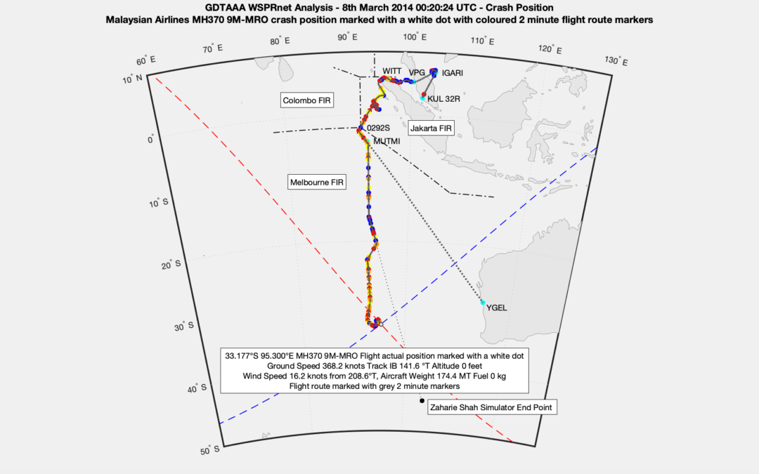
All 160 detections of MH370 using WSPRnet signals fit the Boeing 777-200ER performance and a flight path can be found that matches the ground speed and track at each detection point. The overall fuel range and endurance until fuel exhaustion also matches the known fuel on board and the Boeing 777-200ER speed schedules. The flight path matches all the Inmarsat satellite BTO and BFO data exactly. The crash location at 33.117°S 95.300°E is within the crash area determined by Prof. Charitha Pattiaratchi in his oceanographic analysis of the MH370 floating debris.
I am not delaying the technical paper because of my patent application.
Hello Richard, thank you for also announcing the corresponding sentence. No time delay due to patent filing is good news. Will the technical paper also answer some of the criticisms that have been raised?
@Zz,
I have been answering the criticisms from detractors on a regular basis on my website. No doubt there will be further criticisms.
The technical paper scope that I have agreed with Dr. Robert Westphal, Dr. Karl Herrmann and Dr. Petrus Johannes Coetzee is comprehensive. We include a history of WSPR related research, a review of the many scientific papers on WSPR, aircraft detection and related subjects, Physics for radio waves, the GDTAAA software, Radar Theory, Ways of propagation for WSPR in relation to MH370, How Primary and Secondary WSPR functions, etc. We hope to convince all sceptics and detractors and answer all criticisms.
Hello Richard,
I have a question about the turn at IGARI: Until now, it was assumed that this was very daringly flown manually. In the simulator, Malaysia was unable to replicate this turn while adhering to the 130-second time limit. Your route is more of a leisurely turn. What are your thoughts on this?
@Zz,
The ground speed of MH370 at 17:22 UTC at the start of the turn was 469.5 knots with a headwind of around 16.35 knots. After the turn the ground speed increased to 502.2 knots with a tailwind of around 16.35 knots. At an average ground speed of 485 knots with a bank angle of 15° it would take 5 minutes to turn 180°. I show the track changing by 228° in the 6 minutes between 17:22 UTC and 17:28 UTC. In my view, there is nothing special about this turn or any other turn in the MH370 flight path resulting from the GDTAAA WSPRnet analysis.
Hi Richard,
thanks, that’s interesting. The turn could therefore have been performed by a less experienced pilot. That was not nearly as close to the limit as previously assumed.
However, I am now wondering how does this square with the primary radar data? The Malaysian military claims to have observed the turnaround. I assume, based on this source, the MOT then had the 6 simulator sessions carried out.
Do you doubt the primary radar data and if so, for what period?
@Zz,
Since the Malaysian authorities have not published the raw military radar data, it is not possible for me to comment on it. It is not a question of doubting the existence or doubting the usefulness of the military radar data, it is simply a question of not having access to the data.
Malaysia military did not witness the turnback in real time. They had to look at the playback much later.
@All,
You cannot compare an aircraft and a volcano. Or so I thought, until Rob pointed out to me, that as far as WSPR is concerned it is just the opposite data: aircraft enhancement of spots, volcano depletion of spots.
The Tonga volcanic eruption on 15th January 2022 at 04:26:30 UTC had its epicentre at 20.54°S 175.38°W at a depth of 33 km.
Rob suggested I investigated WSPR links between Hawaii and New Zealand. I found 6 WSPRnet links that disappeared from 04:40 UTC onwards:
BK29cw – RF82dn
BL10rx – RE78js
BL10rx – RF70mb
BL10rx – RF81cu
BL10rx – RF82dh
RE68 mx – BK29
The first link to re-appear was BL10rx – RF81cu at 19:10 UTC, some 14 hours 50 minutes after it last appeared The other links re-appeared in the next hour.
In the narrow view, all the links listed above were affected:
https://www.dropbox.com/s/pkrlis1ggusgnpv/Tonga%20Volcano%20Narrow%20View.png?dl=0
In the wide view, all the links between Hawaii and Australia were unaffected:
https://www.dropbox.com/s/5vzmv36mle8wlai/Tonga%20Volcano%20Wide%20View.png?dl=0
The volcanic ash cloud was apparently up to 700 km in diameter.
I can understand your reluctance. It would not be easy to accuse the military of “unclean” surveillance. The last secured radar contact should then be over Pulau Perak at 18:02 UTC. According to your route, the Indonesian radar was not avoided afterwards, so “tracking” was possible. What motivation would Shah have had for this if he supposedly wanted to immerse himself in the SIO?
@Zz,
You make some good points and ask the question as to the motivation.
1. Last Radar Contact.
“The last secured radar contact should then be over Pulau Perak at 18:02 UTC.”
Not exactly.
The last civilian radar contact was at 18:00:51 UTC at 5.582566°N 99.183389°E, which is 29.3 km to the East of Pulau Perak on a bearing of 112.4°T. Boeing state the last 10 second radar contact was at 18:01:19 UTC, but do not give a position (see Malaysian Safety Investigation Report Appendix 1.6E page 1289). DSTG state the last 10 second radar contact was at 18:01:49 UTC, but do not give a position (see Bayesian Methods in the Search for MH370 chapter 4 page 17). I do not understand why Boeing and DSTG had different 10 second military radar data.
2. Indonesian Radar.
“According to your route, the Indonesian radar was not avoided afterwards, so “tracking” was possible.”
Not exactly.
The military radar stations in the region in 2014 had a comprehensive coverage. Unfortunately no raw military radar data has been made available publicly. In times when there is no perceived threat, many radar stations are switched off at midnight. It has also come to light that many of the Indonesian radar stations were not operational due to maintenance and repair measures and lack of spare parts. I have linked a map of the military radar stations and a report on the Indonesian radar installations (the report is in Indonesian but Google translate can be used to good effect). The pilot may have had inside knowledge that the Indonesian radar stations were not operating and that he could follow the coastline of Sumatra undetected. A relative of Shah worked at the Malaysian military academy.
https://www.dropbox.com/s/m1z34kw44blc69f/Regional%20Civilian%20and%20Military%20Radars%20capturing%20MH370.png?dl=0
https://www.dropbox.com/s/l0f68yscyvdg6xw/Indonesian%20Military%20Radar%20OPTIMALISASI-GELAR-HANUD.pdf?dl=0
3. Motivation.
“What motivation would Shah have had for this if he supposedly wanted to immerse himself in the SIO?”
I am not sure that the consistent objective throughout the whole flight was to make MH370 disappear into the SIO. There was a holding pattern for 20 minutes, which does not fit a scenario of getting as fast as possible and as far away as possible into the SIO. There was a period of 22 minutes between 20:10 UTC and 20:32 UTC where MH370 was heading towards Geraldton Airport in Australia. In 2014 the main runway at Geraldton Airport (runway 03/21) had a length of 1,981 m. A Boeing 777-200ER with a landing weight of 180 MT on a wet runway at an altitude of 348 m requires a runway length of 1,700 m. Geraldton Airport is the main diversion airport for aircraft unable to land at Perth Airport due to bad weather. The runway has meanwhile been extended to 2,400 m.
The final decision to head for the SIO appears to have been taken at 20:32 UTC around 4 hours into the flight. I have speculated that there might have been an attempt at a political negotiation to free the opposition leader Anwar Ibrahim. I have speculated that there might have been an attempt to seek political asylum in Australia. I do not know for sure the motivation for the disappearance of MH370, but Shah left his “finger print” on the actual flight path, which followed a track toward his home flight simulator end point at 45°S 104°E for 32 minutes between 21:54 UTC and 22:26 UTC.
If the flight data recorder is recovered, will it throw any light on why Shaw put the plane into a holding pattern and then flew it toward Geraldton?
@WB,
The flight recorder will only confirm the flight data, but not the reason why the flight route was flown.
If Zaharie tried to contact the authorities in Malaysia or Australia, would there be evidence in the flight recorders that he had done so?
HI Richard,
On page 14 of the GDTAAA Flight Paper It states:
“At 17:20 UTC MH370 is almost at waypoint IGARI and about to handover between the Singapore FIR (delegated to the Jakarta FIR) and the Ho Chi Minh FIR. There are six other aircraft in the vicinity, of which there are two candidate WSPR detections. ”
My guess is that what you intended to write is:
“At 17:20 UTC MH370 is almost at waypoint IGARI and about to handover between the Singapore FIR (delegated to Kuala Lumpur ACC) and the Ho Chi Minh FIR. There are six other aircraft in the vicinity, of which there are two candidate WSPR detections.”
I hope this is helpful.
@TommyL,
Many thanks and well spotted!
I have now corrected the paper accordingly and updated the download.
Hi Richard,
I’m a production coordinator and currently working on a show regarding to the MH370.
We would love to introduce your recent finding on our show.
I sent you an email last week. But, I’m not sure if my email went through…
So, I thought you might check the comments and find my message easier.
I would love to discuss more details. Please reply to my email or contact me at ru@gpausa.com
@Ru,
This is a scientific forum regarding MH370.
Please do not misuse the forum for media requests.
@WB,
You ask: “If Zaharie tried to contact the authorities in Malaysia or Australia, would there be evidence in the flight recorders that he had done so?”
Since the cockpit voice recorder only records the last 2 hours and then gets overwritten, I doubt whether there were any communications with Malaysia or Australia at this time during the last 2 hours of flight (22:20 UTC to 00:20 UTC).
The more likely time for any communications would have been much earlier during the holding pattern off the coast of Sumatra between 19:14 UTC and 19:34 UTC and any possible communications then would have been overwritten.
@Richard
“… at the start of the turn was 469.5 knots”
“…In my view, there is nothing special about this turn”
Beg to disagree, if I may.
What , entry into a standard holding pattern at almost full chat, I would suggest that makes it rather special. For one, it would not have been on automatics and for another, what possibly could the purpose been at that sort of speed. A hold is precisely that, just for a bit of time to wait and sort things out as necessary. That sort of stunt is not even performed by any civilian transport at international air shows.
A 30degree bank angle is pivotal in achieving a 180 standard 2min turn at 470kt gs, AP would restrict this to max bank of 25. The whole thing has the look of a F16 being squeezed around the turns, not the sort of thing done with a cabin load of pax in a B777 flown by your common or garden variety of airline pilot, I`d say.
@Tony,
You are misquoting me.
What I stated was: “The ground speed of MH370 at 17:22 UTC at the start of the turn was 469.5 knots with a headwind of around 16.35 knots. After the turn the ground speed increased to 502.2 knots with a tailwind of around 16.35 knots. At an average ground speed of 485 knots with a bank angle of 15° it would take 5 minutes to turn 180°. I show the track changing by 228° in the 6 minutes between 17:22 UTC and 17:28 UTC.”
The turn was at diversion, not as you state into a “holding pattern”.
The turn was at a bank angle of 15°, not as you state “A 30degree bank angle”.
The turn took 6 minutes to complete, not as you state “a 180 standard 2min turn at 470kt gs”.
First get your facts straight, then we can discuss.
@All,
Here is a link to a WSPR Technical Overview, which describes the key science and technology involved:
https://www.dropbox.com/s/454fh34g1483gcr/WSPR%20Technical%20Overview.pdf?dl=0
@ Richard
Please accept my apologies, I had no intention to misquote , I simply misunderstood the turn referred to.
Would it be correct that the reference is to the turn at IGARI,namely the turn back point to BITOD. If that is the case then there are discrepancies between ADSB and mil radar which claims an impossible sharp left turn having been performed. Somehow the evidence that has been put forward as factual seems dubious. In evidential terms, namely quality and reliability, I am inclined to consider this, the initial event as one of the crucial events and one which remains highly speculative and controversial.
Are there any WSPR detections for or in the vicinity of IGARI.
@Tony,
No worries!
I was referring to the turn back and diversion in the vicinity of waypoint IGARI.
The MH370 flight path aligns with the official ADS-B data until the aircraft transponder ceased.
The Malaysian military radar data has not been published, so I cannot comment.
There are 4 WSPR detections in the vicinity of waypoint IGARI, that I have previously published.
The MH370 aircraft detections and tracking aligns with the Civilian Radar data, the WSPRnet detections and the Boeing 777-200ER flight performance during the diversion.