Bill Tracy has written a paper entitled “New Interpretations of the Pilot’s Home Flight Sim”. In recent months, the ATSB has given analysts some guidance on the undisclosed portion of the MH370 pilot’s flight simulator cases. The new information leads Bill Tracy to believe the simulator flight path was an 180° South CMH to the Magnetic South Pole, and perhaps not to NZPG in Antarctica as originally thought. Bill concludes that the implication of an 180 South CMH path for MH370 is a crash latitude at around 32°S near the 7th Arc. This aligns with the drift analysis of Prof. Charitha Pattiaratchi, who also concludes that the most likely crash latitude is 32°S.
Bill Tracy’s paper can be downloaded here.
@Bill Tracy
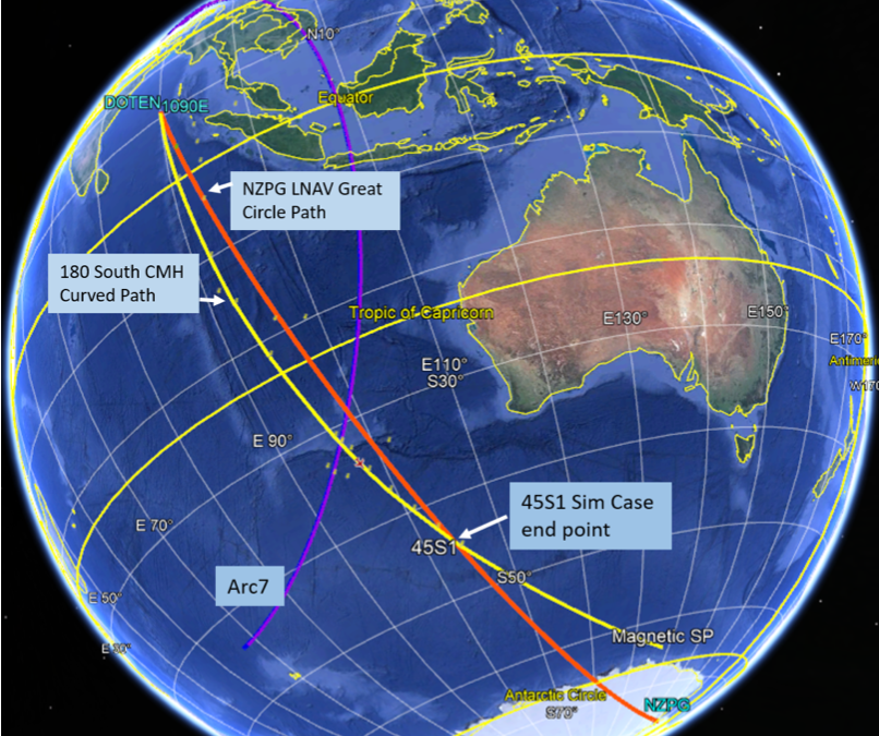
You state in your paper “It should be noted that we know MH370 probably did not go as far west as 1090E in real life. Therefore we might further speculate that the sim data represents a daytime flight plan circumventing weekday Indonesian radar coverage (eg; Sabang) and airspace.”
I have entered your flight path into my MH370 Flight Model and can confirm that MH370 did not go via 1090E as the BTO error at 19:41:03 UTC is very high. In addition there is the problem of matching the BFO during the first SATCOM call with a descent followed by a climb.
https://www.dropbox.com/s/0bu896vaz7qoe8u/Bill%20Tracy%20Flight%20Path%20CMH%20177%201090E.png?dl=0
I have also tried different start times from both 1090E or waypoint AMVUR (formerly DOTEN) with different speed schedule and altitudes but cannot find a flight path with BTOe and BFOe within their respective limits.
You mention that Bobby Ulich has shown several CMH/CMT curved paths with a reasonable goodness of fit in his 2018 paper. His preferred solution marked in green in the link below was a CMT 181.2 flight path, not a CMH flight path. The start locations for all his flight paths are all different to 1090E or waypoint AMVUR (formerly DOTEN).
https://www.dropbox.com/s/fg1zdtc14cwcu8m/BU%202018.png?dl=0
I appreciate you are trying to match the sim case at 10N, but I was trying to look ahead at what ZS did in reality with MH370. All I can say is that ZS must have done something different in reality.
Richard-
Thank you for the comments!
As you know, a long time ago Victor (plus you?) published a 180 South path that was “out and back” to LAGOG back to BEDAX. In past I have looked at how much further past LAGOG could MH370 have gone and still done the 180 South…and I think you can go a bit further out past LAGOG if you short cut down to ~ISBIX, but not too much further.
Your recent UIGB paper makes the point (for 180 South path) that it does not matter too much how you get to near-ISBIX, high and fast vs. descent and ascent, it al takes about the same fuel.
I must admit I do favor 180 South as how the flight path started, so when I said MH370 did not go out as far as 1090E, I am perhaps not being fair to slower flight paths like NZPG from VOCX, which is not in favor these days.
In general I am NOT proposing that MH370 went as far as 1090E. But I am proposing that that 180S CMH could have gave been the path shape starting from about ISBIX.
If you infer from the sim work, the pilot is active to the end of flight, and gliding. I see no reason why he might not have descended after Arc5, so I am not expecting 180S CMH has to be fit as a passive high altitude flight out to Arc7.
@TBill
(1) I agree that I wrote a paper together with Victor Iannello on 25th August 2016, that matched the satellite data. This paper can be found in the Archive section of this web site. However, this paper positions MH370 at 19:41:03 UTC a long way from 10°N 90°E at 8.5219°N 92.9501°E and never mentions going to waypoint LAGOG.
(2) I agree before that, I wrote a paper together with Don Thompson on 12th March 2016, that matched the satellite data. This paper can be found in the Archive section of this web site. However, this paper postulates a LNAV flight path to waypoint 30°S 90°E followed by a CMH after overflight of the last waypoint.
(3) I agree that more recently on 8th March 2020 I wrote a paper with Bobby Ulich, Victor Iannello and Andrew Banks which postulates a LNAV flight route to the geographic or true South Pole, that matched the satellite data.
(4) I am saying that your CMH flight path from 10°N 90°E or from waypoint ISBIX to the magnetic South Pole and even with a descent after the 5th Arc does not match the satellite data.
Interesting I will take a look at the Hybrid paper cited above, I do recall reading a hybrid paper, but I was thinking it was closer to 37 South end point.
@TBill
Why do you think it was, that the ATSB did not disclose the full information on Zaharie Shah’s home flight simulator? Were they trying to hide something?
For the obvious reason the sim data is highly suggestive of incriminating plan to hijack MH150. However, it is not ATSB hiding the data, it is Malaysia. FBI/ATSB are not at liberty to disclose data that Malaysia is keeping under “lock and key”.
Imagine if you will, if in 2016 when the sim data was finally leaked to the press, and it was highly sensational, if all of the sim data had been released, showing flight times to Jeddah etc.? That would have been incredibly damning.
Instead what we got was a partial leak of the sim data, with much room for doubt that the runs were indeed a coherent set. It took a couple of PhD’s (Victor/Yves) to prove the data were connected as a flight to the SIO.
Seems obvious to me when FBI gave Malaysia the data, they must have told Malaysia it was incriminating. Malaysia at first said it was nothing sinister, but I presume USA pressured Malaysia to say the truth, which in June_2014 Malaysia finally released to The Times that there was some question about a flight to the SIO in the sim data.
Lots of interpretation by me there, but that’s how I see it.
The RMP report on MH370’S pilot contain’s the RMP (Police) forensic examination of Zaharie’s simulator. It reveals that his simulator was attempting to operate a Posky 777 model on a 2006 FSX programe for Windows XP WHICH was only compatible with Windows 7 and that his simulator kept suffering software crashes. Actually there was nothing to hide because forensic evidence shows the simulator was inoperable. Every member of the Independent Group were shared copies of all the RMP reports (about five). So since the RMP reports contradict the pilot suicide accusations perpetuated by the Independent Group, perhaps it is the Independent Group who find it most convenient to conceal the simulator report?
I just now see Simon’s comment. I see apparent obfuscation/inaccuracy by Simon. The important point is that RMP Police report contains (1) the portion of the sim data that was leaked to the public and (2) apparently what the RMP police tried to interpret (wrongly). I say “wrongly” because we now know ATSB has a more complete version of the sim data. We still do not have the complete sim files (it is Malaysia’s property and it is undisclosed). We do not know why the RMP had an incomplete version of the data.
Just about nobody (including IG) likes the sim data, because we did not understand the sim data fully until about 2021. Most people/groups formed final opinions about MH370 back in 2014/2015. The sim data is like the flaperon, when found, contradicting all the prior assumptions, but there is refusal to accept the new evidence. Aside from denial, the second most important human weakness/mistake in analyzing MH370 is refusal to accept new evidence, once opinions have already been finalized, it is too late.
Bill, you said “We do not know why the RMP had an incomplete version of the data.”
Seriously ?
The Malaysians have never wanted to implicate the pilot.
Quite obviously, the RMP prepared report on the SIM was designed to achieve that outcome.
The Malaysians (publicly) and the RMP report (internally) are/is at pains to say that the SIM data is ‘not suspicious’.
It is hardly surprising then, that it would not include anything that may be incriminating, now is it.
“The truth – the whole truth – and nothing but the truth’ – does not apply, when the objective is to – ‘hide the truth’.
When the RMP was ‘leaked’, the whole world saw it’s contents.
The FBI saw it too, and they knew there was more info, and they knew what that info was, and it is fair to assume, that they knew precisely why the RMP report had not included that info. Consequently, they apparently felt it necessary to provide that ‘missing info’ to the ATSB ‘through the back door’ so to speak.
We now know that the ATSB has shared some or all of that extra info with the IG (presumably under some form of NDA).
@TBill
The ATSB state in The Operational Search for MH370 dated 3rd October 2017:
1. “Data from the Pilot-in-Command’s (PIC) home flight simulator was recovered and analysed in March/April 2014. This information was provided to the ATSB on 19 April 2014”.
2. “The simulator data was a partial reconstruction of a flight simulator session from 2 February 2014.”
3. “On 4 February 2014 the PIC was rostered to fly from Kuala Lumpur to Jeddah, Saudi Arabia. The first three data points recovered from the simulator were consistent with the route from Kuala Lumpur to Jeddah.”
4. “There were enough similarities to the flight path of MH370 for the ATSB to carefully consider the possible implications for the underwater search area. These considerations included the impact on the search area if the aircraft had been either glided after fuel exhaustion or ditched under power prior to fuel exhaustion with active control of the aircraft from the cockpit.”
It seems obvious to me from the timing of the simulation, the initial route of the simulation and the fuel load of the simulation that the initial target of Zaharie Shah was MH150 to Jeddah on 4th February 2014 and not MH370 to Beijing. ATSB obviously took the data found on Zaharie Shah’s home flight simulator very seriously.
Despite the insights you give to the fuel load, additional fuel loaded and fuel jettisoning, you make the excellent point that the final fuel load was exactly the fuel required to reach the magnetic South Pole, which on 8th March 2014 was at 64.304°S 136.709°E.
We agree the simulated route differs from the actual route flown by MH370.
You raise the key question as to why Zaharie Shah changed his mind between the simulator run on the 2nd February 2014 and the flight of MH370 on 7th/8th March 2014. We have discussed the 3rd pilot in the cockpit on the Jeddah flight, you point out the preference for a weekend flight where certain radar was not operational, you mention the choice of a night flight. Did these factors only come to mind for Zaharie Shah between 2nd February 2014 and the flight to Jeddah on 4th February 2014?
Did the choice of a flight heading East and diverting West across Malaysia appeal to Zaharie Shah as creating more confusion within the ATC?
Did the change from the magnetic South Pole to the geographic South Pole appeal to Zaharie Shah as creating even more confusion as to the ultimate end point and track followed by MH370?
Re: ATSB giving “serous consideration to the sim data”, that is interesting admission. But I do not think they gave enough consideration to it. Since 2017, I feel ATSB has been reaching out for “help” on analyzing the sim data for two reasons:
(1) ATSB realizes the sim data may have implications for the actual MH370 flight. We should not be conducting searches without complete analysis of the sim data, in my opinion. And we still do not know the complete data, or what else Malaysia/FBI knows.
(2) The second motive for OZ openness, since Mahathir’s regime in 2018, is Malaysia’s bad behavior denying MH370 was a Malaysian crime. I feel that Razak was being ultra-slow and careful, but cooperative with USA/OZ, my understanding the draft SIR report under Razak said possible pijacking or cargo issues. Mahathir came in and probably changed the final report to say Malaysia was not the cause of this accident, and some unknown outsider did this. Hence we now have vocal objections from eg; Tony Abbott, saying Malaysia knew it was likely pilot suicide.
PS- Thank you , you are first person asking the right questions
On the sim data, I agree that the runs are suggestive of a MH150 *or* MH168 flight to Jeddah. MH168 was redeye night flight to Jeddah that got cancelled. MH150 was supposed to shift to 11AM. These schedule changes did not happen, but I wonder if ZS maybe was originally scheduled on MH168? Just saying there was possibly a variety of take-off times for Jeddah he was looking at. I would like to know the actual calendar date the sim runs were conducted, and I am advised ATSB does not know that (since Oct 2017, we do know the time/date/season assigned in the simulator).
The flight to Jeddah in the simulator at FL400 could take as little as 52 KG fuel. I know people say the 68 KG might be close to what a commercial MAS B777-200LR would be loaded for Jeddah, with contingency fuel. I question if ZS is loading sim fuel for a “real world” flight to Jeddah – ZS knows what he needs in the sim and has no need to practice loading real world fuel amount. Also he adds more fuel at 5N so now we are up to 71-72 Kg fuel. To me he knows how to manage fuel and had no need to match that. He does seem to like the jettison step.
As far as flight MH370 management, I am thinking the high winds aloft below 22 South on 8-March might have prompted ZS to modify his plans. He might have just descended after Arc5, or switched to Track vs Heading (“hybrid” as you say), or even gone to Track or LNAV from the outset. Depending on the date you think the sim data was actually generated, the winds aloft were much lower more like 25 knots Fair Weather.
@TBill
Malaysian Airlines planned the service extension of an additional flight from Kuala Lumpur to Jeddah with MH168 in September 2013. The additional flight was to start from 28th January 2014 until 29th March 2014. The new flight was open for reservations on 6th September 2013.
The duty roster for Zaharie Shah contained in the RMP report has him clearly assigned to MH150 and not MH168.
Zaharie Shah was definitely only rostered to fly MH150 on 4th February 2014 and there is no mention of him in the duty roster being planned to fly MH168 at any time.
We only know what the actual flown duty roster was, correct? How would you know if there been a change of plan before that?
@TBill
The duty roster in the RMP report is the planned roster. As you can see it contains flights for Zaharie Shah after MH370 disappeared. He was planned to fly to DPS on 11th March 2014, HKG on 13th March 2014 and AMS on 20th March. All these future entries are with the default departure and arrival times.
For all the flights that had already taken place the duty roster is updated with the actual time of departure and the actual time of arrival.
If Zaharie Shah was unable to fly then the standby pilot would have been called in and the standby pilot would be allocated the actual flying hours. If Zaharie Shah had arranged a mutual swap with another pilot then it would be marked M. If Zaharie Shah was the standby pilot and had been called in then it would be marked SX-777 where X = 1 to 4 to denote the type of standby and the actual hours would be entered. There are no such entries in the duty roster of Zaharie Shah flying MH168 or doing a mutual swap with another pilot or being called in on standby to replace the pilot of MH168.
In any event, the fuel load for MH168 would have differed from the fuel load for MH150 only because of the expected weather en-route and availability of alternative airports. The difference would not be significant.
Interesting but I see nothing that precludes ZS planning for different flight times, ahead of the the final scheduling.
You are saying no evicdence of that, and we are in agreement. But we do not have confidential info about MAS planning and what might have been early schedule outlook. Much info we do not have from Malaysia, as you know.
@TBill
I appreciate that Zaharie Shah could set the Date Time Season in his home flight simulator to a different Date Time Season than the actual simulation session date.
ATSB are very clear that the simulator session to the SIO was dated 2nd February 2014, when Zaharie Shah was on a day leave as confirmed by the duty roster in the RMP report.
ATSB may not know the Date Time Season setting in the simulator for the session on 2nd February 2014, but we do know from the RMP report that other simulator sessions set the Date Time Season setting based on the current date at the time of the session.
Richard-
The *only* time fact we do know (disclosed by ATSB about Oct_2017) is the DateTimeSeason setting inside the simulator, 2-Feb-2014 1526-hrs
Via indirect contact, I have verified that ATSB does *not* know the actual time stamp of the saved files. Thus we must guess actual date the sim run was conducted, I would agree that it *might* make sense, or I cannot rule out, that it was also 2-Feb.
Agreed?
So that implies ATSB should not have said the runs were definitely conducted on 2-Feb, but OK the runs might have been run on 2-Feb.
@TBill
Did the ATSB simply assume the default values of the Date Time Season setting were not overwritten as was the case for other Zaharie Shah home flight simulator sessions?
On the other hand, is there any evidence that Zaharie Shah did not use the Date Time Season default setting for any of his many simulator sessions?
Richard- right now I am only focus on 2N, 3N, 5N, 10N, 45S. 45S2. I do not know about any other cases. Case 2N would be the start of the flight at KLIA. I understand the 2N file type is Previous Flight, which I think implies the simulator was turned off or a flight was ended and then restarted and resumed at 2N.
I wanted to know if the true time (file time stamp) is the same as the internal date and I am told that the file time stamp data is not available.
As you may know, there is an option to pick today’s time and date when you start a run, and you can change it.
@TBill
There are several other simulator sessions in the RMP report. Zaharie Shah kept buying external hard drives to keep all his data. In December 2013, January and February 2014, Zaharie Shah is recorded as running simulator sessions on 11 different days where he had the day off.
Richard- I agree that is interesting and possible.
When I do sim work, I almost never take off from KLIA.
I am always going back to a prior saved case to start.
It depends on why you are doing run though, sometimes I want to run exact time/date to see the night fall exactly same. Other times I just want the cockpit in light to see better.
Bottom line for me we are not looking at all of that data, and we cannot if we want to as it is being held secret. And we are not looking at what we have either. That is very frustrating to me and that’s why I tried to look at it again.
I feel like in Oct. 2017, we got the “bombshell” disclosure from ATSB that they have complete sim data, and we the public do not have. I feel the reason we got that 2017 admission from ATSB, was to help define search area.
However, at the same time, the new sim data got pre-empted with much breaking news: new OI search, Mahathir admin, SIR Report, ARA San Juan finding, IG change from 20-25 for next search to 34 South. So we just dropped the sim data implications.
“The routine for a 2P flight is generally the first bathroom break for each pilot occurs sequentially after the top-of-climb initial duties are complete. ”
Could this explain why Captain Zaharie Ahmad Shah, who was the Pilot in Command and the Pilot Monitoring at the time, did not make contact with Ho Chi Minh air traffic control as requested by KL ACC?
While out of the cabin some unplanned event may then have happened (loss of radar and communications) that caused the Pilot Flying, Fariq Abdul Hamid, either on his own initiative or under direction from the Pilot in Command, to turn the plane towards the nearest emergency airport.
Alternatively, it could simply be that the sudden loss of radar and communications meant that Captain Shah was not able to make contact with HCM.
@TommyL,
The first problem with the “some unplanned event” theory causing a diversion “to turn the plane towards the nearest emergency airport” is that no attempt was made to make an emergency landing at any of the airports passed en-route (Kota Bharu, Penang, Langkawi, Phuket, Banda Aceh, …).
The second problem is that we know from the Inmarsat satellite data that MH370 flew for a total of 7 hours 48 minutes. An aircraft experiencing some unplanned emergency event does not usually continue to fly for a further 7 hours.
Thanks Richard and good luck in the continuing search for the wreckage of MH370.
It looks as though WSPR data and GDTAAA are being very helpful in clarifying the “where” and the “when”, but that even after the wreckage is located and recovered there may still be significant unresolved questions about the “who”, the “why” and the “how”.
Other than the final descent, the three critical moments in the flight, as far as I can see, are
1. the moment that the flight ceased going as per flight plan, after about forty minutes,
2. the entry into the holding pattern and
3. the leaving of the holding pattern.
On reading the comment above by Mike, the idea that something mechanical might have gone awry after 35-40 minutes, while only the first officer, the pilot flying, was in the cabin seemed, to me, plausible and worth consideration.
re problem 1: I agree that it is difficult to understand why no attempt was made to land at any of the airports that were flown past.
But your comment caused me to wonder: How safe would it be to land a large passenger aircraft, pretty much full of fuel, at night, without satellite navigation or atc communications systems functioning, without the support of the local civil and military air services?
re problem 2: Given that, for whatever reason, no attempt was made to land, there was little option left for the pilots other than to keep flying, and hope that one of the local or international air or sea defence services would come to their rescue.
This is assuming that the pilot and co-pilot were totally unaware of the confusion between the different airlines and governments active in the region which delayed the declaration of an emergency for several critical hours after the plane failed to check in with HCM, ceased all communications, and stopped identifying itself as MH370.
As you say, “An aircraft experiencing some unplanned emergency event does not usually continue to fly for a further 7 hours.”
Such a scenario might arise if no better option is made available to the pilots.
While it may be that a decision to ditch the plane in the SIO was made while in the holding pattern, once it became apparent to the pilots that no help was forthcoming from Singapore, Australia, Malaysia, Indonesia or any of the navies in the region, the decision may simply have been to keep airborne, away from other flights and populated areas, for as long as possible.
Mike: thank you for your thoughts…
…the 2-man pilot crew of MH370 has been cited as one reason for choosing MH370 vs. say MH150 to Jeddah. MH150 seems to be the flight that the sim cases are based on. In the past, I have heard reference to MAS having a 3-pilot crew on MH150 (and not 4). There are also some other lesser known sim cases including one with with MH370 take-off time, but no further data was recovered.
My personal view is the sim cases are suspicious. The fact that MH150 was apparently being studied as a candidate flight for diversion to SIO should not be dismissed. If I am FBI, I would think I am advising Malaysia there was apparent plan to take MH150.
Yes we outside observers like to dismiss MH150. But that is possibly faulty logic. The sim data shows that apparently MH150 was under serious consideration. Correct logic would be to consider MH150 was indeed the plan, and now work that assumption, despite the extra pilot.
@TommyL,
The standard procedure is to select the closest airport with a runway of sufficient length, but before the emergency landing to dump fuel to ensure the aircraft landing weight is within limits.
At diversion the closest airport for an emergency landing was Kota Bharu, which would have required a holding pattern over the South China Sea to dump fuel.
I see no evidence that there was a holding pattern to dump fuel or an attempted emergency landing.
Hi Richard,
I agree that it looks as though no attempt was made at any time to land the plane.
“At diversion the closest airport for an emergency landing was Kota Bharu, ”
Looking at the flight path report, page 16, it could be that Hat Yai International (runway length 3050 metres) was the initially selected emergrncy diversion airport.
The turn to the south reported on page 17 of the flight path report followed by the turn to the south-west on page 18, would suggest that whoever was in control of 9M-MRO at this point (presumably the First Officer, as Pilot Flying, under emergency direction from the Pilot In Command) was now steering the plane towards Kota Baru and Penang.
What about the Port-au-francais (Kerguelen Islands) ? Couldn’t the Argos satélite Doppler system have caught the plane on its radar, which could be coordinated with the Inmarsat?
@Ty,
Welcome to the blog!
We have made some observations after doing research work into the SuperDARN (Super Dual Aurora Radar Network) data base in the Southern hemisphere.
The SuperDARN radars in the Southern hemisphere operate on HF and fulfil all the requirements such as higher Tx power, high gain antennas, even digital beam forming with up to 16 beams at numerous locations and range gating.
Data is available for the night 7th / 8th March 2014. There are 13 SuperDARN stations in the Southern Hemisphere including the French “Centre National de la Recherche Scientifique” (CNRS) based on the Kerguelen Islands.
@Simon Gunson,
The Royal Malaysian Police (RMP) Forensic Lab Preliminary Inspection Report shows that the home flight simulator of Captain Zaharie Shah was successfully used for a large number of flight simulations and over an extensive period of time.
Captain Zaharie Shah had X-Plane 10 from Laminar Research, Flight Simulator 2004 (Version 9) and Flight Simulator 2006 (Version 10 or X or FSX) from Microsoft, which he ran on Windows XP or Windows 7 (Ultimate Edition) as appropriate.
The forensic report states that Captain Zaharie Shah used the Phoenix Simulation Software (PSS) Boeing 777-200LR aircraft simulation in the Malaysian livery without the Virtual Cockpit. There is no record in the forensic report of Captain Zaharie Shah using the POSKY 777 (Project Open Sky Boeing 777) model as you falsely claim.
The forensic report states that the co-ordinates recovered from the MK26 Corsair Force 240 GB SDD external hard drive .FLT files were generated using the Phoenix Simulation Software version of the Boeing 777-200LR, which runs on Microsoft Flight Simulator 2004 (Version 9) and Microsoft Windows XP:
“[Plane. 0] Aircraft=PSS Boeing 777-200LR Malaysia No VC”
The software crashes experienced by Captain Zaharie Shah were all related to using the Steam Edition of Microsoft Flight Simulator 2006 (Version 10 or X or FSX) on Windows 7. The forensic report shows the crash report:
“fsx.exe version 10.0.61637”, which is the Steam Edition of Microsoft Flight Simulator 2006 (Version 10 or X) and called FSX for short.
“uiautomationcore.dll version 7.0.0.0”, which is the Windows 7 dynamic linked library where the crash occurred.
This has nothing to do with the successful usage by Captain Zaharie Shah of Microsoft Flight Simulator 2004 (Version 9) on Windows XP with the Phoenix Simulation Software (PSS) Boeing 777-200LR aircraft simulation, which you misleadingly contradict.
The forensic report states that 668 .FLT files were found on four different external hard drives revealing a large number of flight simulations with a variety of different aircraft including the Boeing B777L, Boeing B738 and the Douglas DC3.
The forensic report states that the RMP reproduced the simulator using the Microsoft Flight Simulator 2006 (Version 10 or X or FSX) on Windows 7 using the PMDG Boeing 777-200 LRX. Why they did not use the same software as Captain Zaharie Shah with the Microsoft Flight Simulator 2004 (Version 9) on Windows XP with the Phoenix Simulation Software (PSS) Boeing 777-200LR aircraft is not explained in their report.
To state that the “forensic evidence shows the simulator was inoperable” is complete nonsense.
The Independent Group (IG) issued four reports publicly on MH370 and all were published in 2014 before the RMP report was leaked in 2016. The work of the IG is acknowledged by the ATSB in their final report dated 3rd October 2017: “The ATSB acknowledges the extensive contributions that many individuals and groups have made during the underwater search for MH370. Many contributors have provided credible, alternate and independent approaches and analysis of the limited data available. In particular, the ‘MH370 Independent Group’ comprised of scientists, researchers and individuals who have cooperated across continents to advance the search for MH370. The ATSB is grateful for their work collectively and individually including Duncan Steel, Mike Exner, Victor Iannello, Don Thompson, and Richard Godfrey. The ATSB also acknowledges the extensive and detailed contributions provided by Simon Hardy, Bobby Ulich and Robin Stevens.”
After the RMP report was leaked the IG published a report titled “Captain Zaharie Shah’s Recovered Flight Simulator Information: Preliminary Assessment from the MH370 Independent Group” by Victor Iannello, Don Thompson, Michael Exner, Richard Godfrey, Brian Anderson, Yap Fooh Fah, Barry Carlson, Thomas Kenyon and Duncan Steel and dated 14th August 2016, where we specifically state: “We have no comment on whether this evidence links Captain Zaharie Shah to a crime.”
This was followed up by a further report titled “Further Analysis of Simulator Data Related to MH370” by Victor Iannello and Yves Guillaume and dated 29th November 2016, where they state: “The totality of the evidence suggests that it is likely that a user created a simulation on Microsoft Flight Simulator to create a flight that passed over the Malacca Strait to the Andaman Sea and to the SIO in a way that is similar to the flight path that investigators believe was followed by MH370.”
Your false accusation that “pilot suicide accusations (are) perpetuated by the Independent Group” is complete nonsense.
Your false accusation that the IG sought to conceal the simulator report is also complete nonsense.
Any continuation of such false and misleading information will result in you being banned from this website.
@ventus45,
You say “We now know that the ATSB has shared some or all of that extra info with the IG (presumably under some form of NDA).”
The ATSB has shared some, but not all, of that extra data with the IG and separately with Mick Gilbert, who in turn shared the information with Mike Glynn. There was no NDA involved with the IG regarding the simulator data. The ATSB initially assumed that the RMP data was identical with the FBI data. The IG found out that there were several pages missing in the RMP data, when compared to the FBI data, by sharing what we had with the ATSB.
I agree with your assessment that the Malaysian authorities did not want to publicly or privately state the whole truth and that “The truth – the whole truth – and nothing but the truth’ – does not apply, when the objective is to – ‘hide the truth’.
@Richard,
Thank you for your response.
I searched back through Reddit, and found this:
Australian officials warned families of MH370 data leak from FBI
https://www.reddit.com/r/MH370/comments/4uqhfs/australian_officials_warned_families_of_mh370/
Given the time that elapsed, can you clarify Duncan Steel’s comments, and anything else contained in that article please.
@ventus45,
You quote from a comment in Reddit, dated 8 years ago in 2016, by someone using the pseudonym “pigdead”.
The IG members and Jeff Wise (who was thrown out of the IG in 2015 for publishing our data in a magazine article) were separately given the RMP folders on 25th July 2016 by an intermediary acting on behalf of the source in Malaysia. The intermediary requested confidentiality. The IG respected the confidentiality, but Jeff Wise published the data in the New York magazine.
The documents are from the RMP and not from the FBI. The FBI did analyse an external solid state hard drive from the home flight simulator of Capt. Zaharie Shah on behalf of the RMP. It is a documented fact, that the ATSB has several pages more data from the FBI, than is included in the RMP report regarding this external solid state hard drive from the home flight simulator of Capt. Zaharie Shah.
The IG members and Jeff Wise know the identity of the intermediary, but were asked to keep that confidential, because it would likely reveal the Malaysian source.
Despite the time that has elapsed since 2016, revealing the identity of the intermediary would still reveal the source, so confidentiality is still required. Suffice to say that, in my view, the RMP folders are genuine as far as they go, but are incomplete compared with the FBI data provided to the ATSB.