Was the Malaysian Military Radar data released by Geoscience Australia?
In a recent paper, written by Capt. Patrick Blelly, Jean-Luc Marchand and an anonymous source called trise5631@gmx.com they claim that the Malaysian military radar data has been released by Geoscience Australia.
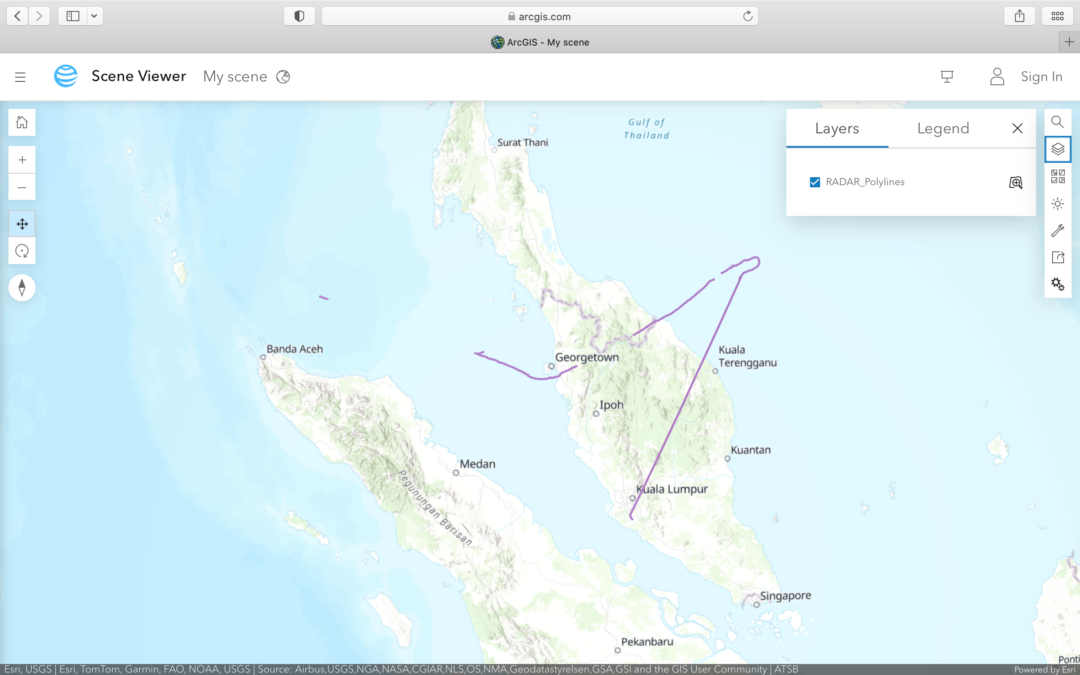
I contacted trise5631 and was kindly shown how to download the data. There are two files called RADAR_Polylines and RADAR_Points. How to download the files and an analysis of the data can be found in the paper here
In each case you will receive the JSON files that are used in ArcGIS, with the organisation licence ATSB, to build the ESRI vectorial map layers on the Geoscience Australia website.
If you Google “arcgis radar_polylines” and “arcgis radar_points” you will get descriptions of the data.
Both data items were created on 20th April 2017 and are owned by Geoscience Australia, but with Credits (Attribution) ATSB. They are layers that support the generation of the story map application “The data behind the search for MH370” on the Geoscience website.
It is clear from the descriptions, that the positions are “indicative only” and the layers are designed to support the generation of the story map application “The data behind the search for MH370” on the Geoscience website. The data files have been viewed over 145,000 times since their creation on 21st April 2017. The files have been updated in May and July 2017.
These are files supporting a Geoscience Australia website graphic and are not a Malaysian military radar official data release. The data is 7 years old and not a new disclosure. The data has been viewed over 145,000 times and is not a newly divulged secret.
The RADAR_Polylines JSON data is not consistent with the RADAR_Points data.
The RADAR_Polylines JSON data is not consistent with the ACARS Position Reporting data and ADS-B data available from MH370 up until diversion and is not consistent with the Civilian Radar data from Kuala Lumpur International Airport TAR, Genting RSR, Kota Bharu Airport TAR or Butterworth AFB Penang Airport TAR either before or after diversion.
Unlike the ACARS, ADS-B and Civilian Radar data, the JSON files contain no timestamps. This is because the JSON files were only designed to support maps and not a release of radar data.
The existing ACARS, ADS-B and Civilian Radar data are still valid and this 2017 data is simply a graphical input to produce a map on the Geoscience Australia website.
@All,
A new article by Geoffrey Thomas titled “MH370 Military Radar Claim Debunked” can be viewed at the following link:
https://www.airlineratings.com/news/mh370-military-radar-claim-debunked/
Mr Godfrey said that “these are files supporting a Geoscience Australia website graphic and are not a Malaysian military radar official data release. The data is 7 years old and not a new disclosure. The data has been viewed over 145,000 times and is not a newly divulged secret.”
@All,
An article in “The Parisien” newspaper by Paméla Rougerie.
The title in French is: “Vol MH370 : origine des données, thèse du suicide… Que penser du nouveau rapport de chercheurs français ?”
The title in English is: Flight MH370: origin of data, suicide thesis… What do you think of the new report from French researchers?”
You can read the article in the original in French at the following link:
https://www.dropbox.com/scl/fi/u4m978zlduktnuicsvnh0/Le-Parisien-Pam-la-Rougerie-22APR2024-French.pdf?rlkey=ueme9li9etw0tek1kvcbqq4za&dl=0
You can read the article translated into English at the following link:
https://www.dropbox.com/scl/fi/1l4me4nadgo9wni4vxtyd/Le-Parisien-Pam-la-Rougerie-22APR2024-English.pdf?rlkey=go4lfr2x9edznvw5dnbsb0anm&dl=0
@All,
Here is a new paper titled “Geoscience Australia data is not from the Malaysian Military”.
https://www.dropbox.com/scl/fi/s0h6dntvz1ldhu6svkwnj/Geoscience-Australia-data-is-not-from-the-Malaysian-Military.pdf?rlkey=yxfa7z2py2oia36b9ktvaxlwz&dl=0
Here are the key findings:
Military radar data has a date-time stamp, the Geoscience data does not.
Military radar data is a chronological stream, the Geoscience data is not.
Military radar data has major gaps, the Geoscience data does not.
Military radar raw data does not contain repeats, the Geoscience data has 38 repeats.
Military radar raw data does not contain additions or fillers, the Geoscience data has been redacted.
Military radar data was shown to the NOK in 2014, the Geoscience data does not use this data.
Civilian radar data was released in 2015 and since updated, the Geoscience data matches.
Civilian radar and ADS-B data contains 4,808 rows, the Geoscience data is a subset of 500 rows.
The Geoscience data is for illustrative purposes only, for MH370 flight path graphics on their website.
Here is the backing data.
https://www.dropbox.com/scl/fi/u6o8d3ffpdx4ur95d4q2t/MH370-KLIA-Genting-Kota-Bharu-Secondary-Radar-Data.xlsx?rlkey=oanje5z5sar3xi8298kn0d6v7&dl=0
https://www.dropbox.com/scl/fi/ah50w6xxl4iky8yw1yonz/MH370-ACARS-SITA-SU-Log-Decoded.xlsx?rlkey=xzsgvikqyd3kem270jkbtp1hn&dl=0
https://www.dropbox.com/scl/fi/2ubbsg0fdg1vvc1o0j9fq/ADS-B-Terengganu-Export.xlsx?rlkey=6m1wh2it11wqu4cb3r9yhssu1&dl=0
https://www.dropbox.com/scl/fi/4facmbe5jn79ajta6mda7/MH370-Kota-Bharu-Butterworth-Primary-Radar-Data.xlsx?rlkey=7i2maezsilv21s9our3my2ytw&dl=0