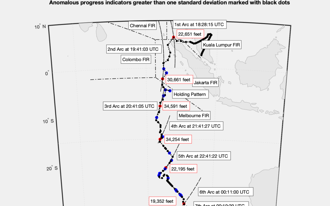
MH370 crashed between 00:22 UTC and 00:27 UTC. At 00:22 UTC the position from the WSPRnet analysis was estimated to be 30.00°S 98.70°E. At 00:26 UTC the position from the WSPRnet analysis was estimated to be 30.57°S 98.75°E. The crash location is further north than previously thought and up to 42 nmi South East of the 7th Arc.
We have presented evidence that there was an active pilot until the end of the MH370 flight. We have also presented evidence that the pilot may have been disoriented, which can be caused by hypoxia.
To solve the mystery of the disappearance of MH370 we need to find the aircraft and recover the Flight Data Recorder and other evidence from the wreckage.
The new paper can be downloaded here
Statement
We have presented evidence that there was an active pilot until the end of the MH370 flight. We have also presented evidence that the pilot may have been disoriented, which can be caused by hypoxia.
I am on the record publicly as stating that my private opinion is that the pilot was Captain Zaharie Shah. I have always made it clear that this is based only on circumstantial evidence and is not proven.
This is not my public opinion, where I have always talked about the pilot without naming anyone.
I am also on the record publicly as stating that the circumstantial evidence against Captain Zaharie Shah would not hold up in a court of law.
To be clear the home flight simulator of Captain Zaharie Shah shows an accelerated simulation to fuel exhaustion in the southern Indian Ocean based on the fuel available for a flight to Jeddah and not to Beijing. The simulation is not a flight route, but only a fuel check. This cannot be used as evidence in court of a planned flight to fuel exhaustion in the southern Indian Ocean. This is not evidence of a premeditated hijacking and murder suicide. This is like someone being handed a smoking gun and then being accused of being the murderer.
To solve the mystery of the disappearance of MH370 we need to find the aircraft and recover the FDR and other evidence from the wreckage.
@ Richard
Your statement and the paper are both excellent !
The WSPR crash site fits within Prof. Pattiaratchi’s UWA drift analysis, which identified the origin of MH 370 debris at between 28°S and 33°S. That drift analysis accurately predicted where and when MH 370 debris would arrive, and led me to find and collect from local people many pieces of the plane.
Search On, and let’s find the rest of the plane, the truth, and the proof !
Hi Mr Richard
I’m ENG. Hassan Al Hilali from SD
MH370 is the method of finding and rescue should be touts for all world aviators and it test if we’re capable to transform true informations to the public, I’m like so many others I do fully concerned about the full knowledge of mh370, to answer the questions where did it go?
-I make in my openion wsper net work is not enough to give the opportunity to reach the mh370.
– Mr Godfrey suggested hypoxia, I support him.
Reguards.
@Hassan Mohamed Osman
Welcome to the blog!
WSPRnet data matches:
(1) The Inmarsat satellite data.
(2) The Boeing fuel data.
(3) The Oceanography drift analysis.
Thank you for your support on the possible pilot disorientation. There are 64 occurrences of pilot disorientation in the Aviation Safety Network database. Hypoxia is one possible cause of disorientation.
Good Afternoon Mr. Godfrey,
Thank you for sharing the insights in this detailed report.
May I ask about the updated location of where the “holding pattern” happened…
Do you think this new location, more off from ground/airports, and new shape (“flatter” than the oval outlined before) can yield different predictions on its cause(s) ? Or do they no matter?
Like, in contrary to the rather popular prediction that claim the pilot “might had been negotiating with people on the ground”, can the pilot “accidentally” activate the holding pattern, given he was “disoriented”?
I am no expert in aviation so I am just asking, sorry.
Thank you for your time and a response from you will be very appreciated.
-Dustin
To my knowledge only 2 waypoints in the southern indian ocean was found on Shah´s simulator. And they were right next to each other. How do you connect that with any route? Or know that they were meant to be end points?
@Henrik,
Welcome to the blog!
Shah used Microsoft Flight Simulator X (FSX) and Microsoft Flight Simulator 2004 (FS9). Shah used an add on from Phoenix Simulation Software for the Boeing 777-200ER aircraft (PSS Boeing 777-200LR No VC) which only runs with FS9. There were 91 flight plans and 671 simulated flights found on 5 hard drives.
The initial part of the flight simulation to fuel exhaustion in the Southern Indian Ocean, found on one of the hard drives called MK25, followed the following waypoints and flight routes WMKK AGOSA R467 GUNIP B466 TASEK and VAMPI.
The full flight has been replicated on FS9 with the PSS Boeing 777-200LR using WMKK, AGOSA, GUNIP, TASEK, VAMPI, MEKAR, NILAM, IGOGU, LAGOG, DOTEN/-30 and NZPG.
FSX currently has 81 airports, 705 navaids and 16,219 waypoints in the Indian Ocean Region. I had no problem to find waypoints such as ISBIX, SELSU, KETIV, ELATI, PIBED, RUNUT, etc. Most of these waypoints would have been available in 2014.
You do not have to use standard waypoints, you can also create custom waypoints. In fact you do not have to use waypoints at all, you can use a flight path defined by a heading or a track based on either a magnetic or true compass bearing. An active pilot could enter a heading or track at any time during the flight on the Mode Control Panel.
The simulation recovered from deleted files on Shah’s computer to fuel exhaustion in the Southern Indian Ocean shows that the aircraft was manually positioned along the flight path. The data files were manually created and a number of parameters were manually changed. The data points share some of the same values suggesting the flight files came from the same simulated flight (or more precisely a simulation of a simulation).
When a great circle path that connects the points found along the flight path is extended past the final points, the great circle path aligns with waypoint NZPG which is McMurdo Station, Antarctica.
I co-authored a paper on the subject back in 2016:
https://www.dropbox.com/s/fqld93pw00hxvav/2016-08-25%20MH370%20Path%20Towards%20McMurdo%20Station.pdf?dl=0
All the ‘experts’ I have discussed the final resting place of MH370 with insist on a northerly location for the remains. This is incorrect! It is south of the existing searched area!
@Mickey Smiths,
Welcome to the blog!
I disagree with your contention in your recent video, that MH370 is at 40.5°S 86.9°E for the following reasons:
1. How do you explain someone making an unauthorised entry to the MEC when the hatchway is under the floor carpet in the forward galley? Anybody trying to do that would be observed. In any case, there is no need because the cockpit overhead panel has all the switches and contact breakers required.
2. What evidence is there for dramatic changes in altitude following diversion?
3. Why is it necessary to avoid Banda Aceh airport radar, when it is was not operational at that time?
4. You say there was a soft ditching on water. You also say the flaps were not extended. Why do you think that the standard procedure of partially extended flaps was not followed, as for example in the Hudson River ditching.
5. You say the Captain’s home flight simulator shows an altitude of 40,000 feet, but that was only at 10°N. At 45°S the altitude was shown as 37,651 feet.
6. You say that MH370 glided 215 km, but that would take around 14 minutes. How do you explain the absence of the IFE connection transmission expected at 00:21:06 UTC around 90 seconds after 00:19:37 UTC?
7. How do you explain the analysis of the BFO data by Ian Holland of the DSTG which shows an accelerating rate of descent of between 14,800 fpm and 25,300 fpm at 00:19:37 UTC?
Here is chart of the underwater location:
https://www.dropbox.com/s/t0raxweo4aangon/ATSB%202014%20North%20of%20Broken%20Ridge.png?dl=0
Here is a link to a comparison between the latest MH370 flight route and the previous one from last year:
https://www.dropbox.com/s/9qux4ei5d6d5ns7/GDTAAA%20MH370%20Flight%20Path%20New%20and%20Previous%20Comparison.png?dl=0
A new article by Geoffrey Thomas at airlineratings.com:
https://www.airlineratings.com/news/refined-study-pinpoints-location-of-mh370/
In a follow up article, Geoffrey Thomas discusses the possibility that the pilot may have been disoriented due to hypoxia:
https://www.airlineratings.com/news/mh370-pilot-may-have-been-disoriented-new-study-finds/
Hey Richard 6,
The work you did there is just wonderful! It really seems like this time, we´re on the right path!
6 questions , which will probably answer all of the questions from the MH370 community:
1. Does the new calculated WSPR Route fit to the KNOWN part of the flight path at the border of the malaysian radar control? ( Important to prove the validity of the improved WSPR version)
2. Has the location you found out to be the plane´´s final resting place been searched yet? ( e.g. by Ocean Infinity in 2018?)
3. How does this new reseach affect Ocean Infinitiy´s planned seach for 2023?
4. How come that theres such a big difference in terms of the flight path and the crash spot in comparison to the first WSPR flight path?
5. Are sure that this time you have really found the planes final resting place?
6. Are you in contact with the ATSB? If yes, maybe they could review their old data belonging to the area you predicted, just like they did in march/april of 2022
Thank you for incredible effort!
Yours Sincerely
Fabian
@Fabian,
Many thanks for your comment and very good questions. Here are my responses:
1. Does the new calculated WSPR Route fit to the KNOWN part of the flight path at the border of the Malaysian radar control?
The new route fits the civilian radar from Butterworth Air Force Base for the Penang Airport area exactly, which is available up to 18:00:51 UTC.
There is a single military radar detection at 18:22:12 UTC, but the raw data has never been released. There are two conflicting definitions of the position of MH370 at 18:22:12 UTC:
– The Malaysian Military presented a slide to the NOK at the Beijing Lido shows the position was 200 nmi from Butterworth on a bearing of 295°T, which would position MH370 at 6.871123°N 97.354047°E.
– The Malaysian Safety Investigation Report shows the position was 10 nmi beyond waypoint MEKAR on flight route N571 toward waypoint NILAM, which would position MH370 at 6.577655°N 96.340864°E.
These two positions are 116.6 km apart.
The DSTG decided not to use this single military radar detection for two reasons:
– The radar data is less accurate at long range.
– The radar data is not consistent with the Inmarsat satellite data at the 1st Arc following the SDU reboot at 18:25:27 UTC, even at 18:28:15 UTC after the SDU satellite data had settled.
Both the previous and the current GDTAAA and WSPRnet analysis matched each of the Inmarsat satellite BTO and BFO data points from 7th March 2014 18:28:15 UTC up until the last data point on 8th March 2014 at 00:19:37 UTC.
2. Has the location you found out to be the plane’s final resting place been searched yet? ( e.g. by Ocean Infinity in 2018?)
Ocean Infinity only searched 22 nmi either side of the 7th Arc in this area. The new crash location is near the estimated position given by GDTAAA and the WSPRnet data at 00:26 UTC of 30.57°S 98.75°E and is outside the previously searched area at a position approximately 42 nmi South East of the 7th Arc.
3. How does this new research affect Ocean Infinity’s planned search for 2023?
Ocean Infinity have been kept fully informed of this update. The new crash location at around 30.57°S is very close to the centre of the area defined by Prof. Charitha Pattiaratchi which is 30.5°S and between 28°S and 33°S as determined in his drift analysis. It was this drift analysis that correctly predicted where Blaine Gibson should look and would discover 20 items from MH370. In total 36 items of MH370 floating debris have been recovered and analysed by the authorities.
Ocean Infinity are determined to search until they find MH370. Their new technology allows them to efficiently cover a large underwater search area and well beyond what has previously been announced to the NOK on 6th March 2022 and the Malaysian authorities on 20th June 2022.
4. How come that there’s such a big difference in terms of the flight path and the crash spot in comparison to the first WSPR flight path?
There is a significant difference in allowing SNR anomalies only equal or greater than one standard deviation (SD) compared with previously allowing SNR anomalies equal or greater than 0.25 SD. We have shown in section 13 of the new paper that there is likely valid information in SNR anomalies equal or greater than 0.75 SD. SNR anomalies between 0.25 SD and 0.75 SD have been discarded as not providing reliable information and this has led to the change in track. This change in handling the SNR anomalies has been made following a suggestion by Prof. Simon Maskell. He is familiar with the details of our work and independently using the WSPR data in an analysis of the MH370 flight path as well as more generally to ascertain its usefulness to detect and track aircraft.
The following comparison between the previous and the current flight path shows broad agreement despite the significant changes in GDTAAA over the last 9 months:
https://www.dropbox.com/s/9qux4ei5d6d5ns7/GDTAAA%20MH370%20Flight%20Path%20New%20and%20Previous%20Comparison.png?dl=0
The major divergence between the flight paths occurs after the 5th Arc, where the flight path previously continued in a more southerly direction, which in turn resulted last year in a crash location 2.6° of latitude further south. The crash location has moved 436 km further North-East, but the Indian Ocean is 70.56 million km2 and this is a relatively small difference.
Boeing, Inmarsat, ATSB, DSTG, Mick Gilbert, Captio, Ed Anderson, Victor Iannello and UGIB have all presented analyses of MH370 of the flight of MH370 following straight lines:
https://www.dropbox.com/s/kpsh92ihs6xghwj/Straight%20Line%20or%20Not%3F.pdf?dl=0
Mike Exner first pointed out in his paper dated 26th April 2014 that the BFO data from the 2nd Arc to the 6th Arc followed a straight line. This was followed by an Inmarsat paper dated 4th September 2014 showing that the BFO data from the 2nd Arc to the 6th Arc followed a near straight line and the BTO data followed a smooth curve resulting in a straight line flight path for MH370. Both ignored the granularity of these 5 data points was every hour and a lot could happen in between.
https://www.dropbox.com/s/i162alunk28yupp/BFO%202nd%20Order%20Polynomial%20Trendline.png?dl=0
https://www.dropbox.com/s/24fjaqojix92sce/BTO%203rd%20Order%20Polynomial%20Trendline.png?dl=0
Niels Tas was the first MH370 analyst to consider curved flight paths in his paper titled “Python based implementation of MH370 explicit path generation employing polynomial fits to BTO and BFO derived input data” dated 21st February 2021.
We have shown, with the much improved granularity of the WSPRnet data (77 WSPRnet data points versus 7 Inmarsat satellite data points), that the flight path was anything but a straight line and much more like a zig zag flight path. Using GDTAAA and the WSPRnet data is more like taking a video as opposed to a few photos. This zig zag flight path raises the question whether the pilot was disoriented, because of all the turns up to every 8 minutes during the flight, coupled with times up to 32 minutes under autopilot in straight flight.
5. Are you sure that this time you have really found the planes final resting place?
In science there is nothing sinister in updating techniques and thus results where appropriate. It happens all the time due to the improvements in technology and further development and refining of techniques. Just look at how far carbon dating has come. In the early days there were some serious outliers in the carbon dating results but nowadays it is accepted as a very valuable science. And all of this happened because of continuous improvements.
I expect a continuous improvement in our GDTAAA software and the WSPRnet method. Kaizen is a compound of two Japanese words that together translate as “good change” or “improvement.” However, Kaizen has come to mean “continuous improvement” through its association with the lean methodology and associated principles. We follow these principles of continuous improvement.
6. Are you in contact with the ATSB? If yes, maybe they could review their old data belonging to the area you predicted, just like they did in March/April of 2022.
The ATSB kindly provided flight data to support the testing of the GDTAAA software and WSPRnet based detection and tracking of AMSA search aircraft between Pearce Air Force Base and the MH370 search area in March and April 2014 timeframe under a confidentiality agreement.
The ATSB did not cover this newly defined search area in their original underwater search in 2015 and 2016, although the area was partially covered in their underwater survey in 2014.
The area was only partially covered by Ocean Infinity in 2018 up to a distance of 22 nmi from the 7th Arc, but the crash location is more likely up to 42 nmi from the 7th Arc as explained in the answer to question 2 above.
Thank you so much for the detailed answers!
@All
Fabian’s good questions and my answers have been posted on Airlineratings.com by Geoffrey Thomas:
https://www.airlineratings.com/news/new-mh370-location-report-clarified/
@All,
Prof. Charitha Pattiaratchi and Ems Wijeratne published their drift analysis in an article titled “Ocean currents suggest where we should be looking for missing flight MH370” in “The Conversation” dated 28th July 2016.
On 29th July 2015, more than 16 months after the flight disappeared, a section of a wing – a flaperon – washed up on Reunion Island in the western Indian Ocean. This was later confirmed as originating from the MH370 aircraft. The authors actually predicted this discovery using an oceanographic drift model 12 months in advance.
The authors from the University of Western Australia (UWA) used the surface currents predicted by the HYCOM global ocean model as input to a particle tracking model to track debris over a 16-24 month period to coincide with the finding of the flaperon on Reunion Island. The origin of the debris was specified along the 7th arc at 25 different locations extending from the south (-39.258298°S 87.515653°E) to north (-22.815421°S 103.829706°E). For each model run, 50,000 particles were released and tracked over the period 8th March 2014 to 28th July2015.
The authors report the results as showing the MH370 crash location was between 33°S and 28°S in the region of the 7th Arc and in a wide area either side of the arc. The article states: “These results from the oceanographic drift modelling indicate that in terms of the timescales involved in the transport of the debris to Reunion Island the most likely location for the origin would be between locations 11 (33.171678°S, 96.294832°E) and 18 (28.297439°S, 100.503580°E).”
The authors also note: “These results are consistent with recent predictions by an independent Italian group using similar modelling techniques.” As further MH370 floating debris was recovered the authors updated their findings in subsequent articles, but maintaining that the crash location was in a wide band around the 7th Arc between 33°S and 28°S. The recent GDTAAA results based on the WSPRnet data indicate a crash location between 30.00°S 98.70°E and 30.57°S 98.75°E and up to 42 nmi South-East of the 7th Arc are in alignment with this drift analysis.
Blaine Gibson first visited Prof. Charitha Pattiaratchi on 3rd September 2015. Based on the advice received at that meeting Blaine Gibson visited Mozambique and Madagascar. Blaine Gibson eventually found 20 items of floating debris from MH370. I believe Blaine Gibson made genuine finds of MH370 debris, as did Johny Begue, Schalk Lückhoff, Neels Kruger, Liam Lotter, Milson Tovontsoa, Rija Ravolatra, Eodia Andriamahery, Jean Dominique, Suzy Vitry, Barry McQade, Jean Viljoen and others. Many items of debris have been confirmed or are likely to have come from MH370. That these items of debris were flown intact to Kazakhstan, then subsequently damaged to simulate a crash, then subsequently exposed to marine life for a month and finally planted in 27 locations in 7 countries for 14 different people to find, is preposterous nonsense.
@All,
A new article “MH370 Tracking Expert Debunks New Critical Report” on airlineratings.com by Geoffrey Thomas:
https://www.airlineratings.com/news/industry-news/mh370-tracking-expert-responds-to-a-recent-paper/
@Dustin Lo,
Welcome to the blog!
The new location of the holding pattern is of significance for two reasons:
(1) It is just inside the Melbourne FIR and in Australian airspace.
(2) It represents the last location of “no return”. At this point there was still enough fuel to return to Kuala Lumpur or go to any number of alternative airports such as Cocos Island, Christmas Island, Jakarta, Colombo or Maldives.
The holding pattern could simply be the action of a disoriented pilot as you suggest.
@Richard
Thank you for your time, Mr. Godfrey, and the critical inference that the pilot may be “disoriented”.
May I ask a couple of follow up questions based on the holding pattern and the potential hypoxia situation?
a) On the latest path you depicted that the holding pattern lasted for about 12 minutes rather than 22 minutes (from the path last year). Does this difference in length matter ?
b) Based on this updated flight path, and with the data in altitude, would you think/ deduce that:
i) the pilot, under hypoxia, might have turned the plane’s autopilot system on and off?
ii) aside from plane’s air-to-ground communication system, the plane itself was functioning normally until fuel exhaustion?
Thank you so much again.
Dustin
@Dustin Lo,
I assume the holding pattern was either to consider the next steps or make a HF radio communication to Melbourne FIR. We are reliably informed that there was no communication with the Australian authorities.
The outcome after 12 minutes was to proceed further south.
It appears that an active pilot was flying the aircraft by making speed, track/heading and altitude entries on the aircraft’s Mode Control Panel (MCP) and that the autopilot was engaged.
There is no evidence that any of the aircraft systems were not fully serviceable at any point during the flight. We know that the transponder and SATCOM systems were switched off at diversion at 17:21 UTC. We know that the SATCOM was rebooted at 18:25 UTC, but the ACARS application was never reactivated.
Hello all!
Thank you Mr. Godfrey for your outstanding work. When I learned about your work a year ago I have been a frequent visitor on your website. As I’m very interested in both AF447 and MH370 it is good to hear that Ocean Infinity is launching another search. Is there any update when will the new search be launced? There is nothing on their website about the schedule.
Mikko
@Mikko,
Welcome to the blog!
Ocean Infinity have not announced a schedule for the next underwater search for MH370.
The next of kin of those lost on the tragic flight MH370 held a remembrance event on 8th March 2022 as they do each year. I was once again a guest speaker and I explained the search area I propose. Oliver Plunkett, the CEO of Ocean Infinity, was also a guest speaker and announced their intention to return to the southern Indian Ocean and search again for MH370 in late 2023 or early 2024. I am in regular contact with both Ocean Infinity and the next of kin and have updated them with our latest findings.
Oliver Plunkett explained that Ocean Infinity are building 23 autonomous ships. It is my understanding that the ships will be operated remotely from the Ocean Infinity Remote Control Centre in Southampton, UK. The ships will be fitted out with the state of the art technology for underwater operations. The ships will be registered in Singapore, who are keen to be at the forefront of autonomous shipping.
The first vessel has just been launched in Vietnam and is undergoing sea trials. The ship will then go to Norway to be fitted out with all the electronics and satellite communications equipment. It is hoped that in future all ships will be built and fitted out completely in Vietnam.
On 20th June 2022, Oliver Plunkett together with Nathan Velayudhan from the MH370 next of kin gave a presentation to the current Malaysian Minister of Transport. Ocean Infinity has offered a no find no fee contract to Malaysia. The Malaysian Minister of Transport wanted more information about the intended search and I believe that this has been supplied. The Malaysian Government still has not decided whether to accept this offer.
Malaysia is going into elections soon. If there is a new Minister of Transport, then I assume that there will be another meeting with Ocean Infinity. I guess we will have to wait and see the outcome of the elections in Malaysia.
Thank you Richard for your reply! I was in belief that OI is planning to launch a search early 2023? Hopefully there will be an update once the schedule is made public. I really want this mystery to be solved and the wreckage found.
@Mikko,
Oliver Plunkett, the CEO of Ocean Infinity, stated at the last next of kin gathering on Sunday 6th March 2022: “There’s a lot of stuff to sort out between now and 2023. So, we’re going to try and make it happen. And if not, it’s 2024.”
Dear Mr Godfrey,
I would like to congratulate you on a well performed analysis and on answering the follow-up questions so well. I hope that the location determined in your paper will be searched as soon as possible, and that it returns a positive result.
With regards to the latest developments in geopolitical aspects of the world (namely the war in Ukraine, the pandemic and a potential global economic crisis), are you aware of any impact on the future mission to search for the wreckage? Has there been any negative development such as the ship construction slowing down and/or a lack of important parts or simply the will to continue the efforts?
I apologise if this is a different type of question than those above but I do approach this problem more from a sociological point of view.
@Aura,
Welcome to the blog and many thanks for the kind words!
Ocean Infinity announced at the MH370 memorial event on 6th March 2022 that their goal is to search again in 2023 or latest 2024.
They are building 23 new autonomous ships and equipping them with the latest technology in underwater search and survey systems. This represents a large investment to ensure Ocean Infinity maintains a world leading role in this industry. The work is privately funded. This is a global effort with the ships being built in Vietnam and the key technology being developed in Norway.
I am not aware of any major issues impacting the progress towards the goal of a future mission to find the wreckage of MH370. I am in close and regular contact with Ocean Infinity.
We will soon know the outcome of the Malaysian elections to be held on 19th November 2022 and the stance taken by the then Minister of Transport responsible for authorising any new search for MH370.
There is no need to apologise and it is important that we look at all aspects of solving the mystery of MH370.
Given the new location – if MH370 was controlled and ditched as you speculate, and also considering ocean’s flow, and depth – how far away from the point of impact would the main wreckage be given the weight of the wreckage, time to sink and drift etc.
@Andre,
Welcome to the blog!
In my opinion MH370 was under the control of an active pilot until the end of the flight.
The crash of MH370 is not a controlled ditching or a soft landing on the surface of the Southern Indian Ocean.
The large majority of the wreckage would have sunk directly after impact, but several hundred items would have floated and travelled with the currents, winds and wave motion.
36 items of floating debris have been recovered and handed in to the authorities (33 have been analysed) and 21 items have been confirmed or deemed almost certain, highly likely or likely to be from MH370.
In the case of Air France AF447 the debris was found 7.5 km from the planned flight path and 12 km from the last known point at a depth of 3,900 m.
The main debris area on the ocean floor was 600 m by 200 m. Some items were found outside this main area up to a distance of 2 km away.
Richard….
Great Work on this Investigation. New Techniques are developed every day. As a Ham Radio operator for 50+ year have SEEN with my own Eyes. Thank You, keep pushing the Envelope… in this case its the Ether !
@Ray Maxfield,
Many thanks for the kind words and welcome to the blog!