The Weak Signal Propagation Report (WSPR) is based on a protocol invented by Joe Taylor. WSPR is a digital radio communication protocol designed for weak signal transmission. WSPR uses frequency-shift keying and forward error correction to reliably send data tens of thousands of miles with just a few milliwatts of power. WSPR was designed to test radio signal propagation.
Inmarsat is a British satellite telecommunications company, offering global mobile services. It provides telephone and data services to users worldwide, via portable or mobile terminals which communicate with ground stations through fourteen geostationary telecommunications satellites. Inmarsat’s network provides communications services to ships, aircraft and remote regions where there is no reliable terrestrial network. The SATCOM on MH370 was an Inmarsat satellite communication system.
Both systems were designed for another purpose other than the detection, identification and localisation of aircraft. However, together the two systems can be used to detect, identify and localise MH370 during its flight path into the Southern Indian Ocean (SIO). Neither system is perfect for this task, but together they can give a good result.
The paper can be downloaded here
(The paper has been updated on 14th April 2021 to correct an error in the numbering of the Figures.)
Richard: Amateur radio stations operating in the 10, 15 and 20 meter bands typically use high gain antennas (Yagi or quad). Some use a 1/4 wave vertical (omni directional) antennas, but most are directional. Do we know what kind of antennas are in use on these WSPR transmitters and receivers?
@ALSM
Many thanks for your excellent question. The type of antenna used is not included in the WSPRnet database, but most stations publish their antenna information.
There is a large variety of antenna used. Many radio stations use a number of different types of antenna and switch between them depending on what they are trying to achieve. Many radio stations experiment with different configurations of antenna and make changes in order to improve transmission and reception. A lot depends on the location of the antenna, proximity of metal fences, metal fuel tanks, electricity pylons, trees, buildings, highways, hills, mountains, ocean, airports, etc.
WSPR transmissions range from low frequency up to 144 MHz, but on 7th March 2014 78% were in either the 10 MHz, 14 MHz or 28 MHz bands.
Typical Tx and Rx antennas between 10 MHz to 20 MHz are 3-element Yagi at 10 meters above ground level.
Typical Tx antenna between 30 MHz to 80 MHz are 1/4 wave vertical above good ground.
Typical Rx antenna between 30 MHz to 80 MHz are dipole at 10 meters above ground level.
Some antenna are omni-directional, others are directional from a low to a high degree.
Between 7th March 2014 00:00 UTC and 8th March 2014 02:00 UTC there were 297,985 WSPR spots covering all bands, all distances (from the same Maidenhead grid cell to the other side of the world at a distance of 19,704 km) and all transmission power levels (0 dBm to 60 dBm). For long distance WSPR links where the transmission is at 37 dBm, the mean received SNR is typically between -14 dB and -22 dB and the standard deviation SNR is between 4 dB and 5 dB. I am looking for anomalies, over the period of the MH370 flight in 2 hour time slots, in the SNR for any particular WSPR DX link outside the standard deviation of the SNR and including a drift of greater than ± 2 Hz/minute. I am assuming that the antenna configuration of the Tx and Rx in each of the WSPR link does not change in the space of the 2 hour time slot.
Here is a list of common antennas used by radio stations:
Isotrope, 0 dBi gain (reference)
1/4 wavelength Vertical, with Average or Good Ground
3/2 wavelength Vertical, with Average Ground
5/8 wavelength Vertical, with Average Ground
Half-Wave Vertical Dipole, feed at 1/4 wavelength Above Ground Level
Horizontal Half-Wave Dipole at xx meters Above Ground Level (xx = 5m to 60m)
Horizontal 2-element Yagi at 10 meters Above Ground Level
Horizontal 3-element Yagi at xx meters Above Ground Level (xx = 10m to 60m)
Horizontal 5-element Yagi at xx meters Above Ground Level (xx = 10m to 60m)
Horizontal 8-element Yagi at xx meters Above Ground Level (xx = 10m to 60m)
20m Band Hexbeam at 10 meters Above Ground Level
7m whip antenna (vehicles)
15m backstay antenna (boats)
OH5Z 7 MHz, 14 MHz, 21 MHz, 28 MHz
I am amazed that the Russian, China and USA Low Frequency Over the Horizon Radar cant give any data about this plane.
ZS1RJQ
@Michael,
Welcome to the blog!
I am sure there is more data about MH370 that has not yet been made public.
@Richard. WSPR as an exclusion indicator is a useful addition.
@David
A single WSPR link is a possible inclusion or exclusion indicator.
Multiple WSPR links at the same time are much more likely inclusion or exclusion indicators.
Richard,
I’ve only given your recent paper a first pass skim – it’s certainly up to your usual standard of scholarship.
One question springs to mind regarding the SLDMB drop possible detections, how effective would WSPR be with low altitude targets?
Those SLDMB drops and the associated on-task flying would have been be at relatively low altitudes. Would it be reasonable to expect a WSPR detection for such a low flying target at such extreme ranges?
To flip things around a bit, the P3s and P8s would have been ingressing and egressing the search zones at higher altitudes and their transit routes would have been well removed from commercial routes. Is there any evidence WSPR detections on the transit corridors?
@Mick Gilbert
Many thanks for your compliment and questions.
Low Altitude WSPR Detections.
@RobW previously reported (my comments on drift analysis 1st March 2021 15:06 and 2nd March 2021 11:45) that he detected two Airbus H125 helicopters at the Australian Davis Station way East of DP0GVN. There were receptions from Tx DP0GVN in Antarctica in New Zealand by Rx ZL2005SWL, a distance of more than 7,500 km. There had not been any receptions for the previous 10 days, due to lower solar flux index (SFI) and geomagnetic storms. Quite probably also because there were no targets, but propagation conditions improved. So the propagation conditions make a big difference, but MH370 flew in very good propagation conditions. If helicopters can be detected, then altitude would appear not to be an issue to detect a low flying search aircraft or MH370.
The flight of two Airbus H125 helicopters near Davis Station in the Antartica on 27th February 2021 between 07:45 UTC and 09:07 UTC detected by WSPR link between Tx DP0GVN and Rx ZL2005SWL at 08:24 UTC changed my view on low altitude detections. The Airbus H125 helicopter is small compared to a B777 and according to FlightRadar24 was only at an altitude of 2,150 feet. Although the propagation conditions were good, I was surprised that a small target at low altitude could be detected.
Evidence of WSPR detections on the transit corridors
There is substantial evidence of aircraft departing from Pearce RAAF Base near Perth for the SIO Search Area and following transit corridors outside the usual commercial flight routes and later returning to Pearce during the AMSA search. It appears that aircraft departed in two shifts. The first shift departed before dawn mainly between 3:00 and 6:00 Local Time to arrive in the search area at first light or just after. The second shift departed mainly between 11:00 and 13:00 Local Time. The first wave of aircraft returned between 11:00 and 18:00 Local Time. The second wave of aircraft returned between 19:00 and 02:00 Local Time. You can even detect aircraft arriving at Pearce on 17th March 2014, the day before the AMSA aerial search started.
As far as the usual commercial flight routes are concerned, the WSPR links between Tx HB9CZF at JN47CH near Zurich, Switzerland on 7th March 2014 at 22:46 UTC and 22:56 UTC and Rx VK6ZRY at OF78VD near Perth, Australia appear to have picked up flight EK425 from Perth to Dubai on flight route L894 between waypoint BONGS and waypoint SAKEG (my comment on drift analysis 12th March 2021 11:35).
@Richard
Thanks for those clarifications, Richard. I should have joined the dots on the Antarctic helo detections and efficacy against low altitudes targets myself, having read about those in Rob’s earlier paper.
That’s a very impressive capacity for detection, well beyond what I thought might be achievable when Rob first started commenting on the topic.
@All
The MH370 Families have posted the following on their FaceBook page:
“Mr Richard Godfrey, one of many researchers who has devoted much effort and time to solving the mystery of MH370 has put forth a new credible method that can be utilised to identify possible MH370 Flight Paths using WSPRnet [Weak Signal Propagation Report (WSPR)] and Inmarsat Satellite data.
This is a new approach that requires interpreting existing data collected and made available on WSPRNet
We are hoping further research and refinement of possible flight paths using this methodology will help in further validating/narrowing the potential splash point of MH370.”
https://www.facebook.com/MH370Families/posts/4023561147703577
Keep up the good work Richard. Let’s help restart the search and find the rest of the plane and the truth about what happened to it.
@All
Another great article by Geoffrey Thomas:
https://www.airlineratings.com/news/mh370-set-off-radio-tripwires-confirming-location-says-new-report/
“A fascinating technology, Weak Signal Propagation, which is a digital radio communication protocol is proving a new tool to confirm the location of MH370 which disappeared just over seven years ago with 239 souls on board.”
“Put simply, imagine you had to hike across a prairie and every 2 minutes there were a bunch of tripwires that you could not see, that set off an alarm or put another way imagine you broke into a high-security bank and to reach the vault you had to cross a room full of laser beams (link below) that you could not see and any one interruption of a laser beam would set off an alarm.”
https://www.dropbox.com/s/itvfh6fedkwqez1/Laser%20Beams.jpeg?dl=0
“Well, that is what aircraft do – they trip off invisible radio waves and Richard Godfrey one of the leading experts in the hunt for MH370 has just concluded a new study which finds that MH370 tripped off a series of radio transmission detections which confirm it is in the location that satellite studies and drift modeling have suggested.”
Thank you Richard and Geoffrey Thomas. Well explained in language even I can understand.
Richard- Thank you for this.
I was struggling with the statement that the MH370 likely did not go below the Great Circle Johannesburg to Perth. I seem to show that circle crossing Arc7 at around 37.5 South. I currently agree with you that I do not feel MH370 went that far west, but I think you saying if we are both wrong about that, we would not have that WSPR signal to help find MH370?
The debris and drift analysis make it highly unlikely that 370 crashed south of 36°S. When I flew from Johannesburg to Perth my SAA flight did not fly that far south, so I may have flown over or near the crash site.
@TBill, @BG370
The drift analysis and the WSPR analysis make it very unlikely that MH370 went further south than 37°S.
The great circle path from Johannesburg to Perth crosses the 7th Arc at 37.0257°S 93.7876°E. This point is 6217.0 km from Johannesburg and 2108.5 km from Perth.
Here is a link to a map with a wide view:
https://www.dropbox.com/s/lihyck31jwbodma/SIO%20WSPR%20DX%20Links%20and%20lower%20limit%200f%2037.0257%C2%B0S.png?dl=0
Here is a link to a map with a close up view:
https://www.dropbox.com/s/zv077zp988hsvj8/SIO%20WSPR%20DX%20Links%20and%20lower%20limit%200f%2037.0257%C2%B0S%20Zoom.png?dl=0
@Richard,
You write in your comment: “The great circle path from Johannesburg to Perth crosses the 7th Arc at 37.0257°S 93.7876°E.”
This point is shown in your map with a close up view. South of the 7th Arc.
Pity to leave it that way, with such a productive analysis.
@George G
Welcome to the blog!
Rest assured that I am continuing the WSPR analysis.
First up, fascinating work Richard, I hope this new line of inquiry produces some fruit !
I have always thought that Z may have had a specific endpoint (target) in mind, one that was easy to remember, and available in the FMC. Two waypoints seem too close to your proposed route to be discounted.
Waypoint OLPUS (37.115000°S 95.000000°E) is on the Great Circle Perth/Johannesburg.
Waypoint EKUTA (39.843334°S 95.000000°E) is on the Great Circle Perth/Capetown.
These old air routes were used “back in the day” but have fallen into disuse. The main reason for them being abandoned being that modern weather forecasting and the introduction of FANS allows flights to use the jet steams eastbound (and avoid them westbound). Even pre-covid, there were very few flights following those old routes into and out of Perth, even approximately. Indeed, Qantas dropped Perth a long time ago in lieu of Sydney for the Johannesburg route when the 744’s came in. A daughter of a friend of mine, was a Qantas FA (pre-covid) on the 744’s operating Sydney/Johannesburg return. She is now working in a local warehouse, and considers herself lucky to have got that job.
@ventus45
Welcome to the blog!
Interesting research and background.
I agree that ZS had an ultimate waypoint in mind, the big question is, if so, which waypoint. The UGIB paper comes down firmly on the geographic South Pole as the ultimate waypoint and it is easy to remember and entered as 99SP, S90EXXXXX, or S90WXXXXX (see separate post on MH370 Flight Path Analysis by UGIB). Previously I had proposed NZPG together with Victor Iannello in a paper on McMurdo station in the Antarctica, which we wrote in 2016 (see Archive section on Flight Path Analysis 25th August 2016). More recently @TBill provided some interesting insights from the ZS home flight simulator about the magnetic South Pole (see separate Guest Paper by Bill Tracy).
I did try to fit flight paths only using waypoints to the satellite data, but I missed OLPUS and EKUTA. SkyVector no longer shows waypoints OLPUS and EKUTA (see Archive section on Flight Path Analysis 1st February 2016).
Do you have a flight path analysis to OLPUS or EKUTA that matches the satellite data?
Hi Richard, I’m VK7JJ, an avid user of WSPR. I’m not sure how you are accessing your data but if it would assist I have built some web tools that directly access historic data.
Dragging markers on the map interface let’s you fetch spots between arbitrary locators which seems to be what you need.
Regards, Phil
@Phil
Welcome to the blog!
Greetings to VK7JJ and to Tasmania, especially QE38LR.
You are in my database, which I built from the WSPRnet downloads in the February to April 2014 timeframe. Where you recording on the night of 7th/8th March 2014?
I use VOACAP to run initial checks and have a number of Matlab scripts for the database analysis.
You are also in the paper from Dr. Robert Westphal in his guest post on this web site.
I would be very interested in your web tools.
You can contact me at richard@mh370search.com
Many thanks!
Richard- There is a discussion thread for this posted on Reddit MH370, and someone posted this pretty cool YouTube time lapse video of the global flights for 72 hours in 2016:
https://www.youtube.com/watch?v=8hedw5jKgzw&list=TLGG6XKrWgHZgwIwOTA0MjAyMQ
I think it is possible to pick out EK425 departing Perth and crossing Arc7 as the sunrise terminator approaches each morning. Which reminds me that could be a good base case to check on.
I now see the flight data is from 2008
@TBill
Many thanks for the link to the great video. It makes it all come to life.
As you say, EK425 is a very good base case.
I ask to forgive. I do not speak in English.
I use from automatic language translator.
I search for to Richard Godfrey the contact, the author of publication about WSPR.
Would like to pass on one graphic file, which deciding confirms
the ride of flight MH370 passed by mister.
Also important conclusions with this graphic arts result. I would want it mister to pass on.
My email: gw20@wp.pl
From respect
Grzegorz
@Grzegorz
Witaj na blogu! (Welcome to the blog!)
Wysłałem Ci wiadomość e-mail. (I have sent you an email.)
Proszę o przesłanie mi pliku, o którym wspominasz w komentarzu na moim blogu. (Please send me the file that you mention in your comment on my blog.)
Thank you Google Translate!
@TBill. “Pretty cool” as you say, even so.
@Richard. Below, your hope that the French will take an interest in WSPR.
(I suggest by-passing the interview with Byron Bailey as both out of date and just fill).
https://www.dailystar.co.uk/news/world-news/mh370-breakthrough-plane-set-radio-23876317
@David
A nice idea that the French authorities searching for MH370 will take an interest in WSPR.
Unfortunately (like so often) I never said, what I am quoted as saying in the article.
@Richard:
Thanks for the initial WSPR analysis. I don’t think WSPR data alone is sufficient to determine the flight path of MH370, mostly because we have no way to determine which one of the many planes near the propagation path is responsible for the reflections, or even if the detected WSPR anomalies are reflections off aircraft in the first place. They could also be related to weather, space weather, meteor trails, etc. Nevertheless, the WSPR anomalies could add credibility to conclusions made from other data like BTO/BFO or ocean drift results if they coincide with the predicted flight path.
@Phil:
The really interesting data would be the spectrograms of the detected 2 minute WSPR signals that night. Aircraft reflections appear to be clearly visible in the spectrogram as a weaker component with relatively steep Doppler slope from higher to lower frequency around the main signal. The presence of these Doppler components would allow us not only to determine if the detected anomalies really are aircraft reflections of something else, but also estimate the reflecting object’s speed component perpendicular to the great circle path between Tx and Rx. For example if the anomaly detected at 22:46 UTC was caused by flight EK425, the doppler slope would be relatively shallow since that plane’s flight path was almost parallel to the signal (short) path. If that anomaly was instead caused by MH370, the Doppler slope would be much steeper. Unfortunately these spectrograms are not stored in the WSPR database and probably not stored at all.
@ Arto:
Yes, appreciated and the tech is understood. Would have offered it if that was possible. I can confirm that no data is uploaded to WSPRnet other than that described in CSV values itemised a little way down this page
http://wsprnet.org/drupal/downloads
I can say that a very small number of hams from time to time do save the raw audio from their receivers usually SDR based (I have) to feed to other wspr decoder software but the chance of that being relevant and available is improbable. That is only worth mentioning because there is nothing else kept anywhere that I’m aware of and I’m part of a group that has spent a lot of time and effort on wspr data storage and analysis, I do a web front end for it.
The only other thing worth mentioning is transmissions by WSPR balloons, their data is often poorly understood and their telemetry spots are normally excluded by default by most wspr db systems. They typically transmit normal wspr spots on 20m followed by telemetry spots in a defined 2 minute time slot shortly afterwards, those transmissions do not have normal wspr callsign or locator data but that can be derived. I’ve not had a chance to see what if any balloons were around at the relevant date and time but I will.
For anyone else interested in wspr generally here is what I’m talking about … http://wspr.rocks
It is a fascinating endeavour that you’ve undertaken both technically and forensically, those involved have my absolute admiration.
Regards, Phil
@Arto L
I agree “I don’t think WSPR data alone is sufficient to determine the flight path of MH370”. That is why my paper is entitled “Using the WSPRnet and Inmarsat Satellite data in the search for MH370”.
In some areas the skies are full of aircraft and in other areas such as the SIO the skies are pretty empty.
My point is that WSPRnet data is available every 2 minutes, whereas in the SIO we only have BTO data every hour.
For aircraft other than MH370 we also have Flight Plans and ADS-B data to help distinguish which aircraft may be being detected.
If you get 3 or more WSPR anomalies on a location, where there is no recorded aircraft, then it is a possible detection. If it also fits the Inmarsat satellite data, then you are building a case for a MH370 detection.
It looks like there were two balloons around at the following UTC times, I would have to refer to another ham in Canada who would likely know whose balloons they were and what timeslots they were on in order to be able to search for their normal spots and their actual locations.
The data from spotnum 186401483 indicates it was at an altitude of 5,500m at the time.
The spotnum is generated by WSPRnet on upload of the data and is an absolute reference to the transmissions.
Regards, Phil
spotnum date (y-m-d) UTC
186734476 2014-03-09 21:46:00
186557554 2014-03-09 07:42:00
186401483 2014-03-08 16:54:00
186195591 2014-03-07 23:12:00
186002927 2014-03-07 08:46:00
185996169 2014-03-07 08:16:00
Prima facie the telemetry spotnum 186734476 came from this balloon, VE3KCL. The actual locator and other data below is normal wspr values and not telemetry though that would have to be confirmed.
I’m probably wasting your time but at least you know now that if you have that data already it did not come from a ground station but a balloon at a much higher altitude. Dave VE3KCL is a prolific balloonist and the Canadian I was referring to, he would have stored the data from the entire track of that balloon along with the telemetry for the entire flight, flight durations are often several earth circumnavigations.
Cheers, Phil
spotnum date (y-m-d) txCall txGrid rxCall rxGrid MHz Watts SNR drft km
186733216 2014-03-09 21:38:00 VE3KCL FN03iq VE1MDO FN84aq 14.097107 0.5 -22 -1 1226
Hi Richard, sorry I missed your first reply, the page scrolled to the newer posts, my apologies! Thanks for the welcome and other info, happy to correspond via phil@perite.com if I can help rather than me bother you just for a chat. Sadly I have no saved audio. I’ll stop posting here and taking up space unless something crops up.
Best regards to you and others.
Phil VK7JJ
@Phil
Fascinating information about balloons!
I was particularly interested in spotnum 186195591 on 7th March 2014 at 23:12 UTC, which is during the flight of MH370.
https://www.dropbox.com/s/acdfbffufb8cyq0/SIO%20WSPR%20DX%20Links%20and%20WSPR%20Balloon%20Detection%20at%202312%20UTC%20Data.png?dl=0
Here is a global view of the WSPR links during the flight of MH370. I have marked the Balloon spot in blue.
https://www.dropbox.com/s/ylxlo8kslxfj1f9/SIO%20WSPR%20DX%20Links%20and%20WSPR%20Balloon%20Detection%20at%202312%20UTC.png?dl=0
Here is a close up view of the Balloon spot and the hypothesised trajectory of MH370. The WSPR Balloon link crosses the MH370 trajectory at 26.4 °S 93.8°E at 23:12 UTC. The predicted position of MH370 from our hypothesis is 25.3°S 93.8°E. Could this be another MH370 WSPR detection? I would be interested in the Balloon trajectory data from Dave at VEKCL. Can you put me in contact with Dave please?
https://www.dropbox.com/s/eum4chrq3k982up/SIO%20WSPR%20DX%20Links%20and%20WSPR%20Balloon%20Detection%20at%202312%20UTC%20Zoom.png?dl=0
@ Richard, all good, email sent.
@Phil
Many thanks! I will contact Dave at VE3KCL.
@All
Another great article by Geoffrey Thomas:
It is time for the facts and nothing but the facts on the location of MH370.
https://www.airlineratings.com/news/mh370-time-facts-facts/
For seven long years, the relatives of those 239 lost have been subjected to a tsunami of misinformation and endless conspiracy theories not to mention an incredible 130 books written about the disappearance of the Boeing 777 on March 8, 2014, on a flight from Kuala Lumpur to Beijing.
Now it is time for hard facts, backed by science, not fantasy and bizarre speculation that is as stupid as it is cruel to the relatives.
@All
MH370 was diverted on 7th March 2014 shortly after 17:20 UTC.
For those who have downloaded the WSPRnet data and wish to track the other aircraft in the same region as MH370 following diversion, I have attached a link to a table (.pdf and .xlsx) of the 55 flights captured by ADS-B in the 4 hour period following the diversion. There were 33 departures from Kuala Lumpur (KUL) and Singapore (SIN) and 15 arrivals at both airports. 7 aircraft were in transit across this airspace. The area covered is from 1°N to 10°N and 99°E to 108°E, which totals 287,000 square nm. There were no domestic flights at Penang Airport (PEN), Langkawi Airport (LGK) or Kota Bharu Airport (KBR) during this timeframe. I have used the IATA short codes for airports in the table for the column marked “Route”. The column marked “Flight Route” which was used by the various aircraft for entry or departure from the airspace are noted in the table and can be viewed on SkyVector https://skyvector.com
https://www.dropbox.com/s/prpa65od6gp9jcu/Aircraft%20in%20the%20Vicinity%20of%20MH370%20at%20the%20time%20of%20the%20Diversion.pdf?dl=0
https://www.dropbox.com/s/pmbrcw7eyigw054/Aircraft%20in%20the%20Vicinity%20of%20MH370%20at%20the%20time%20of%20the%20Diversion.xlsx?dl=0
It is interesting that there were 7 flights using Flight Route N571 apart from MH370. Emirates UAE343 KUL-DXB FL340 was following just behind MH370 and Indigo IGO053 MAA-SIN FL330 was just in front of MH370. IGO053 was flying in the opposite direction on this bi-directional flight route. There was no other traffic on the flight routes to the south of MH370 towards the Indian Ocean in this timeframe. The nearest flight was Etihad ETD475 CGK-AUH on flight route M766 at FL380, but had already passed well before any final major turn southwards by MH370. CAPTIO have published a you tube video showing the traffic on N571:
http://mh370-captio.net/wp-content/uploads/Traffic-8-March-2014-uploadee.mp4
For those wishing to track aircraft on a global basis, I have attached a table of all 67,663 flights that were operating in 2014. The table uses the short IATA codes for airlines and airports as well as recording the aircraft type normally used on each route.
https://www.dropbox.com/s/6vl7h3dtgc4ngj1/Global%20Flight%20Routes%202014.xlsx?dl=0
Hi,
Just a precision, please, about your paper:
2nd paragraph page 2:
During the flight of MH370, the WSPR database contains 7,708 DX global links between 7th March 2014 16:42 UTC and 8th March 00:22 UTC at an average of 34 links every 2 minutes.
3rd paragraph page 6:
There are 91,895 WSPR links recorded during the flight of MH370 from 7th March 2014 16:42 UTC until 8th March 2014 00:22 UTC.
Does this mean that there were 7708 “anomalies” out 91895 recorded links?
Anyway, many thanks for your work!
PL
@PaxLambda
Many thanks for your good question! I will try and clarify.
During the flight of MH370 there were a total of 91,895 WSPR links between any two points globally and over any distance, from between neighbouring antenna pairs to between antenna on the other side of the world.
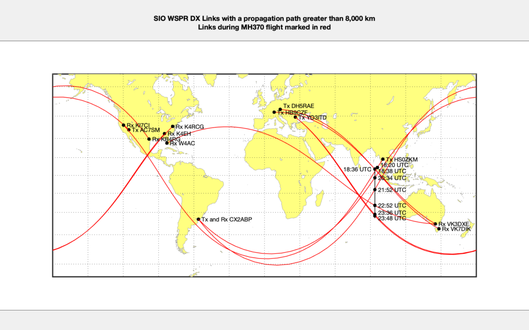
Out of these 91,895 there were 7,708 WSPR DX links over a distance greater than 8,000 km. A DX link is a communication over large or relatively uncommon distances. In the case of MH370 we are looking for WSPR DX links that cross the Southern Indian Ocean (SIO).
Out of these 7,708 WSPR DX links there were only 17 WSPR DX links that crossed the SIO on the short path or direct path between the transmitter and receiver. Out of these 17 WSPR DX SIO links there was only one anomaly on the short path, which is shown in Figure 15 and Figure 16 in the paper.
However on the long path around the globe using WSPR DX SIO links there were eight anomalies and they are listed in Table 2 on page 16 of the paper and shown in Figure 17 and Figure 18.
There are more WSPR links in the earlier part of the flight before reaching the SIO and I am currently analysing the WSPR links during the final major turn (FMT). This is more complicated because of the much larger number of other aircraft operating in the area around Malaysia, Singapore, Thailand and Indonesia.
I also note that I had two figures called Figure 18, my apologies for the confusion and I have now corrected this mistake.
Hi Richard, thank you very much for your clear and complete answer.
Just a last question: how the RX station “knows” that the signal traveled the short or the long path?
PL
@PaxLambda
The Rx station does not “know” whether the WSPR signal travelled the short path or long path or both paths, unless it has a highly directional antenna. In any case this is not recorded in the WSPRnet database, although many operators publish which antenna they use on the internet. WSPR spots are detected by radio stations all over the world on every possible azimuth from 0° to 359°. The azimuth between the Tx and Rx station is recorded in the WSPRnet database, but the reverse azimuth could equally be true.
Some antenna are omni-directional, others are directional from a low to a high degree.
If a Tx station uses an omni-directional or isotropic antenna or an antenna with directional lobes both say North-South or East-West, then the signal will travel both the short path and the long path. The majority of Tx stations want to be received by as many Rx stations as possible.
The majority of Rx stations like to be able to receive from every direction. A typical Rx antenna for frequencies between 30 MHz to 80 MHz is a dipole at 10 meters above ground level. A typical Rx antennas for frequencies between 10 MHz to 20 MHz is a 3-element Yagi at 10 meters above ground level.
Thanks again for your answer… but it brings another question!
If the database doesn’t contain any info about the path(es), how have you concluded that the 8 “long pathes” of the figure 17 were, effectively, long pathes? From the TX antenna? Or because there is no cause along the short one?
PL
@PaxLambda
Simply because each path should be considered both as a short path and a long path.
There are always two ways to reach the same point on the other side of the globe, the short route and the long route.
Yes, I understand that. My question was very badly formulated: Sorry to bother you this way, I try to reforformulate!
The caption of your figure 17 is “Anomalous Long Path WSPR DX links during the MH370 Flight”
What I wanted to ask was: How, in this figure, have you concluded that the “anomaly” was somewhere along the long path? Because there is no cause along the short one? Or from the TX antenna caracteristics?
@PaxLambda
For every WSPR link between a Tx station and a Rx station there are usually multiple examples across a 2 hour period in time. I calculate the mean and the standard deviation of the signal to noise ratio (SNR) of the received signal over a 2 hour time period and look for changes in the SNR by more than the standard deviation. In the FMT tables that I am currently working on, I include both these values. I also compare the SNR with other days at the same time. Hence the reason that I built a database of WSPR links from 28th February 2014 to 21st April 2014.
The Rx station also measures the drift of the received signal compared to the actual frequency of the Tx station, which is digitally encoded and sent in the WSPR protocol to the Rx station. The drift is normally 0 Hz/min but can be up to ± 4 Hz/min.
An anomaly is defined by either a sudden change in the SNR or a non-zero drift or both.
A single anomaly is not significant, but multiple anomalies can be a clue to an aircraft detection. Multiple anomalies can be both from the same WSPR link pair over time when tracking an aircraft from a known start point with a known speed and direction or from multiple WSPR link pairs at the same time that intersect at a specific point.
@All
Below is an overview of the method that I am using to detect the MH370 flight path during the final major turn (FMT) south using a combination of Malaysian civilian radar data, Inmarsat satellite data, ADS-B data and WSPRnet data.
I have chosen the starting point near Penang, Malaysia, as we have detailed civilian radar covering the MH370 flight path in that area. The last civilian radar detection was at 18:00:51 UTC and shows MH370 at around 5.582566°N 99.183389°E, which is 67 nm West-North-West of Penang Airport heading toward waypoint VAMPI in the Malacca Strait. The location south of Penang Island was independently confirmed by the detection of the Co-Pilot’s mobile phone just south of the island at the same time as MH370 was passing according to the civilian radar.
The Australian Defence Science and Technology Group (DSTG) used a similar starting point in their analysis of the MH370 flight path dated 30th November 2015. The DSTG had access to radar data for MH370 at 10 second intervals from just after take off to 18:01:49 UTC. There was one further military radar detection at 18:22:12 UTC, but this was viewed as unreliable. In their book DSTG states “Instead, a prior was defined at 18:01 at the penultimate radar point using the output of the Kalman filter described above. The position standard deviations were at ±1°. The 18:22 radar point, at the end of the radar track, is clearly within the azimuth fan. As described above, the filtered speed at the output of the Kalman filter is not consistent with the 18:25 measurement and predictions based purely set to 0.5 nm and the heading standard deviation to 1°.”
The Malaysian authorities sent a “high-level team” to Beijing to a meeting with the MH370 Next-Of-Kin at the Metropark Lido Hotel two weeks after MH370 was announced missing. The team was led by TUDM/RMAF Chief of Air Operations, Lt. Gen. Ackbal bin Haji Abdul Samad. The MADGE air defence surveillance network was under his command. The team gave an initial presentation to the MH370 Next-Of-Kin in Beijing on 21st March 2014 which included the following slide:
https://www.dropbox.com/s/u4hawzhxpvqi6df/Reuters%20Beijing%20Lido%20Slide.jpg?dl=0
Malaysia has never released the military radar data and the slide was never included in any of the official reports on MH370, although certain radar data was given to the DSTG. Although the first part of the slide aligns with the start of the civilian radar data, there is a large gap in the data near waypoint VAMPI and the second part of the slide does not align with the Inmarsat satellite data. The so called “single radar data point” at 18:22:12 UTC is just off the edge of the slide and does not align with the Inmarsat satellite data between 18:25:27 UTC and 18:28:15 UTC. There has been continuing doubt as to whether the radar trace was from just one source as purported or from multiple sources.
There is also some doubt about how long the Satellite Data Unit on MH370 took to stabilise after being repowered back up, so I have taken the 1st Arc at 18:28:15 UTC at the end of the power up and logon sequence and assumed that by this time the system is stable and providing accurate data.
I used the ADS-B data to identify the movements of the other 55 aircraft in the vicinity of MH370 during the 4 hour period following the diversion (see earlier comment on 13th April 2021 at 22:55). Of course military aircraft and some private flights will not be recorded in the ADS-B data.
I used all the WSPRnet data between 18:00 UTC until after the 3rd Arc at 20:42 UTC and aligned it with the Civilian Radar data start point, the Inmarsat satellite data and the ADS-B data for other aircraft. Both actual and estimated positions of other aircraft were derived from the ADS-B data.
The WSPRnet database provides between 400 and 500 hundred WSPR DX links every 2 minutes during this timeframe. I noted the stable links without any disturbance and the unstable links with a disturbance due to some reason (ionospheric conditions, weather, meteors, ocean movement, aircraft, etc.) Each WSPR link between a transmitting station (Tx) and a receiving station (Rx) was checked to see if it regularly occurred during this timeframe of 2.7 hours and whether it occurred regularly over the 24 hour period on 7th March 2014 as well as previous and following days. The 2 hour mean Signal-To-Noise (SNR) ratio for each link was calculated only when there was a significant frequency of links, otherwise a 24 hour mean SNR was used, but this was only in a few cases. The standard deviation is typically 2.6 dB and values clearly outside the standard deviation in each case were considered an anomaly. The drift is typically 0 Hz/minute but can be up to ± 4 Hz/minute. A few links are prone to drift, so an anomaly was defined as a sudden and obvious change in the drift. A link where the drift is nearly always 0 Hz/minute is deemed anomalous when a drift of at least ±1 Hz/minute occurs. A link prone to a drift of ± 1 Hz/minute was deemed anomalous at 3 Hz/minute or more.
The WSPRnet links form a mesh of electronic tripwires across the FMT area. The following figure gives only a sample of WSPR DX links that cross the FMT area either North-West to/from South-East (Europe to/from Australasia) or South-West to/from North-East (South Africa to/from Asia). With this number of WSPR links pinging every 2 minutes it is hard for any aircraft to escape detection.
https://www.dropbox.com/s/57pk4hcsowe9jxw/FMT%20WSPR%20DX%20Links%20Wide%20View.png?dl=0
For those of you who are analysing the WSPRnet data, you will be familiar with the Maidenhead Grid as shown in the following link:
https://www.dropbox.com/s/y3phkxp5qvgirqt/Maidenhead%20Grid.png?dl=0
The key WSPR links for examining the MH370 FMT flight path are given in the following code sheet, which uses the first two letters of the Maidenhead Grid to define links:
https://www.dropbox.com/s/zaag357kava9d97/FMT%20WSPR%20DX%20Links%20Maidenhead%20Code%20Table.png?dl=0
A close up view of the sample of WSPR DX links is shown against the position of the 1st and 2nd Arc as well as the key waypoints and flight routes in the figure below. It is possible to track an aircraft as it proceeds through the mesh of tripwires and at one moment sets off a trigger and 2 minutes later resets the same trigger. The following trigger in the flight path might be set off 2 or 4 minutes later along the flight path, again to reset when the aircraft has passed.
https://www.dropbox.com/s/i9f36xm94v4htq2/FMT%20WSPR%20DX%20Links.png?dl=0
The initial results are speculation at this stage, but reveal that MH370 may not have followed the path as depicted in the second part of the Malaysian Military radar slide in Beijing.
It appears that MH370 instead of joining flight route N571 at waypoint VAMPI, only crossed the flight route and headed toward Banda Aceh Airport. Instead of landing at the airport, MH370 flew onwards parallel to flight route N571 until it reached flight route P627 where it turned toward waypoint BEDAX and followed along side flight route P627.
This flight path would have taken MH370 close to the Indonesian radar at Sabang. MH370 reaches a point near to waypoint BEDAX at just after 18:42 UTC. This waypoint is close to the 2nd Arc, but MH370 is about one hour too early at the 2nd Arc. It appears that a holding pattern was subsequently flown before MH370 headed further south.
https://www.dropbox.com/s/fm3q6vqzwapvt2n/MH370%20Flight%20Route%20and%20FMT%20WSPR%20DX%20Links.png?dl=0
This method is still subject to refinement and will be explained more fully in a new paper. Behind each red dot in the above figure, there is a full analysis of the WSPR DX links, an analysis of the relevant Inmarsat satellite BTO and BFO data, the location of other aircraft from ADS-B data and the performance capability of the MH370 Boeing 777-200ER aircraft.
@Richard:
Very interesting. There are so many WSPR anomalies near Banda Aceh in short time that you have most likely found something. I recall that there were reports of a group of three Chinese military ships in that general direction from Banda Aceh shortly before MH370 happened.
https://malaysiaflyingherald.wordpress.com/2014/02/14/jalan-jalan-cari-pasal-raaf-monitors-plan-drills-in-indian-ocean/
The source of these WSPR anomalies might be an Indonesian military plane going out over Indian ocean without ADS-B to check out what the Chinese were up to. There is no way to know for sure. If the source was MH370, then it would have had to loiter somewhere near BEDAX for almost an hour. If that was the case then there should be more WSPR anomalies near that area between 18:40 – 19:40.
We also know for sure there was the Singapore military airborne AWACS-style radar aircraft monitoring the shipping lanes that night. Any results captured by that aircraft are in the top secret category, along with other military radar.
If MH370 took the 15-nm N571 OFFSET, it could have been almost side-to-side to EK343, but 15 nm displaced laterally.
@Richard. “The initial results are speculation at this stage………”. Remarkable if borne out.
Thanks for the progress report and the heads up as to potential.
@David
The initial results will indeed be remarkable, if borne out.
@ArtoL
Many thanks for the information about the Chinese military ships.
There are indeed a large number of WSPR links in the MH370 FMT area.
@All
There were 5,600 WSPR Links that crossed the MH370 FMT area on 7th March 2014 between 18:00 UTC and 20:42 UTC every 2 minutes. I have attached an Excel table with all the WSPR links filtered by the Maidenhead 2 letter codes for the Tx and Rx stations:
https://www.dropbox.com/s/fd3ocvqqif7ohq8/WSPR%20Cells%2007032014%20FMT%201800%20to%202042%20Filtered%20by%20Code.xlsx?dl=0
There is a useful online tool called VOACAP for viewing each link. Just enter the Tx Grid and the Rx Grid and you can view the path. There is a very good online user’s manual that shows all the capability of VOACAP, which you will find in the footer of the main page:
https://www.voacap.com/hf/
@Arto L, @TBill,
With the possibility of Malaysian and/or Indonesian military aircraft watching the Chinese naval vessels on exercise in the Indian Ocean based out of Lombok Indonesia, the certainty that the Singapore military aircraft was in the area near the Andaman Islands and patrolling the Malacca Straits and finally the certainty that Emirates UAE343 was on flight route N571 about 4 minutes behind MH370, it is interesting to note that nobody reported sighting MH370.
@Richard,
Really interesting results so far, even if there is a degree of speculation. It has always seemed to me that the offset manoeuvre suggested in more recent potential flight path hypotheses was a little contrived.
Way back in 2014 I was speculating that there could easily have been a holding pattern flown between about 18:xx and 19:00, somewhere in the north Malacca Strait, and before a straight track south began. I needed this holding pattern in order to use up some time. A holding pattern, an orbit, is so easy to accomplish, just by advancing the Heading/Track selector to a new heading, [ahead of the current heading], periodically as the turn progresses. The aircraft will continue to turn to the preselected heading, and then roll out on that heading. The PF can continue to do that within a couple of seconds, with no other input. I continued to speculate on why that may have occurred too.
Brian,
The FMC has a HOLD page that allows the pilot to command a hold at the press of a few keys; inbound course, direction of turn, target speed, target altitude, leg time or distance are all programmable.
Andrew would be the go-to on all the ins and outs of the function but I’m pretty sure that it takes only three key presses to command a standard hold at the aircraft’s present position.
@Brian, @Richard:
I’ve been thinking about a loiter at the north Malacca Strait too. My hypothetical scenario is that MH370 turned first north near IGOGU and descended. Then turned around and flew south via NOPEK. The purpose of this maneuver would have been to mislead Indonesian radar. The descent would’ve been outside their radar range and the radar operators would’ve likely assumed the target flying near NOPEK within Chennai FIR at lower altitude to be different plane than the one that flew northwest along Malacca strait. After passing NOPEK MH370 would’ve turned southwest to get some distance to Sumatra before selecting the final heading to SIO and climbing back to cruising altitude. That way MH370 would have already been out of Sabang radar range when it entered Jakarta FIR.
The arc2 BFO is a bit problematic in this scenario (predicted BFO is too high), but I get a nice fit to BTO/BFO from arcs 3-6 with the final heading being towards NZPG (as with the simulator route) at FL 350. Fuel calculations match MEFE near arc 7 as well. The 7th arc crossing would be at 27.55S 100.17E.
IGOGU to DOTEN (AMVUR) is a shortcut they allow at night (vs. the normal LAGOG to DOTEN), so I have considered that North jog at IGOGU as well.
@TBill:
My theory is that he began descent at closest approach to IGOGU, maintained course parallel to airway N571 until he was below minimum altitude of airway L645 (27000 ft), and then turned north to complete the descent. That way the BFO during the first unanswered satcom call would fit and he would avoid overflying the Nicobar Islands as well. Thus, I don’t believe MH370 went near DOTEN (AMVUR), but instead stayed at the east side of Nicobar Islands. Though we don’t know the exact position of the Singapore AWACS craft that was reported to be in the area, I recall some information was passed to ATSB about it. They introduced a ‘NW point’ in their analysis at 8° 35.719’N, 92° 35.145’E, stating that MH370 didn’t go further NW than that or it would’ve been detected by the AWACS. Victor Iannello made some additional analysis about that back in 2017:
https://mh370.radiantphysics.com/2017/02/11/singapore-radar-and-mh370/
Agree that MH370 did not go to DOTEN (AMVUR) but might have faked a heading change in that direction at IGOGU.
@Brian, @Mick Gilbert, @Arto L,
I have rechecked my initial results which are so far only based on 11 possible detections of MH370 between 18:00 UTC and 19:00 UTC.
There is a total of 5,665 WSPR links that cross the MH370 FMT area between 18:00 UTC and 20:42 UTC. 199 WSPR links are short path forward scatter links and a further 48 are short path back scatter links. The majority of 5,418 WSPR links are long path links.
5,158 WSPR links occur multiple times during this 2 hour 42 minute timeframes. There are a total of 567 different pairs of TX and Rx stations involved.
I have been able to detect the Emirates flight UAE343, the Indigo flight IGO053 and other flights in the ADS-B database as they progressed through the FMT area.
It appears that MH370 passed fairly close to Banda Aceh Airport parallel to flight route N571 and then joined flight route P627 near waypoint POVUS. MH370 continued on flight route P627 until shortly before waypoint GUTOX to then return to meet the 2nd Arc via 02S92E, which is the point where the Jakarta, Melbourne and Colombo FIR meet. The initial results are still speculation pending the evaluation of all the WSPR links during the FMT and the rest of the flight, but it would appear that the FMT took place at a normal cruising speed and without any holding pattern.
And if you project GUTOX – 02S92E I’m pretty sure that it will take you to the Cocos Islands. That’s at the very least interesting.
In my orig 180 South CTH path, I show MH370 coming southeast down L896 (from the direction of P627) and FMT is in progress at 1941 Arc2 L896 directly north of ISBIX.
Basically I projected backwards from ISBIX and found the FMT turn was off of L896.
This type of flight path is borderline may violate Brian Anderson’s rule-of-thumb that MH370 could not have hit Arc2 flying in-bound from the west of Arc2, but if a flight simulator can fly it, then it is probably OK path. But I believe as a policy matter, IG choses paths consistent with Brian’s rule, but there could be exceptions.
@TBill:
I’d say that path fits Inmarsat’s data at arc2 especially if the FMT was just completed before the handshake and the plane was already heading south. I can’t figure out any plausible reason for the detour that far west though. The path Richard derived from the WSPR data, which I still think may have been a different (military) plane flying with no ADS-B, would keep him out of Jakarta FIR except near the northwest tip of Sumatra, but this path would require him to first detour west out of Jakarta FIR only to fly back in north of ISBIX.
@David
Prof. Chari has not done an updated drift analysis and there is no reason to. Debris recovered after 2018 is too late and will not change the analysis. Chari’s original drift analysis predicted accurately where and when debris would wash ashore, and led to finding half of the recovered debris from mh 370. The area he recommended searching for the crash site has still not been thoroughly searched: between 32°S and 34°S. The Ocean Infinity search was narrowed at those latitudes, and Chari recommends widening it to 70 nm on both sides of the 7th arc. The centerline at the foot of Broken Ridge that was not searched by Ocean Infinity should be done with their superior technological capacity, because the first search by others could have missed the debris in the rough underwater terrain.
@BG370. Thank you for that. If not oceanography, such as longitude probabilities, do you know what his 70 miles recommendation is based on?
@David
His recommendation is based on oceanography alone.
@All
I have observed an interesting phenomenon in analysing WSPR links. I have often detected 2 or 3 parallel WSPR links close together from adjacent Tx stations to the same or adjacent Rx stations, which are detecting the one and the same aircraft. This raises the question as to what size cross section an aircraft presents to the propagation path of radio waves, that are reflected or scattered by the aircraft at any particular point in time and space.
From the YouTube video I previously posted and included in the above paper, Air Corsica flight CCM772 was flying at around 410 knots at FL360. The transmission could be heard only when the aircraft passed over the propagation path for a period of about 24 seconds with a lot of noise in the background. The transmission could be heard fairly clearly with little noise for 6 seconds, which represents at 410 knots a distance travelled through the air by the aircraft of 1266 m. This distance is much larger than the length of the A320 aircraft (37.6 m) or the wingspan (34.1 m).
A WSPR transmission can by definition detect a weak signal with a poor signal-to-noise ratio.
WSPR transmissions are not just reflected or scattered by an aircraft, but also by the wake vortex of the aircraft. This creates a much larger “footprint” of the order of magnitude of 1 square km depending on the size and speed of the aircraft and the density of the surrounding air.
This explains why I am having good success using WSPR anomalous and stable links in detecting the track of MH370 and other aircraft on 7th March 2014 from 18:00 UTC to the end of flight.
Wake of an Aircraft
In the paper entitled “Scattering Mechanism of Aircraft Wake Vortices generated in Clear Air” by Jianbing Li, Xuesong Wang and Tao Wang they conclude that the wake of an aircraft scatters radio waves in two different ways.
The wake vortex scatters radio waves due to the density variation of the air and also due to water vapour variation of the air, depending on the frequency of the radio wave. For WSPRnet frequencies, predominantly 3 to 30 MHz, the density variation of the air in the wake will be dominant.
“In order to provide help to the development of radar detection technology on wake vortices, the scattering mechanism of wake vortices is studied. The dielectric constant of wake vortices is divided into two terms regarding the density variation and water vapour variation, respectively. The effects of these two variations on the Radar Cross Section (RCS) of wake vortices are investigated to find the scattering mechanism. Research findings show that in the low frequency band, the density variation is the dominant factor to the total RCS of wake vortex; while in the high frequency band, the dominant factor turns to be the water vapour variation.”
In his paper entitled “Aircraft Wake Vortex Evolution and Prediction” by Dr.-Ing. Frank Holzäpfel of the Technical University Munich explains that the strength of a wake vortex is based on the weight of the aircraft, the density of the air, the wing span and the speed of the aircraft.
“The strength of wake vortices is usually expressed by their circulation, Γ. When the forces which act on the aircraft are in balance, the initial circulation corresponds approximately to
Γo = Mg / (π/4 ρBV)
Thus, the strength of the vortices is proportional to the weight of the aircraft, Mg, and inversely proportional to the air density, ρ, the wing span, B, and the flight velocity, V. Interestingly, the circulation achieves similar magnitudes for both a cruising aircraft at high altitude and an aircraft during approach to an airport at low altitude because the inverse variation of flight velocity and air density roughly compensate each other, respectively.”
Aircraft Wake Vortex with no Engine Power
The strength of an aircraft wake vortex is due to its weight, wing span and speed. As long as an aircraft has speed, even without engine power, there will be a wake vortex simply because the aircraft has a certain weight and wing span.
WSPR Links down to Low Altitude
The flight of two Airbus H125 helicopters near Davis Station in the Antartica on 27th February 2021 between 07:45 UTC and 09:07 UTC was detected by a WSPR link between Tx DP0GVN and Rx ZL2005SWL at 08:24 UTC. The Airbus H125 helicopter is small compared to a B777 and according to FlightRadar24 was only at an altitude of 2,150 feet.
@RobW detected the two Airbus H125 helicopters at the Australian Davis Station way East of DP0GVN. There were receptions from Tx DP0GVN in Antarctica in New Zealand by Rx ZL2005SWL, a distance of more than 7,500 km. There had not been any receptions for the previous 10 days, due to lower solar flux index (SFI) and geomagnetic storms. Quite probably also because there were no targets, but propagation conditions improved. So the propagation conditions make a big difference, but MH370 flew in very good propagation conditions. If helicopters can be detected, then altitude would appear not to be an issue to detect a low flying search aircraft or MH370.
Detecting MH370 at the End of Flight
On 8th March 2014 between 00:00 UTC and 00:30 UTC there were an average of 304 WSPR links every 2 minutes. This is an adequate sample size to produce between 1 and 3 anomalous WSPR links in the area of interest every 2 minutes even down to low altitudes.
Obviously one WSPR detection can only show the progress on a known path based on the assumed aircraft speed and direction. Two simultaneous WSPR detections can intersect at a particular point with an area of uncertainty. Three simultaneous WSPR detections that intersect at a particular point can reduce the area of uncertainty significantly.
The Maidenhead Grid is typically expressed using 6 characters in the format XXddxx, where XX are A to R (18 subdivisions of 10° of Latitude and 18 subdivisions of 20° of Longitude), dd are 0 to 9 (10 subdivisions of 1° of Latitude and 10 subdivisions of 2° of Longitude) and xx are a to x (24 subdivisions of 2.5’ of Latitude and 24 subdivisions of 5.0’ of Longitude). The earth’s surface is covered by 18 x 18 = 324 Maidenhead Grid cells using 2 characters, which are further subdivided by 10 x 10 = 100 cells using 4 characters, which are further subdivided by 24 x 24 = 576 cells using 6 characters. This gives a total of 18.7 M cells. Using this system, a station’s location is identified to within 5.6 nautical miles, anywhere on the surface of the Earth.
Using WSPR detections of MH370 together with the Inmarsat satellite BTO data at the end of flight, will enable the crash location to be determined to within an area of 7,600 sq km (2,200 sq nm).
@Arto L
You stated. “The path Richard derived from the WSPR data, which I still think may have been a different (military) plane flying with no ADS-B, would keep him out of Jakarta FIR except near the northwest tip of Sumatra, but this path would require him to first detour west out of Jakarta FIR only to fly back in north of ISBIX.”
The hypothetical and speculative path that I have proposed leaves the Jakarta FIR on P627 at waypoint NIXUL and does not return to the Jakarta FIR.
MH370 continues to almost waypoint GUTOX and then turns South East to meet the 2nd Arc via 02S92E, which is the point where the Jakarta, Melbourne and Colombo FIR meet. MH370 does not actually enter the Jakarta FIR at this point, but continues on South-East into the Melbourne FIR to meet the 2nd Arc. As Mick Gilbert observed this track would eventually reach Cocos Island (YPCC) which is 673 nm from 02S92E.
@Richard:
Yes. That is true. I was referring to TBill,s hypothesis where MH370 would return to Jakarta FIR via airway L896 north of ISBIX. Your hypothesis makes more sense in that regard. However, the BTO timing at arc3 will be problematic if 2nd arc crossing is that far south.
@All
On 9th April 2014 the Malaysian Office of the Chief Inspector of Air Accidents published the MH370 Preliminary Report.
It took me until 25th August 2014 to discover a wayward “Yellow Pin” on page 1 of a map in an appendix to the Preliminary Report. I am sure other analysts spotted this much sooner. There are a series of yellow pins marking the route taken by MH370, but off to the left there was an unexplained solitary “Yellow Pin”.
https://www.dropbox.com/s/z0697bufi49fl6p/Preliminary%20Report%20Map%201%20Part%20Yellow%20Pin.png?dl=0
The ATSB divulged that there was possibly “a turn at the north western limit at 1912”. Niels Tas asked the ATSB what this “Yellow Pin” represented and the explanation was that this was the 19:12 UTC N.W. Point. The ATSB explained in an email to the IG in a discussion led by Victor Iannello “How it was determined was provided by one of the JIT and as I provided below to Niels Tas. I take it that all radar sources (both mobile and stationary) were considered to define that point and what these sources were on a need to know basis.”
I have used the WSPRnet data to try and possibly locate the Singapore Gulfstream G550 CAEW which was patrolling the area around the Andaman Islands and the Malacca Strait on the evening of 7th March 2014. The airborne radar is an IAI EL/W-2085 which is an active electronically scanned phased array system, with a maximum range of 243 nm (or 450 km). The aircraft came into operation in 2012.
Here is a link to a map of the area which shows how MH370 may have avoided detection by the Singapore airborne radar based on a possible fix of the aircraft using the point of intersection of two anomalous WSPR links at 19:14 UTC. These are early days in the use of WSPR technology for aircraft detection, so it is quite possible that these two WSPR links were detecting something else.
https://www.dropbox.com/s/33bmbb748ihfx3q/Anomalous%20WSPR%20DX%20Links%20at%201914%20UTC.png?dl=0
Richard here is reference to the shipping lanes being monitored by the Singapore aircraft. May impact route flown.
https://www.vox.com/2016/4/25/11503152/shipping-routes-map
I assume ship traffic does not effect WSPR, but one shipping lane goes southwest approx along P627 and the other lane goes straight over to India approx along N6 Lat
Richard: My copy of the April 9 Report is 5 pages long with no appendix. Can you provide the complete document with appendix showing the map?
@ALSM
The following link from CNN allows you to scroll through each section of the document:
https://edition.cnn.com/interactive/2014/04/world/malaysia-flight-documents/
@ALSM
This is the Maps Appendix as a separate .pdf
https://www.dropbox.com/s/4wylutgs26k4waj/Preliminary%20Report%20MH370-maps.pdf?dl=0
I haven’t read the full report but I do have serious concerns on the use of WSPR signal reports on HF to pinpoint an aircraft many thousand kms away.
As a ham operator that uses WSPR extensively on 10m, 6m & 2m, I focus my attention to aircraft scatter on 2m where we can achieve scatter propagation by bouncing signals off the base of large aircraft up to 800km away. This mode of propagation does not work on HF (below 50mhz) due to the longer wavelengths being too big to reflect off the plane’s body and the maximum scatter distance (on VHF/UHF) cannot practically exceed ~800km due to the curvature of the earth and ceiling height of the aircraft. The additional noise on HF would also be a kill factor for detecting the extremely small signal reflections on HF even if they did occur. We know all of this from practical experimentation and my own 10m WSPR system demonstrates that it’s not possible to use this mode even at the top end of HF, demonstrated by the lack of spots to users that can only see my VHF signals up to 800km away along the busy flight paths from Sydney. I have also set up a 2nd remote station 280km away and use this to test 2m and 10m signal paths, where aircraft scatter can be clearly seen to enhance the 2m path, but with no corresponding change on the 10m received signals measured at the same time, as one would expect.
In terms of what is being proposed in this new theory, the only way a HF signal could reach the MH370 aircraft at distances over 4000km is via F layer propagation , meaning any signals being received by the reporter are also via the same F layer propagation. The idea that HF WSPR spots between two stations 10,000km apart are the result of aircraft reflections is completely impossible once you understand the radio physics. Basically this propagation method is limited to VHF/UHF and has a maximum (symmetrical) scatter distance of up to 800km. Sorry to be a spoiler but that’s the reality.
@ John Moore (VK2IJM)
Welcome to the blog!
No need to say sorry, we appreciate an open scientific debate.
I respect the opinion that you hold on WSPR transmissions detecting aircraft, but I believe you are not considering the full picture.
I appreciate that you dismiss the 59 multiple intersecting WSPR positional indicators and 77 single WSPR progress indicators during the flight of MH370 as “completely impossible once you understand the radio physics”.
May I therefore ask your opinion on the paper titled “Scattering Mechanism of Aircraft Wake Vortices generated in Clear Air” by Jianbing Li, Xuesong Wang and Tao Wang.
May I also ask your opinion on the paper titled “Aircraft Wake Vortex Evolution and Prediction” by Dr.-Ing. Frank Holzäpfel of the Technical University Munich.
Please see my previous comment on these two papers dated 21st April 2021 at 11:09:
https://www.mh370search.com/2021/04/03/wsprnet-and-inmarsat-satellite-data/comment-page-1/#comment-595
May I also ask your opinion on the presentation by Dr. Robert Westphal titled “Geocaching in the Ionosphere” given at the international amateur radio scientific workshop HamSCI 2021 held on 19th – 20th March 2021 and hosted by the University of Scranton, Pennsylvania, USA.
Please see the Guest Post on 22nd March 2021:
https://www.mh370search.com/2021/03/22/guest-post-by-dr-robert-westphal/
There are a number of other studies on the subject of aircraft detection, WPSR and the radio physics involved that present an alternative view to yours. Are they all wrong?
Is the raw data from WSPRnet around these times available for download somewhere? Ideally for a day or two, not just the few hours.
I would like to see what bands and SNRs each of your anomalies refer to. It would also be very interesting to run raytracing between the TX and RX points, to see just how many ionospheric hops there are, and what kind of multi-path propagation environment may exist for each TX/RX combination.
There’s an awful lot more than just aircraft that can cause large changes in reported SNR, especially over long radio paths. Without accurate knowledge of the ionospheric conditions at each of those refraction points, trying to make meaningful sense out of the SNR values is… challenging at best.
@Mark Jessop (VK5QI)
The raw data from WSPRnet is available for download from:
https://wsprnet.org/drupal/downloads
The anomalies I detected during the flight of MH370 comprise transmissions using a variety of bands.
As I state in my paper “WSPR technology is novel and is subject to many factors that affect the ability of the ionosphere to propagate, time of day or night, sunspot cycle, meteor scattering, auroral back scattering and sporadic E-propagation. Searching for MH370 using WSPR data has a particular advantage in that there was a solar peak in April 2014, which only happens every eleven years.”
I am sure you are familiar with tools like PropLab Pro V3.1 for ray tracing.
Rather than point to a series of studies, it will help in this discussion to describe the exact manner in which this WSPR propagation is being facilitated by a small object flying in the lower troposphere >5000 km from the TX and RX WSPR stations. Correlation does not prove causation and certainly not when we expect this propagation to occur through known atmospheric physics.
To prove such a theory might be possible, you would need to estimate the amount of RF transmitted by the sending station that is refracted off the ionosphere back down to the aircraft, then reflected by the aircraft back up into the ionosphere and then refracted back down to the far end station over a 13,000m path and then determine the expected receive signal level (assuming an average noise level).
What we do know from extensive testing on VHF (where this is a documented mode of propagation) is that using high gain yagi antennas with low angle take-off and with reasonable power levels of 10W or more, we can expect RX signal levels at the low end of WSPR capabilities >20db below the noise floor at distances ~600-700km, where each station’s antenna has LOS to the aircraft. If you could add the additional losses for a 13,000km path, including the losses due to ionosphere refraction, you would end up with a very small signal indeed. Of course we also know that this mode of propagation doesn’t work on HF, even over short distances due to the well understood relationship between the aircraft surface area versus wavelength. Short of a really big and reflective UFO over the Indian ocean, the WSPR theory falls well short IMO.
@ John Moore (VK2IJM)
By your own admission: “I haven’t read the full report”.
You are obviously not following the blog and raising issues, that have already been discussed.
You refuse to read the key research papers that form the foundation of my approach.
“As a ham operator that uses WSPR extensively” you ignore the research work on WSPR aircraft detection pioneered by a fellow radio amateur and WSPR expert Dr. Robert Westphal (DJ4FF).
You reject a scientific discussion on the issues that you raise.
I fail to see how I can help you.
The purpose of this web site is scientific exchange regarding the search for MH370.
You will have missed the first comment on the web site from Dr. Duncan Steel (a pioneer in the search for MH370) so to save you looking it up here it is:
“The search for MH370 continues, and Richard Godfrey’s new dedicated website will surely be a valuable resource for all those interested in applying science-based analysis techniques to the sparse set of data that we have available, in the quest to determine as precisely as is feasible the location where it hit the sea in the southern Indian Ocean. Like Richard, I am one who does not suffer fools gladly, and since MH370 went missing there have been many fools wanting to broadcast their own particular thoughts about what happened, disregarding what we actually know for sure: the sparse data mentioned above. Doubtless many of those fools will try to comment here, but in the spirit of true science Richard will apply peer-review standards to submissions: rejecting those that do not conform with known information, whilst allowing others that offer something of value regardless of whether they are in accord with his own working hypotheses based on the information we have. This is how science should work: consider all potentially-valid interpretations, and adjust one’s own working hypotheses in line with developing understandings. I look forward to seeing what new ideas turn up here.”
If you only wish to abuse this web site and its readers with your opinions which are at odds with the empirical evidence of 136 WSPR detections during the flight of MH370 and current academic research into WSPR technology, aircraft detection and radio physics, then you are better of taking your accusations that “The idea that HF WSPR spots between two stations 10,000km apart are the result of aircraft reflections is completely impossible once you understand the radio physics” elsewhere. Since you believe that my hypothesis is complete bull shit, I frankly do not understand why you bother to comment here.
I welcomed you and invited you to a scientific discussion, which you clearly are not willing to have and in my view have firmly rejected.
Hi Richard,
Can you point me to a research paper where it is demonstrated that WSPR signals can be correlated against aircraft in known positions on these HF frequencies and where the distance between the stations is over 10,000km and involve multi-hop propagation modes of up to a dozen hops ?. This should be easy to do using the live data from flight radars and existing WSPR stations and it would prove or disprove the methodology.
Don’t get me wrong here, but as a user of the system I cannot detect anything of significance wrt nearby aircraft over short distances on HF frequencies due to the small signals involved and inherent background noise. Of course VHF WSPR over 800km is a different story, but we are talking HF here. I am aware of OTHR systems that use HF radar to detect planes and ships over a single hop, but these run 500kw transmitters and have advanced doppler detection systems to decode the data, rather than a waterfall image from a sound card and numbers in a database.
@ John Moore (VK2IJM)
I have already pointed you to the research and to a previous comment on this blog explaining the research. I cannot read the comment and the research for you. Please do your own homework. I am not your unpaid consultant or secretary.
You state that I am wrong to assume “WSPR propagation is being facilitated by a small object flying in the lower troposphere”. The flaw in your thinking is you consider only the “small object” by which I presume you mean the physical metal structure of the aircraft. You are ignoring the possibility that the ‘footprint’ is much larger and includes the vortex wave.
I explained in the previous comment on this blog to which I referred you, that “I have observed an interesting phenomenon in analysing WSPR links. I have often detected 2 or 3 parallel WSPR links close together from adjacent Tx stations to the same or adjacent Rx stations, which are detecting the one and the same aircraft.” How did that happen?
I referred to flight CCM772 and a YouTube video showing the aircraft detection over a distance of 1266 m, which is much greater than than the 37.6 m length of fuselage or 34.1 m wingspan. How does that work?
In Figure 11 in my latest paper you can see that when MH370 made a turn it was detected by several anomalous WSPR DX links. In straight and level flight the number of detections is small. Why is that so?
The “footprint” of an aircraft is much greater than the mere size of a “small object” it is of the order of magnitude of 1 km2. This is also not a “really big and reflective UFO over the Indian ocean” that you mockingly and facetiously refer to in your comment. Instead of laughing at this hypothesis, you should be taking it seriously!
Please go and read the research, that I pointed you to and you will better understand how the aircraft vortex wave is created, how the dimensions of the aircraft vortex wave can be calculated and the significance an aircraft vortex wave has for WSPR transmissions. These are academic research papers, peer reviewed and published in scientific journals. This is not a stupid test in someone’s back yard!
Whilst you are doing your homework and catching up, I will get on with my research, if you don’t mind.
VK2IJM, VK5QI de DJ4FF Hi John and Mark and all the others (Don, …) from the old world
I am active on WSPR top ranking at KB9AMG’s 2-way-WSPR list at the moment, doing WSPR for a little more than a year. Than I stumbled over an article in Daily Mirror on MH370 in mid July 2020.
Amateur radio should always work on the forefront and frontiers of technology for the past 110 years and now. Then comes ham spirit. Emergency assistance and later contesting, DXing, ragchewing etc. are nice but not the main purpose of ham radio.
RADAR suffers from the naysayers from the very beginning in 1904. Christian Huelsmeyer holds the first patent Number 165.546 on RADAR in history (not Sir Wtason-Watts). The German Imperial Navy did not understand the benefits and rejected his work. So the Germans lost 20 years of lead in RADAR technology. Huelsmeyer migrated to other fields. (www.navweaps.com and Wikipedia).
In 1995 we got the first patent on multistatic passive GNSS radar and presented at the International RADAR conference in Washington D.C. The Germans did not understand the benefits of detecting stealth bombers with ultra low power from the nav satellites (much lower than WSPR) and lost the lead in passive RADAR technology. Today you find numerous papers on passive GNSS RADARs even with SAR and ISAR capabilities. Mainly China and also Australia. I migrated to other areas of commercial electronics.
Mid July 2020 I started working on WSPR passive HF detection as MH370 was still missing and current technology did not do much help to find it. In November 2020 I detected and tracked flight QFA114 from JNB to PER with nice WSPR signals along latitudes from ZS to VK6 and longitudes from TI4 and many others. I posted my experience on the blog http://www.mh370.radiantphysics.com and got beaten up as usual. Also on vklogger.com but no response there. So I am used to that for many years. People praise invention and innovation as long as it is not within their own zone of comfort and does not hurt their business. But disruptive technologies will do that.
Richard Godfrey was the only one who listened and gave it a try. I totally support him with regard to WSPR detection and mostly tracking. With regard to tracking he is more optimistic than I am, but you have to be optimistic on unknown ground. I have tons of WSPR data for the LEP of MH370, mainly long path (LP), and still have my doubts on LP in the case of MH370.
On the other hand MH370 got lost close to the peak of solar cycle 24. So today it is a challenge to repeat the WSPR situation west of Perth. RG and I agree on many specific WSPR anomalies not in all of them, he has a different approach that is good and more than acceptable. That is the way common expertise is evolving. I do not have his expertise with regard to all the aspects in aeronautics and events with regard to flight MH370.
So I recommend to please proceed as follows:
1. Read the epaper at http://www.hamsci.org 2021 titled “Geocaching in the Ionosphere”
2.Go to http://www.kiwisdr.com, select one or more SDRs in Oceania and switch them to WSPR mode. Watch the live signals in the time and frequency domain. In parallel monitor
the ADS-B data in FR24 especially at PER, MEL, SYD and other major airports and draw your own conclusions with regard to raw signal shape, interference and frequency drifts.
Start the easy way, i.e. monitor VK3 signals close to airport MEL with aircraft departing to the West or Northwest and change headings to East. Do that from a SDR East of MEL for example in ZL. Due to the frequency changes you will see many WSPR signals that will not show up in the WSPR data base (www.wsprnet.org) as the drift is higher than +/- 4 Hz/min. Depending on the situation between 30% and 80 % of the raw WSPR signals will not be documented. So a real good WSPR passive monitoring system should process the
raw WSPR signals. Anyway historical data from 2014 will have to be extracted from the WSPR data base (www.wsprnet.org). Someone who has not monitored and studied the raw WSPR signals for quite some time will never become an expert in WSPR with regard to MH370. The epaper describes the 3 phases observation, validation and verification.
I also have quite an extensive draft paper and a data base on MH370, AF447, MH17, QFA114 and others, which are my working tools and not ready for publication yet.
3. I tracked many military aircraft in the Southern hemisphere such as IL-76TD, C17, C130, and special airline flights going to Antarctica from Hobart (HBA), the A319 from the Australian Antarctic Division (AAD), Qantas joy flights towards McMurdo station (QFA290X), C17 to and from Christchurch and others. You do not always have a continous track. I also tracked RAAF flights in Australian territory, and other air forces beween South America and the Northern tip of Anatrctica.
In addition I studied flight QFA2906 heading North from Antarctica towards Perth and ob-served the influence of the B787 outside the baseline VK6 to JH3APN who was also in the air during the night of tragedy. As soon as QFA2906 was app. 1.500 km South of Perth you could see WSPR signal influence in Japan.
4. Read the scientific papers of Australian researchers from DST and others on JORN, SuperDARN etc. with regard to RCS of airplanes at HF, even the ISS, scattering effects, ionospheric backscatter in 2014, travelling ionospheric disturbances (TID),…
5. Do your own testing on various aircraft. I can predict with some certainty that a VK7 signal at HF will be picked up in VK6 as soon as an aircrft will pass a certain point Souhwest of Port Lincoln near Adelaide and vice vera. If you have a poor antenna wait for a big aircraft or ISS passing by and your reception and TX range will greatly increase on HF.
Having done that we can discuss issues. I am 100 % convinced that the detection process works (and consider 30 dB signal processing gain in WSPR) as well as the tracking to some degree. We can discuss accuracies and limitations (it seems not to always work (principle or hidden aircaft without transponders?). Signals passing over the South Pole can be a challenge. Just monitor WSPR recption of DP0GVN at ZL2005SWL or ZL1AML for example.
So please do your home work as active and knowledgeable radio amateurs and we can discuss challenges. I am not willing to spend my spare time banging on each other (ham spirit). Who would have thought what Joe Taylor, K1JT, would accomplish with WSPR and FT8 20 years ago. If you disagree in general that is fine too, then please pursue other venues. I am looking for radio amateurs who will actively support research on this subject on their own efforts. That will be time consuming and will require more work than a couple of hours that you can not spend on the “normal” leisures of our fine hobby.
This approach is less than one year old, so lots of research will have to be done by the ham radio and other communities. That is the original purpose of ham radio since 1914!
Doing radio experiments that no one has done before! That is true amateur radio!
I am very happy to collaborate with Richard who is not a ham and contributes knowledge
and expertise from other fields, such as math, physics, aeronautics, debris analysis, Inmarsat technology and so on. Being good partners does not necessarily mean that we will agree in every aspect on the Search for MH370 but we actively join forces to get things accomplished. Keep on going with amateur radio not just “walking the beaten path”! TNX!
73, 55 from DL to VK de Rob,DJ4FF
P.S: I was not happy with the VHF/UHF Youtube video as I expected reactions as we have now. I am aware of Airscout software and all those things. You better study the scientific paper on detecting the Doppler signal of an aircraft without WSPR by a 500-point FFT at 7 MHz on the signal of Radio Saudi over 4.000 km distance as an example.
@Rob
17 77 88 -.-. …. .- — .–. .- –. -. . 92
What’s at (-2.8926011, 101.3892885) ?
@Eric
Welcome to the blog!
You asked: “What’s at (-2.8926011, 101.3892885) ?”
What time are you considering?