MH370 was a scheduled commercial airline flight from Kuala Lumpur, Malaysia to Beijing, China on 8th March 2014 with 239 passengers and crew. The aircraft for the flight was a Boeing 777-200 Extended Range aircraft, with the registration 9M-MRO. On 8th March 2014 at 00:42 Local Time (7th March 2014 16:42 UTC) MH370 took off, on time, from Kuala Lumpur for the six hour flight to Beijing. Only 39 minutes later, after reaching the initial cruising altitude of 35,000 feet over the South China Sea and approaching the Flight Information Region (FIR) boundary between the Kuala Lumpur and Ho Chi Minh FIRs, the aircraft went dark. All radio communication ceased, no satellite messages were received and the aircraft disappeared from air traffic control screens.
The MH370 last estimated position was 34.2342°S 93.7875°E and the search area is defined as a circle with a radius of 140 nm centred on the last estimated position.
The full paper co-authored by Bobby Ulich, Victor Iannello and Andrew Banks can be downloaded here
Many thanks to Brian Anderson and Sid Bennett for submitting their guest papers.
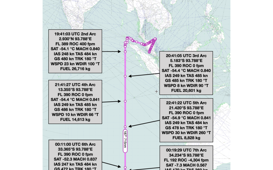
Brian Anderson’s paper “Deducing the Speed of Malaysia Airlines MH370, Mid-Flight” explores the Ground Speed of MH370 from the BTO data and concludes that it was 494 knots between 19:41:03 UTC and 20:41:05 UTC.
Sid Bennett’s paper “The Whereabouts of MH370” explores alternative flight paths into the Southern Indian Ocean and concludes the most likely azimuth was 186.6°T.
Many thanks to Niels Tas for submitting his guest paper, which can be found in the Archive under Flight Path Analysis.
Niels investigates flight paths after 19:41 UTC into the Southern Indian Ocean. He concludes, assuming level flight and LRC speed setting, it is possible to obtain a remarkable straight path at a track of 180 degrees when “navigating” by following the strongly non‐linear BTO curve, just by variation of the initial position. He recommends to consider S34.5 degrees on the “7th arc” as the main centre point for a future search effort.